5.31
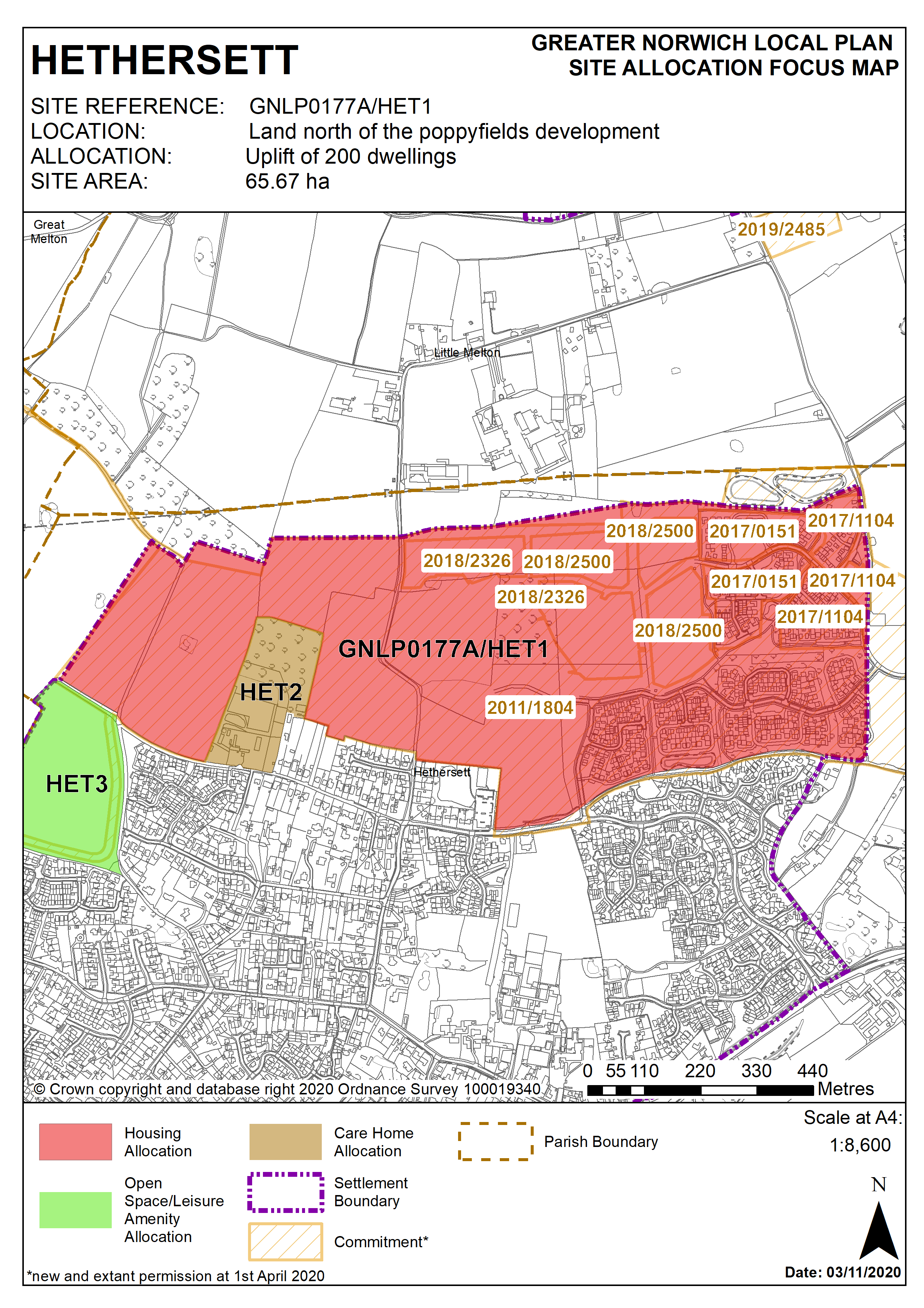
GNLP0177-A to the north and west of Hethersett, which incorporates the existing allocation HET 1, far exceeds the land required for development in Hethersett. Instead, the preferred approach is not to allocate new land for development but to uplift the HET 1 allocation from the 1,196 homes already permitted to an approximate total 1,369 homes, incorporating part of GNLP0177-A. The remainder of GNLP0177-A is not allocated. Development on HET 1 is well-advanced and it has become apparent from the approved reserved matters planning applications that an uplift of approximately 200 dwellings is a realistic prospect. There are no major constraints to accommodating an uplift of 200 homes, subject to ensuring delivery of the policy requirements set out in HET 1, and the mitigation measures already agreed through the approved planning applications. In terms of transport, improvements needed would be an access strategy for all modes of transport, safeguards against increasing traffic through Little Melton, and a cycle link to Colney Lane.
Policy HET 1 (part of GNLP0177A)
Land north Hethersett (approx. 65ha) is allocated for mixed use, to include approximately 1,369 dwellings, community uses, open space and green infrastructure.
The site lies to the north of the Poppyfields development, the plant nursery on Grove Road, Longview, the village hall and Back Lane, and south of Beckhithe Meadow County Wildlife Site (CWS), Holly Tree Farm and south-west of Braymeadow CWS. The allocation has an outline permission for 1196 dwellings (2011/1804) which is under construction. Within the scope of the outline application, intensification has been possible and there is now scope to ‘uplift’ this previous allocation by 200 additional dwellings. There is no specific site within the larger allocation, so this uplift is applied to the entire site. Due to the size of the original allocation, a range of supporting infrastructure and facilities is required, and the following policy applies to the additional 200 dwellings, wherever they may be located within the site. Approximately 65 ha is therefore allocated for mixed use, to include housing, community uses, open space and green infrastructure. This will include approximately 1,369 dwellings.
The developer(s) of the additional 200 homes on the site will be required to ensure the following:
Masterplan and Phasing Plan
- A comprehensive masterplan must include provision of social and green
infrastructure and highway improvements, including Thickthorn junction.
- A phasing plan which clearly identifies when key infrastructure will be provided in relation to the provision of new housing. Phasing should be designed to ensure development minimises the disturbance to existing residents.
- The site should be masterplanned alongside HET2.
Enhanced Facilities
- Community facilities, such as formal open space and/or buildings dedicated to community uses will need to be included within the overall development in accordance with the most up to date needs assessment.
- Expansion of local schools or provision of land for additional school/s will need to be agreed with the Education Authority.
- Development of the site may require financial contributions to fund improvements to the surrounding road network in addition to any Thickthorn junction improvements.
Landscaping and Green Infrastructure
- Layout and landscaping of final scheme must minimise the impact on the strategic gap between Hethersett and neighbouring settlements.
- Design should respond to the layout of earlier settlement patterns around commons and greens or other focal points.
- Design of scheme must integrate landscape, open space and footpaths with the existing settlement.
- Maximise the benefit of green infrastructure provision and avoid adverse impact designated sites, linking ponds, water courses and hedgerows.
- The landscape buffer to the north should provide green infrastructure links between Beckhithe Meadow and Braymeadow County Wildlife Sites and incorporate existing woodland and hedgerow features across the site.
Transport
- A transport assessment must consider the capacity of the improved A47 Thickthorn Interchange
- Highways and transport enhancements to be agreed with the Highways Authority and where appropriate the Highways England.
- Vehicular access onto Colney Lane will be required.
- Footpath and cycle routes to Norwich Research Park and Little Melton will be required, and additional public rights of way to increase access to the countryside.
- Design of scheme must minimise impact on existing roads in the village by limiting the amount of additional traffic accessing the local road network.
Site Conditions and Constraints
- Site layout must account for high voltage power lines to the north of the site, which will need a suitable separation buffer. Other factors affecting the final layout include an oil pipeline crossing north-eastern corner of the site, water mains and sewers crossing the site, and the need for a buffer zone around sewage pumping stations.
- Historic Environment Record to be consulted to determine any need for archaeological surveys prior to development.
- Wastewater infrastructure capacity must be confirmed prior to development taking place.
- Norfolk Minerals and Waste Core Strategy Policy CS16 applies, as this site is underlain by safeguarded mineral resources.
- Mitigation and further investigation with regards to site susceptibility to surface water flooding.
- Avoid contamination of groundwater.
Policy Map