2.55
Barrack Street/Whitefriars is proposed to be allocated in two parts on modified boundaries, as follows:
2.56
The site was the former Jarrolds printworks and the large mid-20th Century building which previously covered the site was identified as a negative building within the City Centre Conservation Area Appraisal. Towards the east of the site was former housing fronting Barrack Street which is now used as a temporary surface car park.
2.57
The western section of the site is within the City Centre Conservation Area and the site also contains standing remains of the city wall (Scheduled Monument), two Grade II listed cottages (77-79 Barrack Street) and two locally listed cottages. The site is situated within the area of main archaeological interest and it has been identified that the site has significant underground archaeological remains. It is important that the development protects and enhances the setting of the wall.
2.58
Development of these sites must be of a scale and form which respects and takes advantage of its riverside context and location in respect to the Broads National Park.
2.59
7-79 Barrack Street are a pair of early 19th Century houses which date from 1916. They are one-up, one-down terraced housing which have been unsympathetically converted and extended at ground floor level. The properties are in a poor state of repair and are on Norwich’s Buildings at risk register. They are rare survivors of one-up-one-down cottages and are reported to be the last in Norwich of this type. These cottages must be brought back into residential use and renovated in order to ensure their future and to remove them from the register.
2.60
There are a number of listed buildings within the vicinity which include St James Mill which is grade I listed, Former Church of St James (Puppet Theatre), C12/13 Undercroft at junction of Whitefriars and St James Court and remains of Anchorite House on Whitefriars. Norwich Cathedral is located approximately 330m to the south of the site.
2.61
On the site there is a mid-20th Century Annex which contains the Jarrolds Printing Museum which was founded in 1982. Whilst the loss of this utilitarian building is accepted, the private collection of artefacts must be recorded and some form of print museum re-provided on or off site. Proposals will be required to adopt and implement a strategy of heritage interpretation relating to the former use of the site as a printworks;
2.62
Development should respect the build line of St James Church and remain subordinate to the church. Development should complement the St. James Mill in terms of height and scale and remain subservient to it.
2.63
There are trees situated along the northern, western and southern boundaries of the site. The site is within 500m of St James Pit SSSI and Mousehold Heath which is a Local Nature Reserve and County Wildlife Site. Train Wood is a non-designated County Wildlife Site that is also situated within 1km. Any loss of trees should be mitigated through replacement planting in order to help soften the development and to contribute towards replacement biomass.
2.64
A noise impact assessment and air quality assessment will be required as the site is situated on Norwich’s inner ring road and is located within the Central Norwich Air Quality Management Area.
2.65
The majority of the site is situated within Flood Zone 2 with a minor area being situated in Flood Zone 3. SUDs will need to be provided as part of the development.
2.66
There is potential for contamination and therefore Ground Investigation Reports will be required.
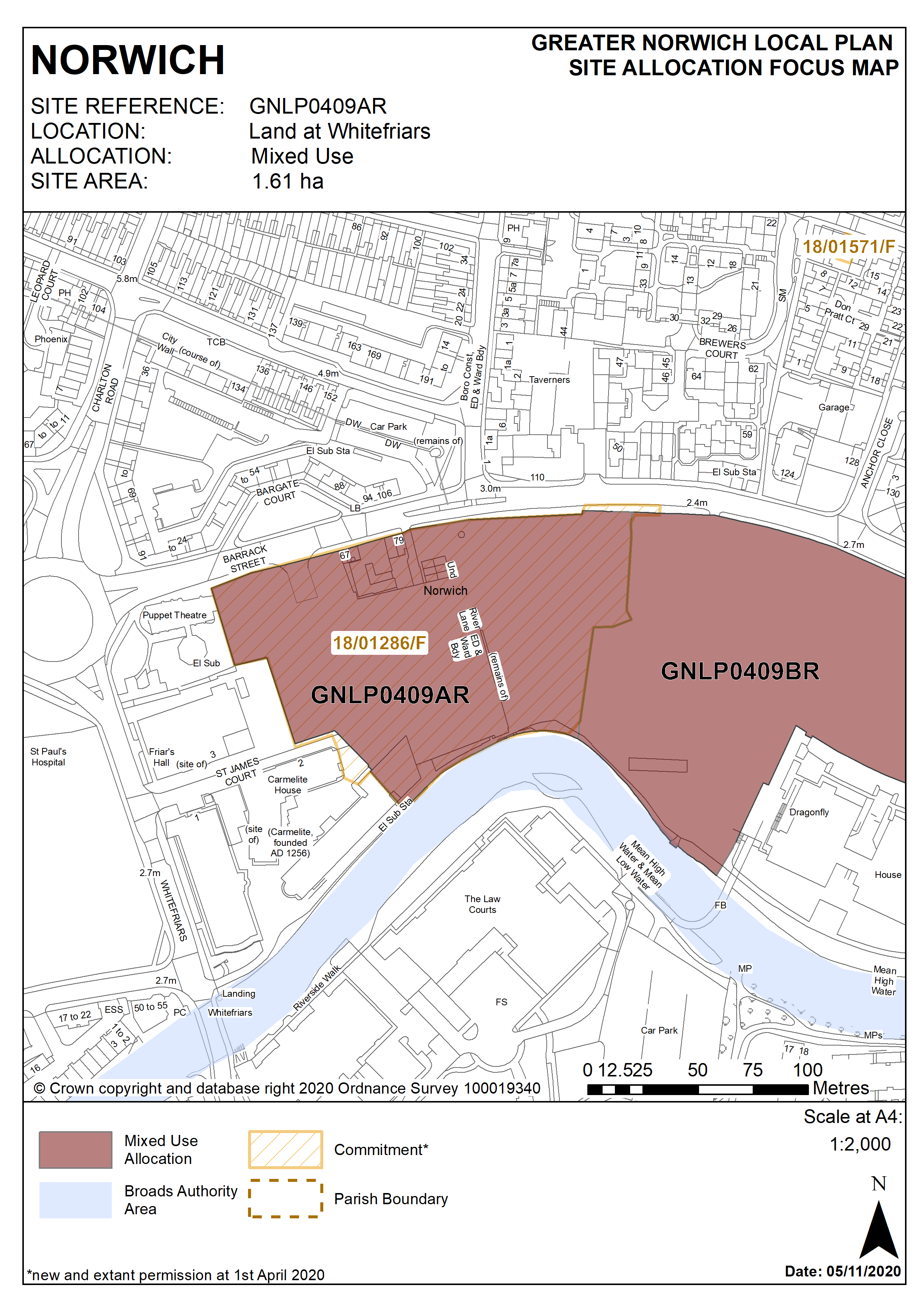
Policy GNLP0409AR
Land at Whitefriars (approx. 1.61 hectares) is allocated for residential-led mixed-use development. This will include a minimum of 220 homes. Offices and managed workspace, ancillary retail use, restaurants, bars, and recreational open space will be accepted as part of a balanced mix of uses.
The development will achieve the following site-specific requirements:
- Achievement of a high quality, locally distinctive design of a scale and form which respects and takes advantage of its riverside context and location within and adjoining the City Centre Conservation Area. Design should distinguish between the areas within and outside of the city walls through layout, scale, height, use of materials and design detailing.
- There will be a general presumption in favour of the repair and re-use of heritage assets on site as part of any site regeneration, however any application for redevelopment will be considered on its merit. Great weight will be given to the conservation of all designated heritage assets. Proposals will enhance the setting of the City Wall scheduled monument and, the two listed cottages at 77-79 Barrack Street must be retained, brought back into residential uses and renovated. Proposals should provide a suitable setting for designated heritage assets affected by the proposals on and off site including key views from and into the site.
- Development proposals should draw upon local character and distinctiveness and preserve or enhance the character and appearance of the conservation area.
- Ensures a high level of flood resilience and incorporates appropriate flood mitigation measures (including addressing identified risks from flooding from rivers and surface water flooding);
- Reintroduce a building line along Barrack Street and a frontage to the river; buildings fronting the river should respond to the height of the mill whilst remaining subservient to it.
- Car free or low-car housing development in accordance with Policy 2 is appropriate in this location.
- Maximises the views across, from and of the river. Retain the existing embankment line and historic features. Enhancement of river access including provision for the extension and maintenance of the riverside walk in accordance with policy 7.1 and the ‘River Wensum Strategy’ (including provision of open space/play provision near the city wall) and the establishment and improvement of pedestrian and cycle routes east-west across the site to connect with the existing cycle network.
- Protect and enhance the significant long views across the site towards Norwich Cathedral;
- A noise impact assessment and air quality assessment will be required, and the development must be designed to mitigate the impact of noise from the main road.
- Proposals will be required to adopt and implement a strategy of heritage interpretation relating to the former use of the site as a printworks;
- High quality landscaping, planting and biodiversity enhancements including protection of trees along the river edge;
- Provision of public realm enhancements including the provision of open space and playspace of an appropriate form and character for the enjoyment of residents and visitors;
- Protection of bankside access for maintenance purposes.
- Vehicular access should be from Barrack Street via Gilders Way.
Policy Map
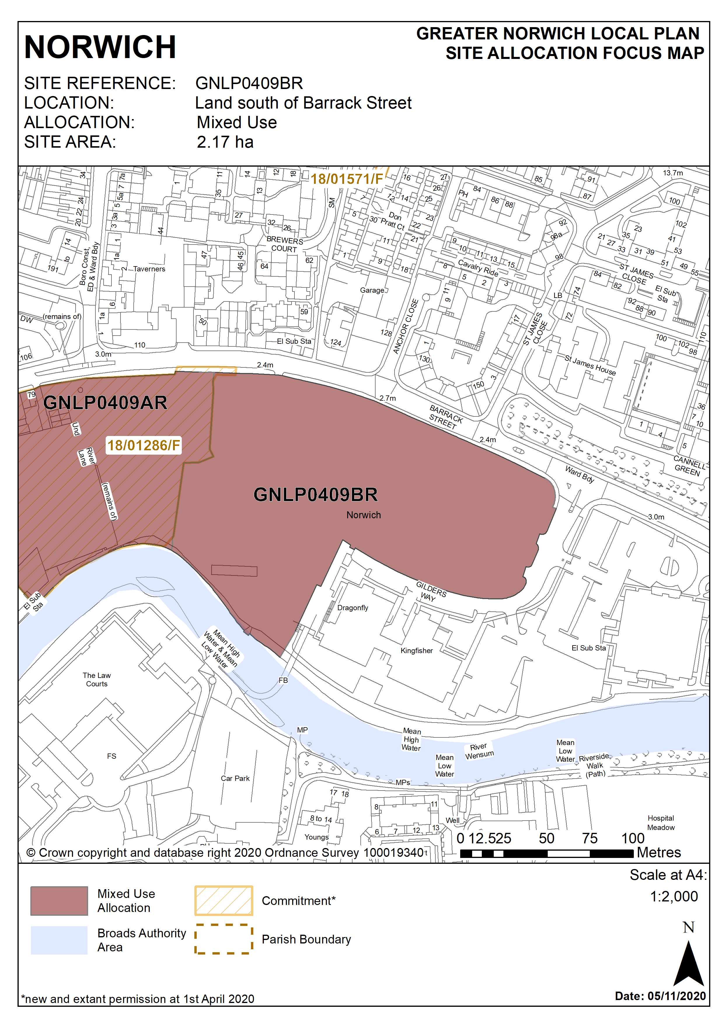
Policy GNLP0409BR
Land south of Barrack Street (approx. 2.17 hectares) is allocated for residential-led mixed-use development. This will include a minimum of 200 homes. Offices and managed workspace, ancillary retail and professional uses, restaurants, cafes and bars, and recreational open space will be accepted as part of a balanced mix of uses.
The development will achieve the following site-specific requirements:
- Achievement of a high quality, locally distinctive design of a scale and form which respects and takes advantage of its riverside context and location adjacent to the City Centre Conservation Area.
- Proposals will provide a suitable setting for designated heritage assets affected by the proposals on and off site including key views from and into the site in particular the significant long views across the site towards Norwich Cathedral.
- Ensures a high level of flood resilience and incorporates appropriate flood mitigation measures (including addressing identified risks from flooding from rivers and surface water flooding);
- The office element of the scheme should be located to extend and consolidate the existing completed phases of the St James’ Place development at Gilders Way;
- Provision of integral and well-designed parking areas to serve existing offices at Gilders Way and St James’ Place as well as proposed office users together with segregated areas of residents parking. Car free or low-car housing development in accordance with Policy 2 is appropriate in this location.
- Incorporates views across, from and of the river. Retain the existing embankment line and historic features. Enhancement of river access including provision for the extension and maintenance of the riverside walk in accordance with policy 7.1 and the ‘River Wensum Strategy’. The establishment and improvement of pedestrian and cycle routes north-south across the site from Jarrold Bridge to Barrack Street and improve east-west links to connect with the existing cycle network.
- A noise impact assessment and air quality assessment will be required, and the development must be designed to mitigate the impact of noise from the main road.
- High quality landscaping, planting and biodiversity enhancements including protection of trees along the river edge;
- Provision of public realm enhancements including the provision of open space and playspace of an appropriate form and character for the enjoyment of residents and visitors;
- Protection of bankside access for maintenance purposes.
- Vehicular access should be from Barrack Street via Gilders Way
Policy Map