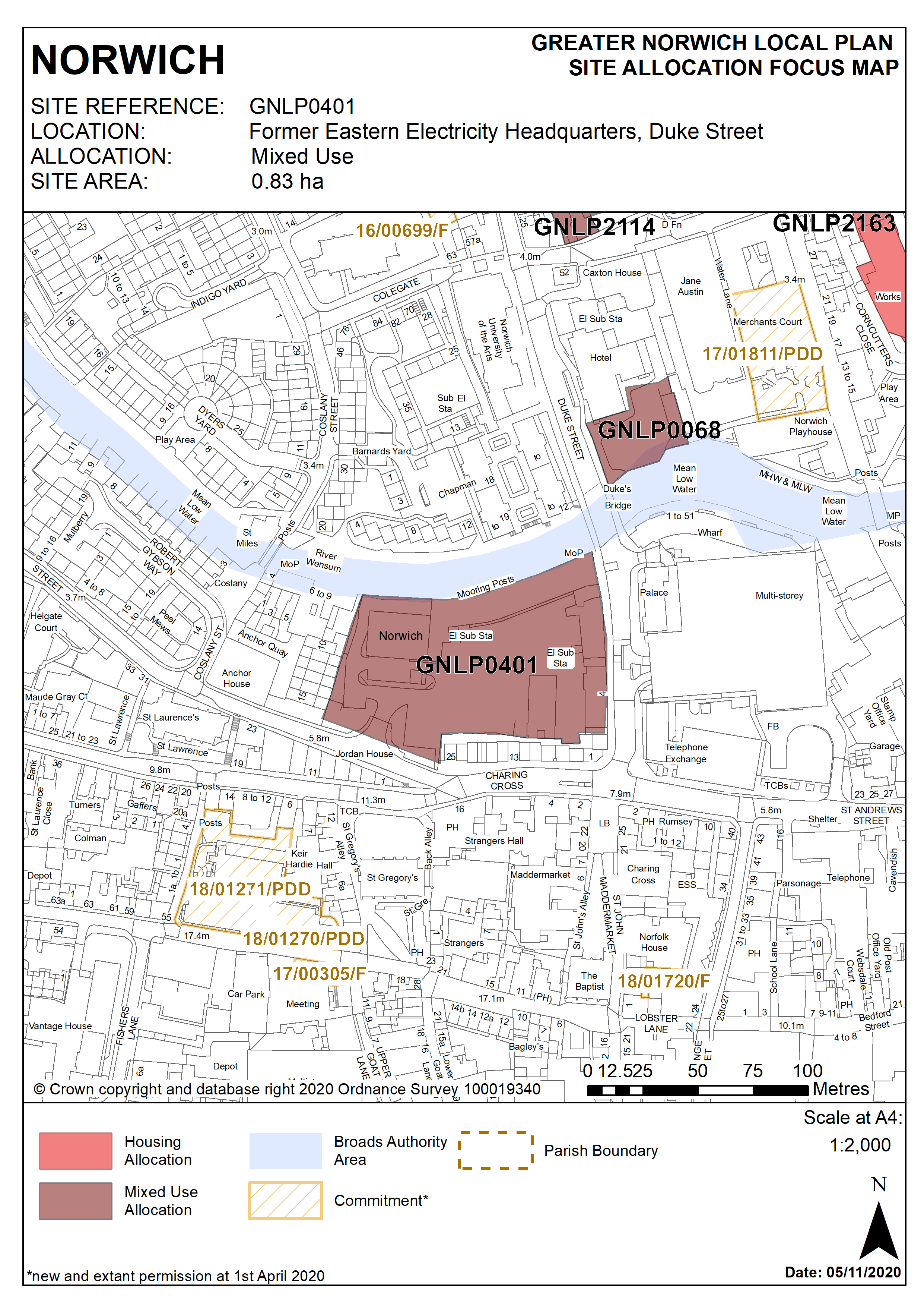
2.47
The former Eastern Electricity Board (EEB) site is located on the south bank of River Wensum and is 0.83 hectares in size. The site contains the vacant electricity buildings along the river and the former Boardman buildings fronting Duke Street. The site has two main vehicular access points, from Duke Street and Westwick Street. The site frontage on Duke Street and adjacent to the river is identified as ’positive’ in the City centre conservation area appraisal.
2.48
The site borders existing residential development on the west side. Duke Street is part of the city's one way system. Adjacent to and south of the site are 1-25 Charing Cross which is dominated by professional services. In the middle of the site is a large open space which is currently in use as a temporary car park.
2.49
The riverside area has been the focus of activity for most of Norwich’s history and contains remnants of its former importance. Today, the focus of this activity has shifted from industrial concerns to leisure pursuits and the area is rapidly becoming a popular residential location with many new developments currently underway or in the pipeline.
2.50
Development of the site must take account of its constraints which include its location adjacent to the River Wensum and inclusion in flood zones 2 and 3, its location in the City Centre Conservation Area and Area of Main Archaeological Interest and adjacent to the Broads National Park, possible contamination, access, site levels and scale of adjoining development and buildings. Development must maintain and/or recreate strong built frontages to Westwick Street, Duke Street and the River Wensum. Development must be of a scale and form which respects and takes advantage of its riverside context.
2.51
The site is likely to accommodate at least 100 homes, or if the site is developed to include student accommodation (at least 250 bedrooms). More housing may be accommodated, subject to an acceptable design and layout being achieved.
2.52
Consent for 69 flats to be delivered through conversion of existing buildings under previous approved proposals have now expired.
2.53
The site lies in present day Flood Zone 2, but once climate change is added to the flood levels, the majority of the site lies in Flood Zone 3a High Probability. If possible the development should be sequentially sited on land to the south in Flood Zone 1.
2.54
If development is required to be sited within these future Flood Zone 3 (1%cc) outlines then the more vulnerable residential development will need to be designed with floor levels raised 0.3m above the flood levels for the future 1% (1 in 100) annual probability flood event with 35% and ideally 65% allowances for climate change. Refuge will also need to be provided above the 0.1% (1 in 1000) annual probability 25% climate change flood levels. Compensatory flood storage will also need to be provided for any new built development or land raising within the 1% (1 in 100) annual probability flood outline with 35% climate change to ensure no increase in flood risk elsewhere. This will require lowering of higher land in Flood Zone 1 to the south to provide the compensatory flood storage.
Policy GNLP0401
Former Eastern Electricity Headquarters, (Duke’s Wharf) Duke Street (approx. 0.83ha) is allocated for mixed-use development which may include a minimum of 100 homes, (or, if the residential element is provided as student accommodation, at least 250 bedrooms). Employment, managed workspace, leisure, financial and professional services, education and cultural uses will also be acceptable as part of a balanced mix.
The development will achieve the following site-specific requirements:
- Achievement of a high quality, locally distinctive design of a scale and form which respects and takes advantage of its riverside context and prominent location within the City Centre Conservation Area and Broads National Park, maintains and/or recreates strong built frontages to Westwick Street, Duke Street and the River Wensum, ;
- Conserve and enhance the significance of heritage assets (including any contribution made to their significance by setting) including the City Centre Conservation Area, Grade I listed St. Gregory’s Church and Strangers Hall Museum, grade II* listed Charing Cross and other buildings listed at grade II.
- Ensures a high level of flood resilience and incorporates appropriate flood mitigation measures (including addressing identified risks from flooding from rivers and surface water flooding);
- Decommissioning and removal of the existing surface car parking;
- Development may include either the conversion of existing buildings or redevelopment;
- Provision of pedestrian links from Westwick Street to Duke Street and Dukes Palace Bridge, improved permeability of the site making the most of its riverside location;
- Inclusion of low-car or car-free housing, in accordance with policy 2, where consistent with scheme viability;
- A noise impact assessment and air quality assessment will be required, and the development must be designed to mitigate the impact of noise from the main road;
- High quality landscaping, planting and biodiversity enhancements;
- Heritage interpretation measures to be incorporated in accordance with Policy 3 of this plan.
Policy Map