2.346
The site was allocated in the previous Local Plan for a mixed-use development of up to 75 homes and employment uses. Current aspirations on this Council-owned site are to deliver a residential-led scheme with a substantially increased number of homes, alongside associated community uses. The principle of development on the site has already been accepted, and it is expected that development will take place within the new local plan time-period up to 2038. As an existing allocation it has been considered in the calculation of the housing requirement.
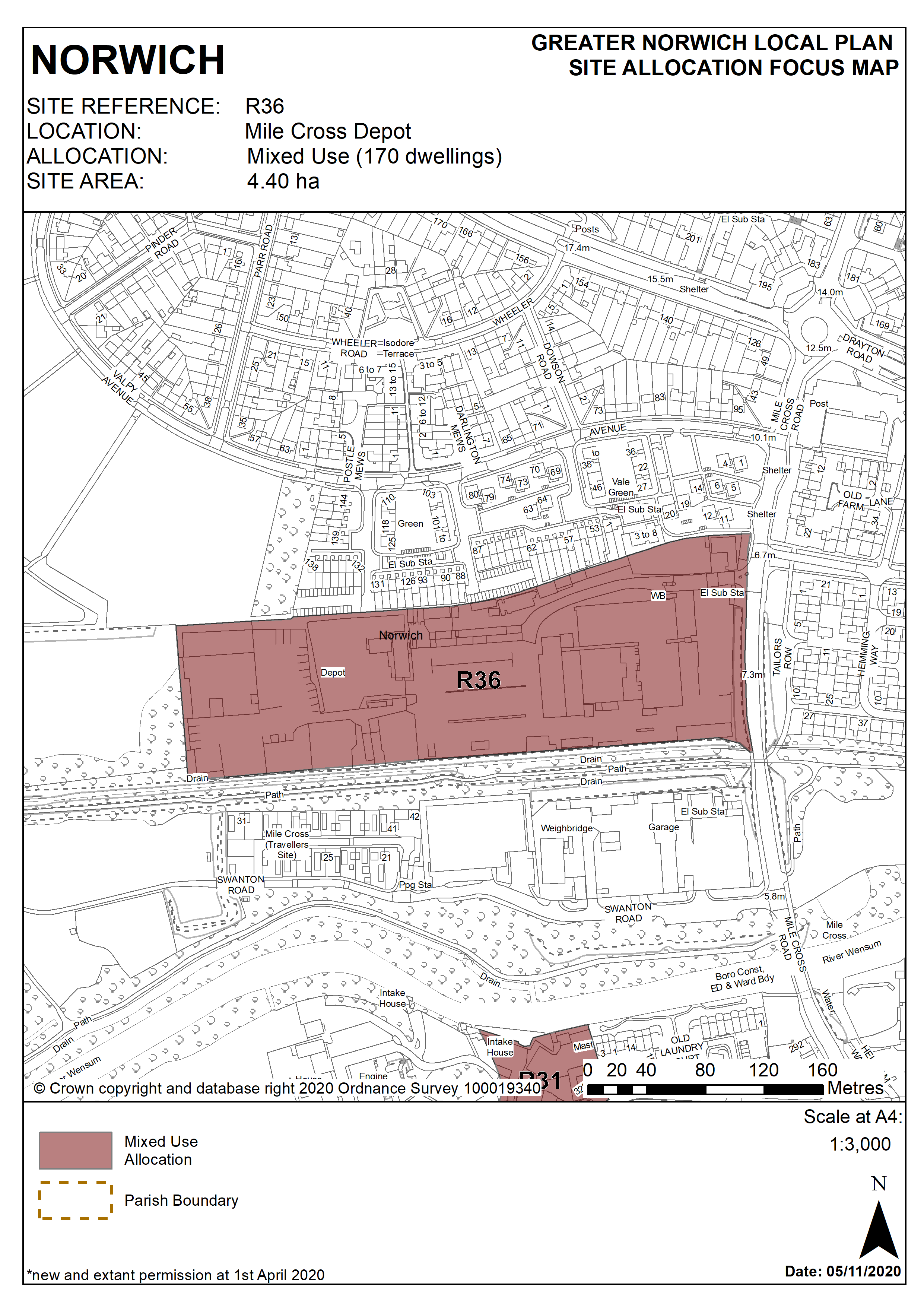
2.347
The former City Care Depot site is located in the west of the city and is 3.65 hectares in size.
2.348
The site was previously used as a council depot and was used for a variety of uses in conjunction with that use. It has recently been cleared in preparation for development. The previous uses of the site included offices, vehicle repair workshops and storage.
2.349
The site is close to existing residential developments at Valpy Avenue to the north and on the other side of Mile Cross Road. The site is largely flat and the site level rises significantly to the north. The railway path (part of Marriot’s Way) runs along the southern boundary of the site which is also a key cycle route and part of the green link network. Adjacent to the site on the far side of the railway path are recycling centres (pending relocation), business buildings and the Gypsy and Traveller site at Swanton Road.
2.350
This surrounding area is dominated by a mixture of industrial and residential uses. The industrial areas are however fragmented and are increasingly being redeveloped for housing. Mile Cross Road is part of the major road network and is a radial road to the west of the city.
2.351
This allocation provides an opportunity to make more efficient use of the former City Care site, providing opportunities for housing development and associated community uses.
2.352
The loss of some employment land on the site will be compensated for by the wider regeneration benefits to this part of the city through a comprehensive housing scheme and create enhancements of and better access to green infrastructure within this area.
2.353
The development will need to overcome a number of constraints. The site is adjacent to the valley of the River Wensum which is an important environment asset. It is also close to the Sweet Briar Road Meadows which a Site of Special Scientific Interest. Development proposals should be designed to preserve and enhance biodiversity.
2.354
There are a number of trees and habitats adjacent to the site which should be protected and enhanced.
2.355
The site is partially covered by Flood Zone 2 and is greater than 1 hectare in size; it therefore requires a flood risk assessment and appropriate mitigation measures should be provided as part of the development. Other constraints include possible contamination and possible ground condition issues.
2.356
Development proposals must take account of the site’s location within the consultation area for the Waste Transfer Station and Household Recycling Centre at Swanton Road, and location within the outer zone of the Health and Safety Executive consultation area for Heigham Waterworks and Bayer Crop Science. Site layout and disposition of uses should reflect this.
2.357
The adjacent railway path is a key element of the city’s cycling network; the design of development should be permeable, enabling pedestrian / cycle links through the site to connect with the route.
2.358
Mile Cross Road is already a busy road and not capable of handling significant increase in traffic from residential development. Access issues need to be addressed as part of a planning application.
2.359
The site is likely to accommodate a minimum of 170 homes. More may be accommodated, subject to an acceptable design and layout etc. being achieved, dependant on the mix of uses and geological constraints being overcome.
Policy R36
Mile Cross Depot, Norwich (approx. 4.40ha) is allocated for mixed use development with residential and associated community uses. This will accommodate a minimum of 170 homes.
The development will achieve the following site-specific requirements:
- Achievement of a high quality, locally distinctive design which reflects its prominent location on the edge of the river valley, the setting of the adjoining Mile Cross Conservation Area and the proximity of formal and informal recreational open space;
- High quality green infrastructure, landscaping, planting and biodiversity enhancements should be provided including formal and informal public and private open spaces within the site.
- The southern frontage of the site to Marriott’s Way should be enhanced and landscape and pedestrian and cycle links provided through the site to link with the existing recreational route;
- Potential contamination from existing and previous uses on site, potential geological issues and potential impacts of noise and odour generation from the recycling centre on Swanton Road (so long as it is retained) should be assessed and mitigated.
- Vehicular access should be taken from Mile Cross Road with emergency access and pedestrian/cycle links provided to Valpy Avenue
- Norfolk Minerals and Waste Core Strategy Policy CS16 applies, as this site is partially underlain by safeguarded minerals resources. The benefits of extracting the minerals, if feasible, will be taken into consideration. Parts of the site are within the consultation area for a safeguarded Waste management site and Norfolk Minerals and Waste Core Strategy policy CS16 applies, while the waste site is active.
Policy Map