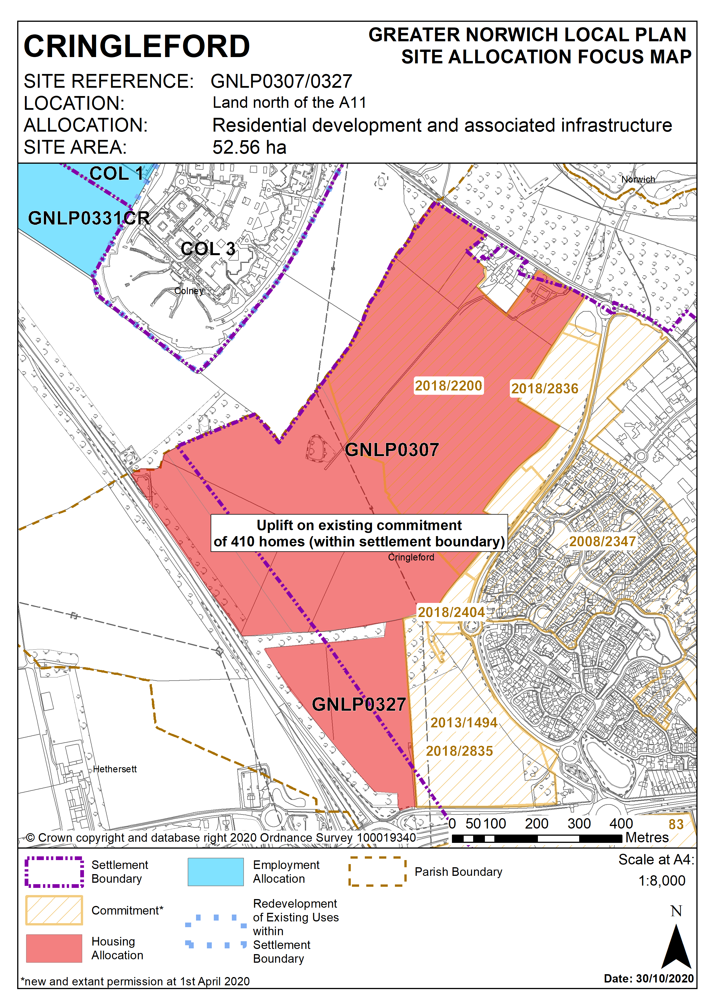
3.27
The Cringleford Neighbourhood Plan identified an area for approximately 1,200 new homes for which permissions are now in place (outline application references 2013/1494 and 2013/1793) for up to 1,300.
3.28
These permissions do not occupy the whole of the housing site allocation in the Neighbourhood Plan. The remaining area of land identified in the Neighbourhood Plan as suitable for development is located between the Norwich southern bypass Landscape Protection Zone (set out in the Neighbourhood Plan) and the edge of the permitted schemes. giving potential for further development beyond 2026. The uplift in housing on land allocated for development is estimated as an extra 410 dwellings on top of the 1,300 dwellings already permitted. In addition, both outline permissions make provision for a primary school site, but only that within outline 2013/1793 will be required. The primary school site within outline permission 2013/1793 is approximately 2 hectares, the identified housing uplift is likely to require a larger school site, to be accommodated on land adjoining the already identified site.
3.29
Site GNLP0307 is adjacent to a stream with a significant section of culverted watercourse (1.2km) in total. Opening up this stream again as well as any contribution towards enhancing the natural habitats of the Yare Valley would be supported by the Environment Agency.
3.30
Highways England has confirmed that it is likely that the proposed improvement of the A47 Thickthorn interchange will be able to accommodate the proposed uplift but this will need to be confirmed with a Transport Assessment.
Policy GNLP0307/GNLP0327 (Cringleford Neighbourhood Plan HOU1)
STRATEGIC ALLOCATION
Land north of the A11 (approx. 52.56 ha) is allocated for residential development and associated infrastructure. This will accommodate approximately 1,710 homes.
The development will be expected to address the following specific matters:
- Development to comply with the policies of the Cringleford Neighbourhood Plan 2013-2026, including that no more than approximately 1,300 homes are built prior to 2026.
- A Transport Assessment will be required, to include:
- confirmation that the proposed improvements to the A47 Thickthorn Interchange can accommodate the uplift in dwelling numbers;
- a vehicular route through the adjacent development site (reference: 2013/1494), capable of serving as a bus route;
- footpath and cycleway connections to the Roundhouse Way bus interchange;
- improvements to Colney Lane;
- enhanced pedestrian, cycle and public transport access to the wider Norwich Research Park (including the UEA);
- enhanced walking routes to nearby schools; and
- safeguarding of land for a pedestrian footbridge over the A47.
- Approximately 3 hectares of the site should be safeguarded for a new school, or equivalent alternative provision in agreement with the education authority.
- Adequate landscaping and green infrastructure to be provided including landscape buffer in accordance with Bypass protection zone adjacent of A47 and adequate noise mitigation measures to protect residential amenity.
- Inclusion of pollution control techniques to ensure that development does not lead to pollution of the water environment as the site falls within source protection zone 3.
- Historic Environment Record to be consulted to determine any need for archaeological surveys prior to development.
- Provision of a drainage system (SUDs).
- Mitigations to address utilities infrastructure crossing the site.
- Norfolk Minerals and Waste Core Strategy Policy CS16 applies, as this site is partly underlain by safeguarded minerals resources. The benefits of extracting the minerals, if feasible, will be taken into consideration.
Policy Map