2.72
Anglia Square is a 1960s neighbourhood shopping precinct, forming the main part of the large district centre in the north of the city centre. This site is a major regeneration priority. The capacity of Anglia Square to deliver a significant element of the plan's housing need on a highly accessible brownfield site means that it has strategic significance for Greater Norwich. The Employment, Town Centre and Retail Study (GVA, 2017) acknowledges the considerable potential of Anglia Square to accommodate a much-enhanced retail and leisure offer including extensive public realm improvements.
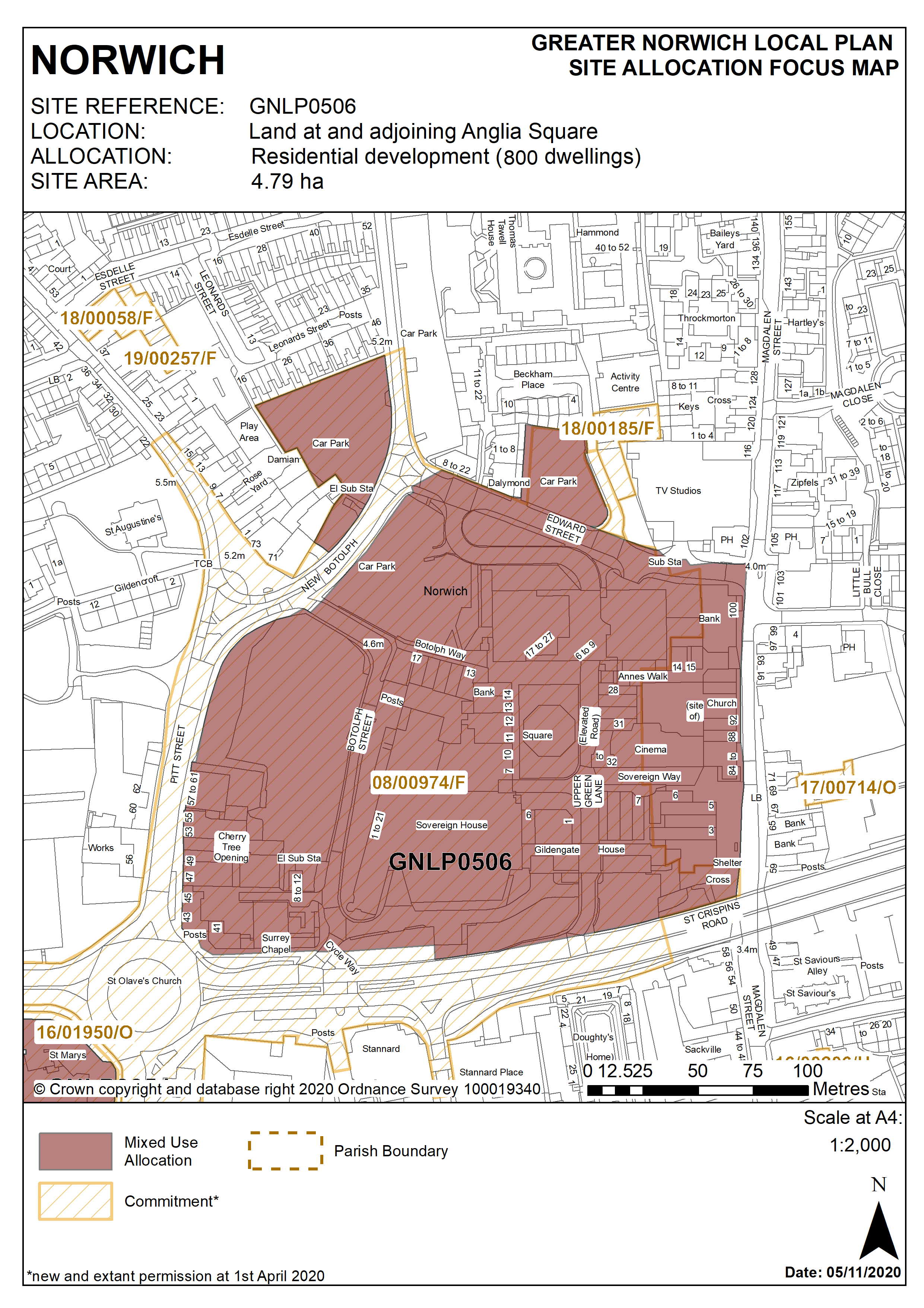
2.73
Development of the site must address a number of constraints including its location within the City Centre Conservation Area and the Area of Main Archaeological Interest, critical drainage catchment area, the relationship with neighbouring statutory and locally listed buildings, site ground conditions, its prominent location at gateways to the city, removal of the derelict and long-term vacant buildings from the site, transport infrastructure. A noise impact assessment and air quality assessment will be required, and the development must be designed to mitigate the impact of noise from the main road.
2.74
The site is likely to accommodate in the region of 800 homes, a significant proportion of which will be affordable, although the precise level will need to be the subject of further detailed viability assessment. It will also provide a mix of affordable tenures consistent with identified needs at the time of submission of a planning application. Anglia Square should retain its position as part of a defined large district centre, complementing the city centre retail offering.
Policy GNLP0506
Land at and adjoining Anglia Square, Norwich (approx. 4.79 hectares) is allocated for residential-led, mixed-use development as the focus for an enhanced and improved large district centre and to act as a catalyst for wider investment and redevelopment within the Northern City Centre strategic regeneration area as defined in policy 7.1 of this plan.
The site will deliver in the region of 800 homes.
The development will achieve the following site-specific requirements:
- Delivery of a comprehensive, mixed use regeneration scheme which can include residential development, student accommodation, retail units contributing to the Magdalen Street/Anglia Square large district centre, offices and flexible workspace, hotel, leisure and hospitality uses and community facilities as part of a balanced mix;
- Phasing (where appropriate) to be agreed;
- A significantly improved retail/leisure offer providing a continuous active frontage between Magdalen Street and St Augustine’s Street
- Removal of the derelict and long-term vacant buildings from the site, including Sovereign House and the existing multi-storey car park
- Delivery of replacement high quality decked public car parking to serve the large district centre;
- Achievement of high quality, locally distinctive and energy efficient design with scope for a landmark building or buildings providing a new focal point for the Northern City Centre and sited to conserve and enhance the significance of heritage assets and their settings;
- Conserve and enhance the significance of the City Centre Conservation Area and nearby listed buildings at Magdalen Street, Doughtys Hospital, Doughtys Cottages, St Augustine’s Street (including grade I listed Church of St Augustine), Gildencroft, including any contribution made to their significance by setting.
- High quality landscaping, planting and biodiversity enhancements;
- Low-car or car-free housing where consistent with scheme viability;
- A noise impact assessment and air quality assessment will be required, and the development must be designed to mitigate the impact of noise from the main road;
- Significant improvements in connectivity and permeability across the site to deliver new and enhanced pedestrian and cycle links north-south between Edward Street and St Crispin’s Road, and east-west between Magdalen Street and St Augustine’s and improved integration with the surrounding network;
- High quality public realm improvements creating attractive, legible and user-friendly streets and public spaces both within the site and adjacent to it on Magdalen Street (including land under the flyover)
- A mobility hub featuring shared transport services (buses, car club and bike share) centred on Magdalen Street in the vicinity of the flyover that is easily accessible on foot and by bicycle to promote use of sustainable transport modes by residents, visitors and other users;
- Heritage interpretation measures to be incorporated in accordance with Policy 3 of this plan.
Policy Map