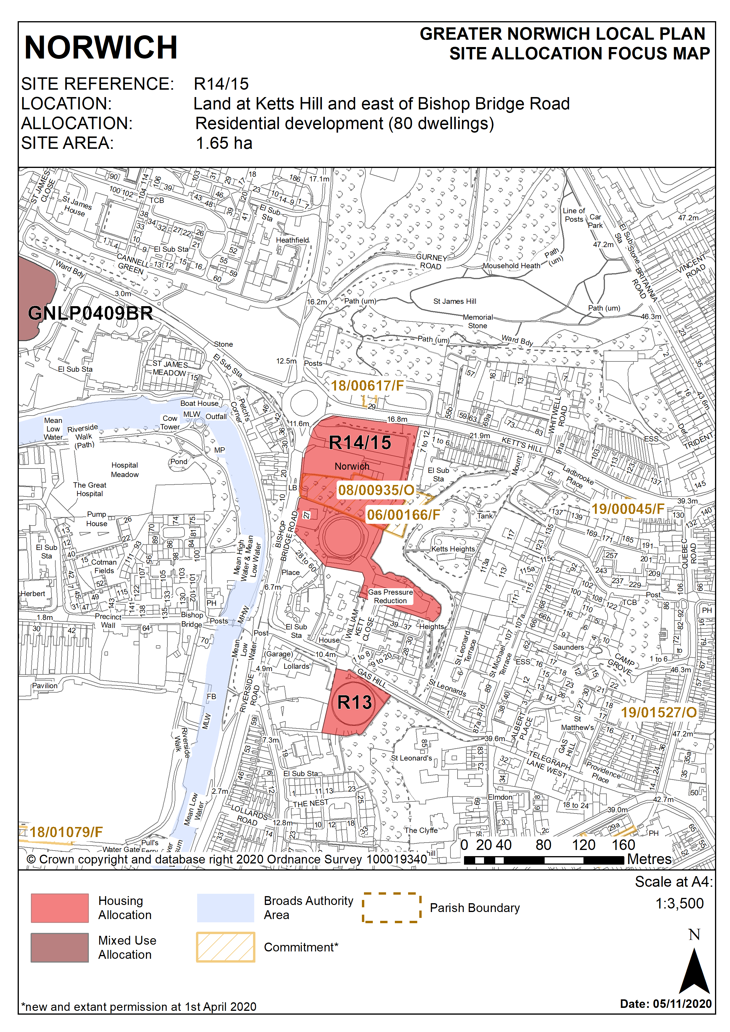
2.279
The site was previously identified as two separate allocations in the adopted ‘Site allocations and site-specific policies’ plan, site R14 (Land East of Bishop Bridge Road) and R15 (Land at Ketts Hill and Bishop Bridge Road). The majority of the site still falls within a HSE Hazardous Installation Consultation Zone which is centred on the former gas storage site. As part of any future application it should be demonstrated that National Grid has surrendered or revoked the Hazardous Substance Consent. The site has not yet been developed. The principle of residential development on the land has already been accepted and it is expected that development will take place within the time-period of this Local Plan. The sites are accordingly re-allocated for residential development as a single allocation for a similar number of homes. The potential contribution from the previous allocations has been considered in the calculation of the housing requirement.
2.280
Development should respect the heritage significance and setting of the adjacent Thorpe Hamlet, City Centre and St Matthews Conservation Areas . Design will have to take account of the site’s topography and must not have a negative impact on geodiversity or on views to and from the Thorpe Ridge - Kett’s Heights is identified as an important long view in appendix 8 of the DM policies plan and the site lies between two conservation areas; 19th Century walls on the Box and Barrell land are highlighted as of importance in the conservation area appraisal. If possible these should be retained as part of any future development. Kett’s Heights is also identified as part of a green infrastructure corridor. Therefore the design of development must take account of existing trees on site and create a habitat link to Kett’s Heights. The trees along the Ketts Hill site frontage are subject to a Tree Preservation Order (TPO) No 430. These trees will need to be retained as part of any proposal and it should be demonstrated that they can be protected during the works. Tree cover also extends from the escarpment into the site and it is considered that this tree cover provides a visually soft transition between the nature geographic feature of the escarpment and the flatter areas of the river valley. This valuable woodland edge forms a key part in the conservation area and consideration would have to be given to what impact the proposed development would have on the woodland edge (and vice versa). Provision for an additional access to Kett’s Heights through the allocation site should be provided. There will need to be an assessment of the levels and trees in this part of the site as it slopes up steeply from west to east, there is also gas infrastructure to consider, this will determine the best route into the site to link with existing routes. Steps will likely be required and should be of a durable construction such as UV stable recycled composite plastic, backfilled with Type 1 and with a hoggin surface. A handrail will be required and fencing may be required in some areas. Access should be gated to enable locking at dusk in line with other existing access points. A commuted sum would be required for maintenance of this access route.
2.281
The development will also have to address specific on-site constraints relating to its former uses and location. Decommissioning and demolition of existing structures will be required and ground conditions and contamination assessments will be necessary. A noise impact assessment will be required and design of the development must minimise the impact of noise from the inner ring road. An archaeological assessment will also be required.
2.282
Access to the majority of the site should be from the existing unused junction neighbouring 27 Bishop Bridge Road. Since this access point is likely to also be used to access site R15 to the north, development should be designed to enable this. Inclusion of the gas pressure reduction station means that the south-eastern part of the development could be accessed via William Kett Close.
2.283
As a minimum, protection and enhancement of geodiversity will include recording of geological features on site.
2.284
Development needs to ensure that the water environment is protected. The site falls within Source Protection Zone 1, designated to protect water supplies, and therefore the water environment is particularly vulnerable in this location. Detailed discussions over this issue will be required with the Environment Agency to ensure that proposals are appropriate for the site and that the site is developed in a manner which protects the water environment. The site is served by an on-site combined foul and surface water sewer. Adoption of this facility into a proposed drainage strategy must be pre-agreed with the appropriate management company.
2.285
The site is likely to accommodate a minimum of 80 homes. More may be accommodated, subject to an acceptable design and layout etc. being achieved.
Policy R14/15
Land at Ketts Hill and east of Bishop Bridge Road, Norwich (approx. 1.65ha) is allocated for residential development. This will accommodate a minimum of 80 homes.
Site R15 combined with R14 as a single allocation.
The development will achieve the following site-specific requirements:
- Achievement of a high quality, locally distinctive design of a scale and form which reflects and responds to its prominent location adjacent to the hillside east of the city centre and to Thorpe wooded ridge.
- Development should respect the heritage significance and setting of the adjacent Thorpe Hamlet, City Centre and St Matthews Conservation Areas
- Consider long views and vistas particularly taking into account key landmark buildings. Examples of important views are from Mousehold Heath and Ketts Height and the view of the Cathedral when coming down Kett’s Hill.
- Provide public access to Kett’s Heights
- Protection and enhancement of key green infrastructure, biodiversity and geodiversity assets within the site including retention and enhancement of tree planting to its northern boundary fronting Ketts Hill;
- Site contamination arising from the former gas storage use should be addressed and mitigated.
- Development will not take place prior to the revocation of the hazardous substance consent.
- The main vehicular access will be provided from Bishop Bridge Road.
- Car free development in accordance with Policy 2 is appropriate in this location.
Policy Map