2.231
The site was allocated in the previous Local Plan but has not yet been developed. The principle of development on the site has already been accepted, and it is expected that development will take place within the new local plan time-period up to 2038. The site is re-allocated for residential development. As an existing allocation it has been considered in the calculation of the housing requirement.
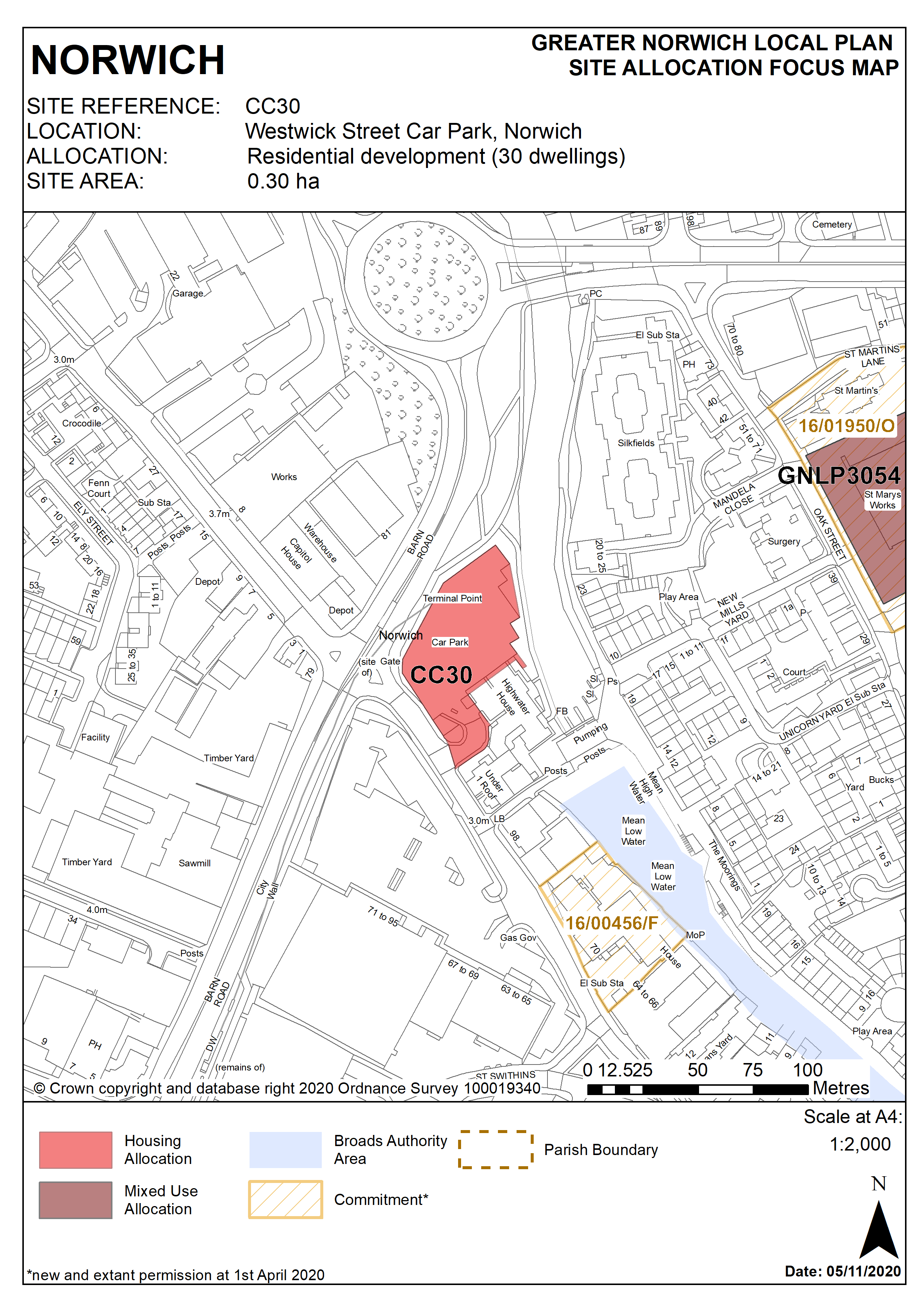
2.232
This 0.3 hectare site is currently occupied by a surface car park accessed from Westwick Street, a route into the city centre from the inner ring road. It is bordered by the ring road to the north and west, by the River Wensum and the riverside walk to the east and by a residential night shelter to the south-east. Parking for neighbouring retail units is to the south.
2.233
The site is a gateway to the city centre, located adjacent to the remains of the city wall, close to the former Heigham Gate and the former City Station.
2.234
Redevelopment of the site offers the opportunity to make better use of this valuable city centre site to continue the development of a vibrant mixed use quarter providing further housing in Westwick Street, and to extend the riverside walk.
2.235
As a main gateway, the quality of buildings here has a major impact on impressions of the city centre. High density development would be appropriate on the site, possibly of 3 or 4 storeys fronting Barn Road but stepping down to 2 or 3 adjacent to Highwater House and the river. A prominent corner building may be appropriate as part of a development scheme.
2.236
Development should address the site’s constraints. The site should be designed to take account of the height of neighbouring buildings and views of churches from the Barn Road roundabout. As the line of the former city wall runs across part of the site, this should be demarcated.
2.237
The City centre conservation area appraisal identifies the river and the riverside walk to the east of the site as providing positive vistas. Development should retain and if necessary improve footways around the site, linking to the neighbouring pedestrian and cycle network, and investigate the possibility of extending the riverside walk so that there is direct access to New Mills Yard. The development should seek to enhance the security and setting of the riverside walk.
2.238
New Mills Pumping Station near the site is grade II listed. Given its location adjacent to the remains of the city wall, a Scheduled Ancient Monument, the site may have archaeological interest; therefore an archaeological assessment is required prior to development on this site. Appropriate historic interpretation information should be incorporated in the development.
2.239
Development proposals will need to take account of noise from the neighbouring inner ring road; a noise assessment is required to inform the layout and design specification of development. Vehicular access should be from Westwick Street only and should take account of access to the Cathedral Retail Park opposite and the junction of Barn Road.
2.240
The site lies adjacent to the River Wensum. It is recommended that developers engage in early discussions with the Environment Agency.
2.241
The site is within Flood Risk Zone 2, therefore a flood risk assessment will be undertaken for this site and appropriate mitigation measures should be provided as part of the development.
2.242
The site lies within a Critical Drainage Catchment. Therefore development proposals involving new buildings, extensions and additional areas of hard surfacing should ensure that adequate and appropriate consideration has been given to mitigating surface water flooding.
2.243
Given the site’s location adjacent to the inner ring road and proximity to Grape’s Hill, which has acknowledged air quality issues, an air quality assessment will be required prior to development.
2.244
The site is likely to accommodate a minimum of 30 homes. More may be accommodated, subject to an acceptable design and layout etc. being achieved.
Policy CC30
Westwick Street Car Park, Norwich (approx. 0.30ha) is allocated for residential development. This will accommodate a minimum of 30 homes.
The development will achieve the following site-specific requirements:
- Achievement of a high quality, locally distinctive, and flood resilient design of a scale and form which has regard to its prominent gateway location within the City Centre
- Conserve and enhance the setting of the City Wall scheduled monument, adjacent grade II listed pump house (including any contribution made to their significance by setting). Scale and massing of the proposed development will enhance key views from and into the City Centre Conservation area
- Provide linkages through the site to the adjoining pedestrian network, including a connection with the riverside walk in accordance with policy 7.1 and the ‘River Wensum Strategy’
- Vehicular access should be taken solely from Westwick Street
- Heritage interpretation, particularly of the city wall, to be provided on site.
Policy Map