2.216
The site was allocated in the previous Local Plan but has not yet been developed. The principle of development on the site has already been accepted, and it is expected that development will take place within the new local plan time-period up to 2038. The site is re-allocated for mixed-use development. As an existing allocation it has been considered in the calculation of the housing requirement.
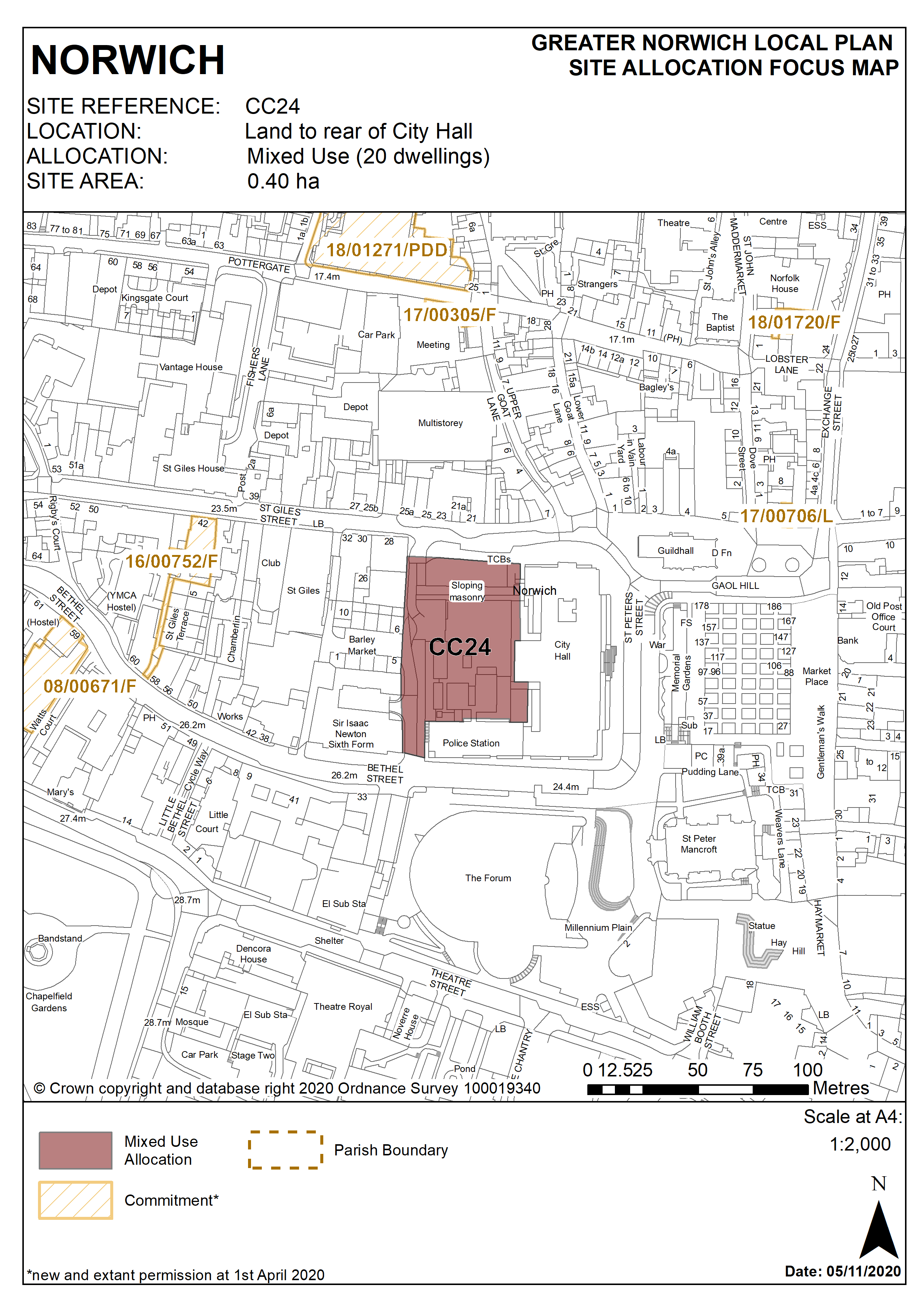
2.217
The former City Hall car park site is located to the rear of City Hall and is 0.4 hectares in size. The site was previously used as a surface car park and is currently used by Norfolk Constabulary for parking and other police activities.
2.218
This open site is dominated by large scale civic buildings. There is some relatively recent housing to the west, whilst St Giles Street to the north retains its mixed historic character. There are green areas and mature trees on the site’s northern boundary. The site is in the city centre Conservation Area, the Area of Main Archaeological Interest, and is surrounded by listed buildings.
2.219
The immediate surroundings of the site contain main public buildings forming the civic heart of Norwich. These include the Police Station and former Fire Station, the refurbished market place, and the Forum building. There is easy pedestrian access to the site.
2.220
City Hall has a positive frontage which not only fronts onto St Peters Street but also wraps around onto Bethel Street and St Giles Street.
2.221
Land to the rear of City Hall currently contributes very little to the conservation area and the redevelopment of the site has the opportunity to improve the streetscape.
2.222
The original intended plan for City Hall was for there to be a wing on St Giles Street and there is a strong argument for building this wing in order to create a street frontage to St Giles, a courtyard behind the building and a symmetrical arrangement that focuses on the projecting element of City Hall that contains the Council Chamber and is adorned by the three Alfred Hardiman sculptures.
2.223
The redevelopment of land to the rear of City Hall offers the potential to create an attractive new courtyard. This space should be open to the public and new routes should be created through the space to enhance permeability. For example a new route could be created from St Giles Street at the junction with the existing part of City Hall diagonally through the courtyard to Bethel Street opposite William Kemp Way which will help improve pedestrian links. If the police compound is needed to be retained then this could be done through the provision of a decked landscaped area above.
2.224
Development should address a number of constraints, including its location within the city centre Conservation Area and the Area of Main Archaeological Interest, potential contamination, trees on the northern part of the site, topography, access, the setting of listed buildings, and its relationship with neighbouring housing development. Any development must be clearly based on a heritage assessment informed by the 2005 Conservation Management Plan for the building.
2.225
Any loss of green space on St Giles Street would have to be mitigated and there would be a need for replacement planting for the loss of any trees.
2.226
Development may require the demolition of existing on-site structures. Its design must respect and enhance the adjacent City Hall and Police Station building which is grade II* listed. There are significant opportunities to enhance views into and across the site.
2.227
The site is adjacent to the core pedestrian network, therefore development should seek to enhance the existing north-south pedestrian link between St Giles Street and Bethel Street. The site is suitable for car free development.
2.228
The site is currently below surrounding ground levels. Given the significant change in topography across the site, it may be necessary to raise the ‘active’ parts of the development to above existing ground levels. This could present an opportunity to provide basement car parking or residential / commercial storage, subject to careful designs for access provision.
2.229
The site may accommodate at least 20 homes if developed for a mix of uses including residential. More may be accommodated, subject to an acceptable design and layout etc. being achieved.
Policy CC24
Land to rear of City Hall, Norwich (approx. 0.40ha) is allocated for mixed use development which may include residential, offices and managed workspace, food and drink and small-scale retail uses. The alternative option of a hotel development is supported and, if this option is progressed, scope for accommodating residential uses on part of the site should be investigated in order to retain its potential for housing delivery. If developed with an element of residential uses the site could accommodate a minimum of 20 homes.
The development will achieve the following site-specific requirements:
- Achievement of a high quality, locally distinctive and flood resilient design of a scale and form which has regard to its prominent location within the City Centre Conservation Area, the significance of adjoining heritage assets and their settings, and its position forming part of the setting of the immediately adjoining Grade II star listed City Hall.
- Development should take account of and respect the original design concept of City Hall and its intended architectural context within a wider planned civic centre. Development must be of an appropriate scale and massing and must be subservient to the main body and façade of City Hall. Therefore it is important that any new building does not exceed the height of City Hall (include any parapet concealing rooftop plant).
- If redevelopment involves the loss of trees on the St Giles Street frontage, the development should provide high quality green infrastructure, landscaping, planting and biodiversity enhancements;
- Any development must be clearly based on a heritage assessment informed by the 2005 Conservation Management Plan for the building.
- Any loss of green space on St Giles Street would have to be mitigated and there would be a need for replacement planting for the loss of any trees.
- The scheme should deliver improved connectivity between the Forum and Norwich Lanes by improving and enhancing the north-south pedestrian route between St Giles Street and Bethel Street.
Policy Map