2.160
The site was allocated in the previous Local Plan but has not yet been developed. Demolition of subsidence damaged bungalows previously on the site has been taken account of in the calculation of historic housing delivery. The principle of housing redevelopment on the site has already been accepted, and it is expected that development will take place within the new local plan time-period up to 2038. The site is re-allocated for residential development. As an existing allocation it has been considered in the calculation of the housing requirement.
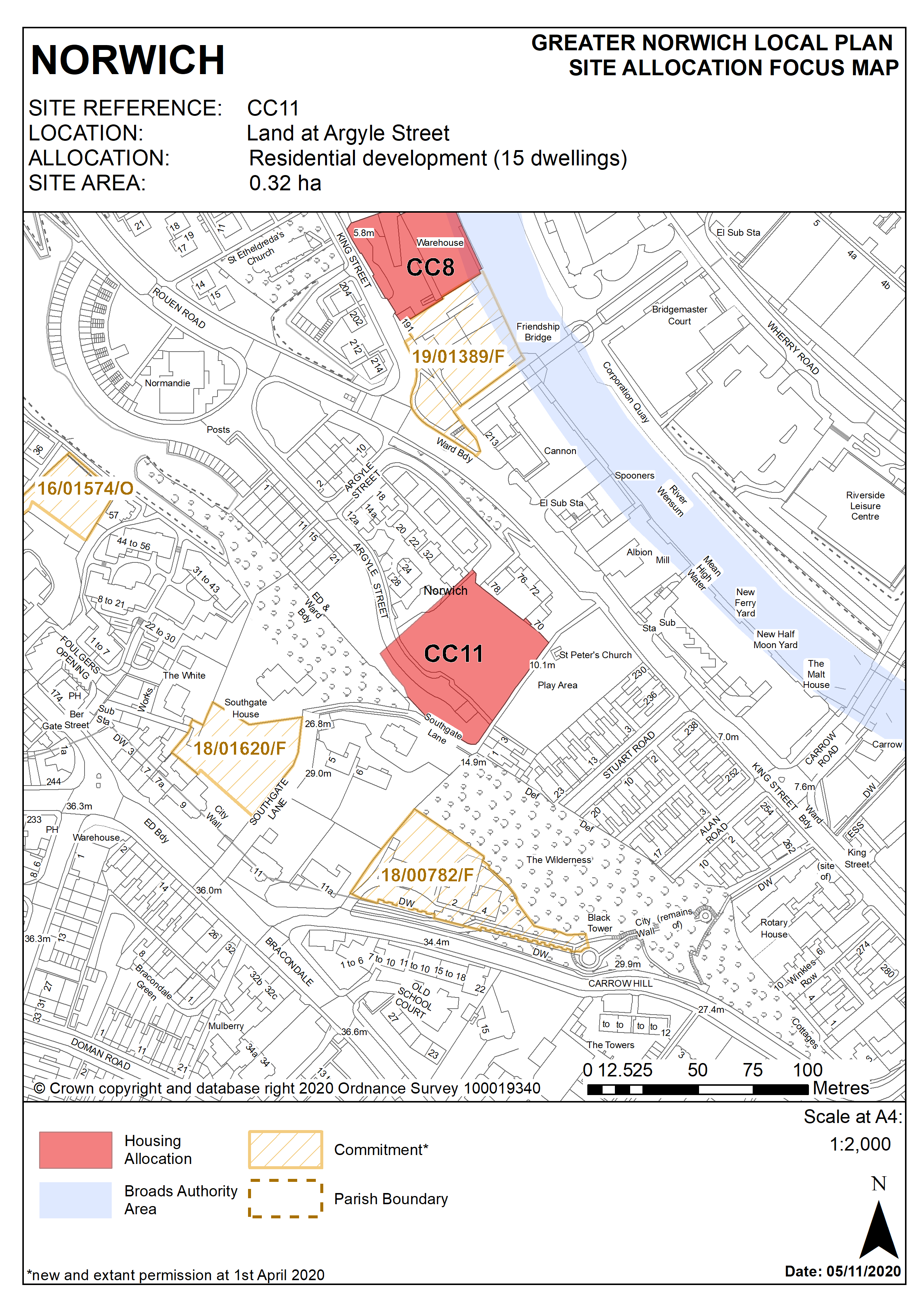
2.161
The site is located in the southern part of the city centre and is 0.32 hectares in size.
2.162
The site is adjacent to a housing area to the north and neighbours the remains of St Peter Southgate Church (grade II listed) and its former churchyard, which is a designated public urban green space with play equipment. It is also adjacent to the Ber Street wooded ridge on its south-western boundary.
2.163
Argyle Street is in the Rouen Road/King Street area and is covered by King Street section of the City centre conservation area appraisal. The area is undergoing significant change and many former industrial buildings close to the river have been replaced or converted to residential uses. The wooded ridge which runs from Thorn Lane to Argyle Street forms an important ecological link within the city centre and extends along the south of the site through the historic churchyard.
2.164
The allocation of this site for housing development will bring it back into use and help regenerate this part of the King Street area.
2.165
Development must address the site’s constraints. The site’s history of subsidence means that future development must address the ground condition issue requiring significant ground conditions investigations and any necessary mitigation prior to development.
2.166
Development should have regard to the City centre conservation area appraisal.
2.167
The wooded ridge should be protected and development should seek to enhance the green corridor network which runs adjacent to the site.
2.168
An archaeological investigation will be required.
2.169
Development needs to ensure that the water environment is protected throughout the development of the site. The site falls within Source Protection Zone 1, designated to protect water supplies, and therefore the water environment is particularly vulnerable in this location. Detailed discussions over this issue will be required with the Environment Agency to ensure that proposals are appropriate for the site and that the site is developed in a manner which protects the water environment.
2.170
The site is likely to accommodate approximately 15 homes. This will include affordable housing providing a mix of affordable tenures consistent with identified needs at the time of submission of a planning application and subject to viability, but it is expected that as the land is in public ownership the site is capable of delivering a scheme of 100% affordable dwellings.
Policy CC11
Land at Argyle Street, Norwich (approx. 0.32ha) is allocated for residential development. This will accommodate approximately 15 homes.
The development will achieve the following site-specific requirements:
- The design of development must respect the adjacent wooded ridge and seek to enhance the green corridor network which runs adjacent to the site; conserve and enhance the significance of the City Centre Conservation Area and nearby statutory and locally listed buildings (specifically the remains of grade II listed St Peter Southgate church) (including any contribution made to their significance by setting)
- Potential ground stability issues should be addressed in the design and configuration of new housing, with scope for the use of dwelling types employing lightweight modular construction.
Policy Map