Chapter contents
- POLICY NCC.01 and NCC.02 Land at Barrack Street/Whitefriars, Norwich
- POLICY NCC.03 and NCC.04 Land at Rose Lane/Mountergate, Norwich
- POLICY NCC.05 Norwich Mail Centre, 13-17 Thorpe Road, Norwich
- POLICY NCC.06 Land adjoining Norwich City Football Club north and east of Geoffrey Watling Way, Norwich
- POLICY NCC.07 Land at Argyle Street, Norwich
- POLICY NCC.08 King Street Stores, Norwich
- POLICY NCC.09 Hobrough Lane, King Street, Norwich
- POLICY NCC.10 Land at Garden Street and Rouen Road, Norwich
- POLICY NCC.11 10 – 14 Ber Street, Norwich
- POLICY NCC.12 Land adjoining Sentinel House (St Catherine’s Yard), Surrey Street, Norwich
- POLICY NCC.13 Land to rear of City Hall, Norwich
- POLICY NCC.14 The Former Eastern Electricity Headquarters, Duke’s Wharf, Duke Street, Norwich
- POLICY NCC.15 Land adjacent to the River Wensum and the Premier Inn, Duke Street, Norwich
- POLICY NCC.16 Friars Quay Car Park, Colegate, Norwich
- POLICY NCC.17 Land at and adjoining St Georges Works, Muspole Street, Norwich
- POLICY NCC.18 Westwick Street Car Park, Norwich
- POLICY NCC.19 Site at St Mary’s Works and St Mary’s House, Norwich
- POLICY NCC.20 Land at 150-154 Oak Street and 70-72 Sussex Street, Norwich
- POLICY NON.01 Land at Holt Road, Norwich
- POLICY NON.02 Two sites at Hurricane Way, Airport Industrial Estate, Norwich
- POLICY NON.03 Land at Constitution Motors, 140-142 Constitution Hill, Norwich
- POLICY NON.04 Land north of Windmill Road, Norwich
- POLICY NON.05 Site of former Start Rite Factory, 28 Mousehold Lane, Norwich
- POLICY NON.06 Site of former Van Dal Shoes, Norwich
- POLICY NON.07 Land east of Starling Road, Norwich
- POLICY NON.08 Heigham Water Treatment Works, Waterworks Road, Norwich
- POLICY NON.09 Mile Cross Depot, Norwich
- POLICY NOS.01 The Norwich Community Hospital site, Bowthorpe Road, Norwich
- POLICY NOS.02 Site of former Earl of Leicester Public House, 238 Dereham Road, Norwich
- POLICY NOS.03 Land at Kett’s Hill and east of Bishop Bridge Road, Norwich
- POLICY NOS.04 Site of former Gas Holder at Gas Hill, Norwich
- POLICY NOS.05 Land west of Eastgate House, Thorpe Road, Norwich
- POLICY NOS.06 John Youngs Limited, 24 City Road, Norwich
- POLICY NOS.07 Land at The Neatmarket, Hall Road, Norwich
- POLICY NOS.08 Land west of Bluebell Road, and north of Daisy Hill Court/Coralle Court, Westfield View, Norwich
- UEA POLICIES
- POLICY NOS.09 Land adjoining the Enterprise Centre at Earlham Hall (the walled garden and nursery), Norwich
- POLICY NOS.10 Land north of Cow Drive (the Blackdale Building, adjoining Hickling House and Barton House), at the University of East Anglia, Norwich
- POLICY NOS.11 Land between Suffolk Walk and Bluebell Road
- POLICY NOS.12 Land at the UEA Grounds Depot Site, Bluebell Road University of East Anglia – strategic reserve
Introduction
3.1 The Norwich urban area is at the top of the GNLP settlement hierarchy. As the most accessible and sustainable location in the area, Norwich benefits from a high level of accessibility to a broad range of local and sub-regional services and facilities. In this local plan, Norwich will retain that prime position and be promoted for a significant share of housing and economic development in the GNLP. The area within the city boundary is largely built-up and no large-scale greenfield sites remain available to allocate. Therefore, Norwich’s potential for the delivery of new housing and economic development will be reliant on the use of previously developed land and premises, increasing densities and housing-led regeneration and renewal, particularly in the city centre.
Important considerations
3.2 Norwich has many assets like open spaces, green infrastructure and the river valleys of the Wensum and Yare. The landscape setting of Norwich and the proximity of the Broads are other considerations. All these assets will limit the scale and location of development in Norwich. The major heritage significance of parts of the city mean that particular care needs to be taken in planning, locating and designing new development.
3.3 All allocations are expected to address standard requirements associated with development. These vary from place to place but are likely to include mitigation for flood risk (as well as SUDs), highway improvements, safeguarding of minerals resources, land remediation, and measures to protect the environment and biodiversity and avoid landscape intrusion.
Numbers of new homes in Norwich
3.4 As set out in the housing table in policy 7.1, 6,545 homes were either delivered in Norwich between the plan’s base date of 1st April 2018 and 31st March 2022 or were planned to be delivered on already committed sites. Including the strategic sites at East Norwich (STR.01) and Anglia Square (STR.02), there are new allocations and changes to existing allocations providing for 4,178 new homes. This gives a total deliverable housing commitment in policy 7.1 for Norwich of 10,723 homes.
Meeting the development needs in Norwich
3.5 The plan both includes some completely new allocations and allows for the considerable potential to increase housing densities on previously identified sites, particularly in and adjoining the city centre. The city centre will also be a focus for employment, retail, leisure, educational and cultural facilities.
3.6 The plan includes a limited number of allocations for employment use and other uses carried forward from previous local plans: this includes three sites providing for the longer-term expansion of the University of East Anglia.
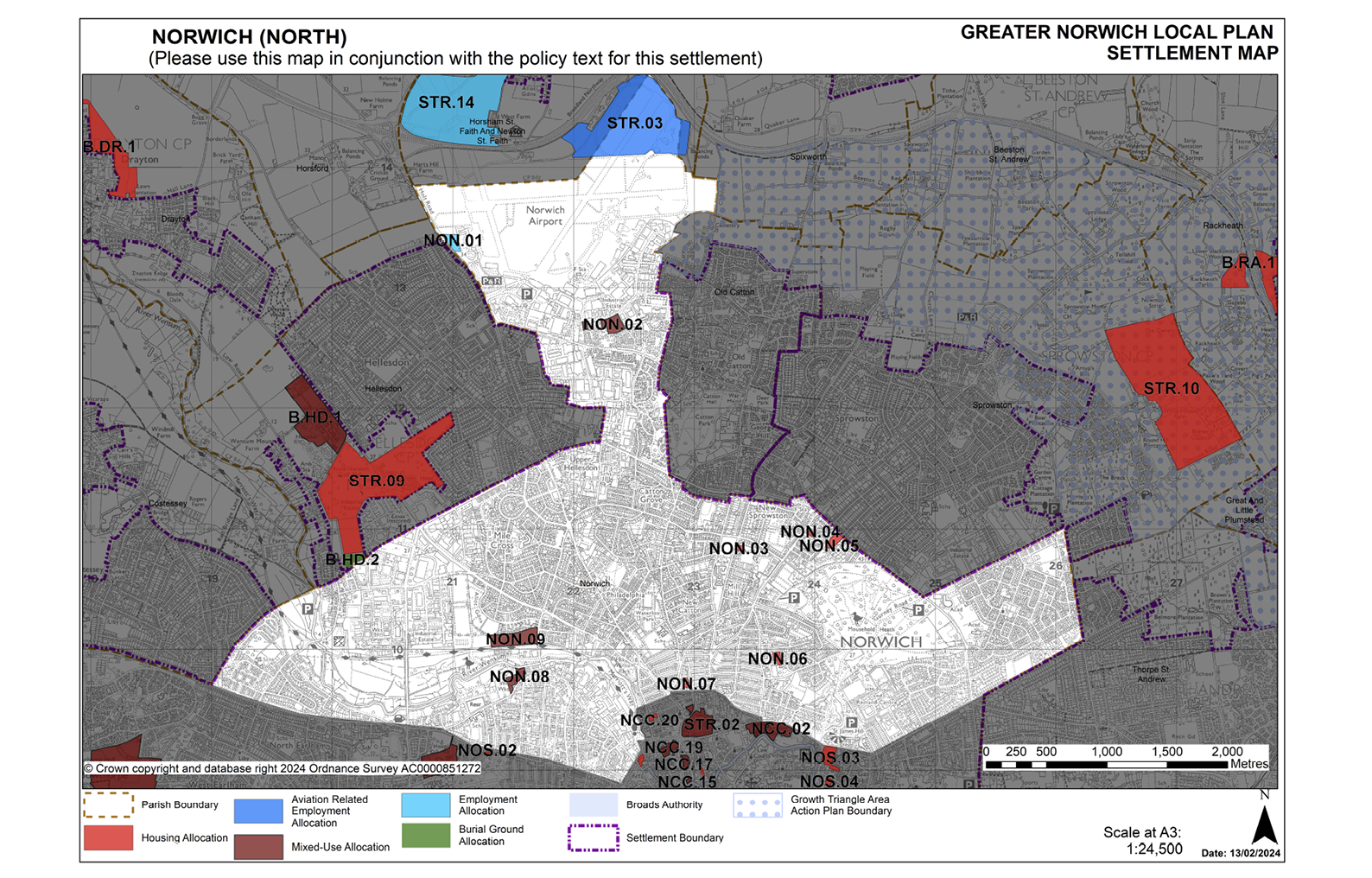
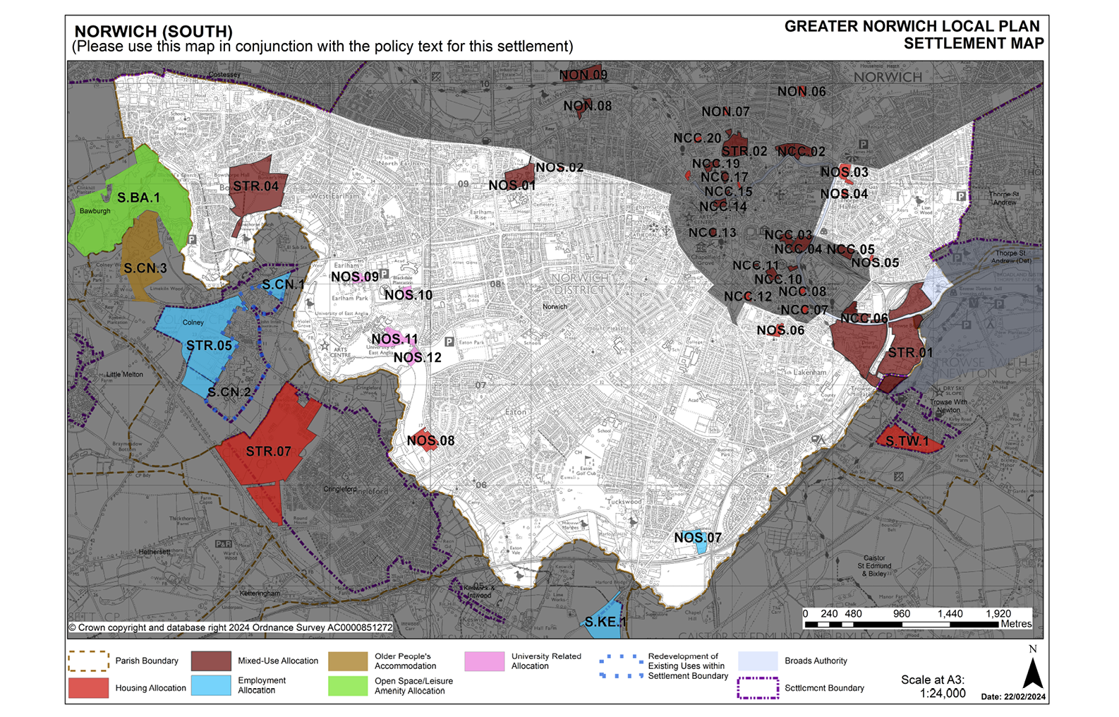
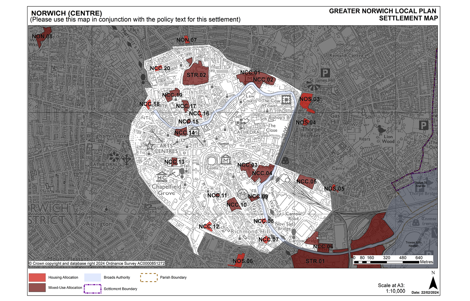
STRATEGIC SITE ALLOCATIONS IN NORWICH
3.7 The policy and supporting text for the following site allocations in Norwich can be found in the strategic sites section at the beginning of the Sites Plan:
- STR.01 East Norwich Strategic Regeneration Area (ENSRA), Norwich.
- STR.02: Land at and adjoining Anglia Square, Norwich
- STR.03: Land known as ‘Site 4’ at Norwich Airport, Norwich.
- STR.04: Three Score, Bowthorpe, Norwich.
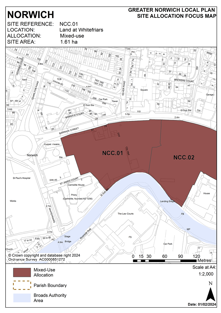
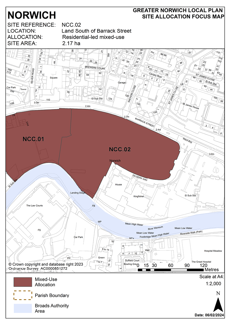
POLICY NCC.01 and NCC.02
Land at Barrack Street/Whitefriars, Norwich
3.8 Land allocated at Barrack Street/Whitefriars was formerly the site of the Jarrolds printworks and neighbouring flats. Land in the east of the site is currently used as a temporary surface car park. The site is allocated in two parts in this plan.
3.9 The western section of the site, allocated as site NCC.01, is within the City Centre Conservation Area. It contains standing remains of the city wall scheduled monument, two Grade II listed cottages (77-79 Barrack Street) and two locally listed cottages. The site is situated within the area of main archaeological interest and has significant underground archaeological remains. Assessment will also be required of any archaeological interest which may remain on site NCC.02. It is important that the development protects and enhances the setting of the wall.
3.10 Development of these sites must be of a scale and form which respects and takes advantage of their riverside context and location in respect of the Broads. As the site lies adjacent to the River Wensum, it is recommended that developers engage in early discussions with the Environment Agency and the Broads Authority.
3.11 77 and 79 Barrack Street are Grade II listed early 19th century houses. They are one-up, one-down terraced housing which have been unsympathetically converted and extended at ground floor level. The properties are in a poor state of repair and are on Norwich’s buildings at risk register. They are rare survivors of one-up-one-down cottages and are reported to be the last in Norwich of this type. These cottages must be brought back into residential use and renovated to ensure their future and to remove them from the register.
3.12 There are a number of listed buildings within the vicinity which include St. James’ Mill, which is Grade I listed, the former church of St. James (now the Norwich Puppet Theatre), a 12/13th century undercroft at the junction of Whitefriars and St James’ Court and the remains of an anchorite house which was part of the Whitefriars monastery. Norwich Cathedral is located 330 metres to the south of the site.
3.13 The site previously included a mid-20th century annex which contained the Jarrolds Printing Museum which was founded in 1982. Whilst the loss of this utilitarian building is accepted, the private collection of artefacts must be recorded and some form of print museum re-provided on or off-site. Proposals will be required to adopt and implement a strategy of heritage interpretation relating to the former use of the site as a printworks;
3.14 Development should respect the build line of St. James’ Church and remain subordinate to the church. Development should complement St. James’ Mill in terms of height and scale and remain subservient to it.
3.15 There are trees situated along the northern, western and southern boundaries of the site. The site is within 500 metres of St. James’ Pit SSSI and Mousehold Heath which is a Local Nature Reserve and County Wildlife Site. Train Wood is a non-designated county wildlife site that is also situated within 1 kilometre of the site. Any loss of trees should be mitigated through replacement planting to help soften the development and to contribute towards replacement biomass.
3.16 A noise impact assessment and air quality assessment will be required as the site is situated on Norwich’s inner ring road and is located within the Central Norwich Air Quality Management Area.
3.17 The majority of the site is situated within flood zone 2 with a minor area being situated in flood zone 3. SUDs will need to be provided as part of the development.
3.18 There is potential for contamination and therefore ground investigation reports will be required.
3.19 There is an existing surface water sewer in Anglian Water’s ownership within the boundary of the site. This should be taken into account in the design of the development including safeguarding suitable access for maintenance.
POLICY NCC.01
Land at Whitefriars, Norwich (1.61 hectares) is allocated for residential-led mixed-use development. This will include approximately 220 homes. Offices and managed workspace, ancillary retail use, restaurants, bars, and recreational open space will be accepted as part of a balanced mix of uses.
The development will achieve the following site-specific requirements:
- Achievement of a high-quality, locally distinctive design of a scale and form which respects and takes advantage of its riverside context and location within and adjoining the City Centre Conservation Area. Design should distinguish between the areas within and outside of the city walls through layout, scale, height, use of materials and design detailing.
- There will be a general presumption in favour of the repair and reuse of heritage assets on-site as part of any site regeneration, however any application for redevelopment will be considered on its merit. Great weight will be given to the conservation of all designated heritage assets. Proposals will enhance the setting of the City Wall Scheduled Monument and the two listed cottages at 77-79 Barrack Street must be retained, brought back into residential uses, and renovated. Proposals should provide a suitable setting for designated heritage assets affected by the proposals on and off-site including key views from and into the site.
- Development proposals should draw upon local character and distinctiveness and conserve or, where opportunities arise, enhance the character and appearance of the conservation area.
- Ensure a high level of flood resilience and incorporate appropriate flood mitigation measures (including addressing identified risks from flooding from rivers and surface water flooding).
- Reintroduce a building line along Barrack Street and a frontage to the river; buildings fronting the river should respond to the height of the mill whilst remaining subservient to it.
- Reduced levels of residential car parking to achieve low car or car-free housing development in accordance with policy 2 Sustainable Communities is appropriate to be provided in this location.
- Maximises the views across, from and of the river. Retain the existing embankment line and historic features. Enhancement of river access including provision for the extension and maintenance of the riverside walk in accordance with 7.1 and the ‘River Wensum Strategy’ (including provision of open space/play provision near the city wall) and the establishment and improvement of pedestrian and cycle routes east-west across the site to connect with the existing cycle network.
- Protect and enhance the significant long views across the site towards Norwich Cathedral.
- A noise impact assessment and air quality assessment will be required, and the development must be designed to mitigate the impact of noise from the main road.
- Proposals will be required to adopt and implement a strategy of heritage interpretation relating to the former use of the site as a printworks.
- High-quality landscaping, planting, and biodiversity enhancements including protection of trees along the river edge.
- Provision of public realm enhancements including the provision of open space and play space of an appropriate form and character for the enjoyment of residents and visitors.
- Protection of bankside access for maintenance purposes.
- Vehicular access should be from Barrack Street via Gilders Way.
- The site is located within the area of main archaeological interest. An archaeological assessment will be required as part of a planning application.
POLICY NCC.02
Land south of Barrack Street, Norwich (2.17 hectares) is allocated for residential-led mixed-use development. This will include approximately 200 homes. Offices and managed workspace, ancillary retail and professional uses, restaurants, cafes and bars, and recreational open space will be accepted as part of a balanced mix of uses.
The development will achieve the following site-specific requirements:
- Achievement of a high-quality, locally distinctive design of a scale and form which respects and takes advantage of its riverside context and location adjacent to the City Centre Conservation Area.
- Proposals will provide a suitable setting for designated heritage assets affected by the proposals on and off-site including key views from and into the site in particular the significant long views across the site towards Norwich Cathedral.
- Ensure a high level of flood resilience and incorporate appropriate flood mitigation measures (including addressing identified risks from flooding from rivers and surface water flooding).
- The office element of the scheme should be located to extend and consolidate the existing completed phases of the development at Gilders Way.
- Provision of integral and well-designed parking areas to serve existing offices at Gilders Way, St. James’ Court and St. James’ Mill as well as proposed office users together with segregated areas of residents parking. Reduced levels of residential car parking to achieve low car or car-free housing development in accordance with policy 2 is appropriate in this location.
- Incorporate views across, from and of the river. Retain the existing embankment line and historic features. Enhancement of river access including provision for the extension and maintenance of the riverside walk in accordance with policy 7.1 and the ‘River Wensum Strategy’. The establishment and improvement of pedestrian and cycle routes north-south across the site from Jarrold Bridge to Barrack Street and improved east-west links to connect with the existing cycle network.
- A noise impact assessment and air quality assessment will be required, and the development must be designed to mitigate the impact of noise from the main road.
- High-quality landscaping, planting, and biodiversity enhancements including protection of trees along the river edge.
- Provision of public realm enhancements including the provision of open space and play space of an appropriate form and character for the enjoyment of residents and visitors.
- Protection of bankside access for maintenance purposes.
- Vehicular access should be from Barrack Street via Gilders Way.
- An archaeological assessment will be required as part of a planning application.
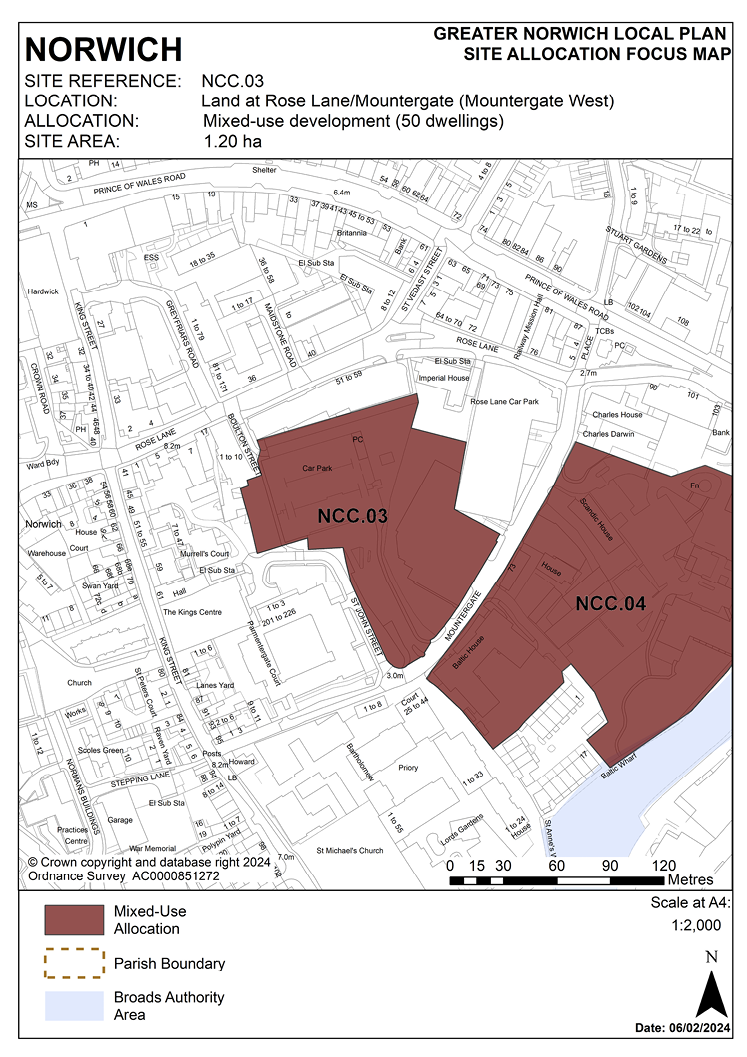
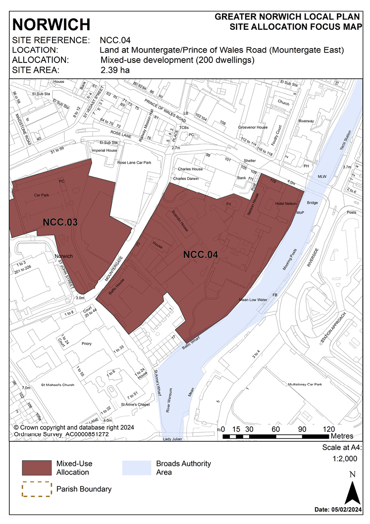
POLICY NCC.03 and NCC.04
Land at Rose Lane/Mountergate, Norwich
3.20 Sites NCC.03 and NCC.04 were identified in the previous local plan as a single allocation CC4. Within the area of the original allocation there has been limited redevelopment and change of use of premises and sites closest to Rose Lane. Completed developments include the refurbishment of the Union Building for managed workspace, conversion of Imperial House to flats, construction of the replacement Rose Lane Car Park and establishment of the Charles Darwin Primary Academy within former office buildings fronting Prince of Wales Road. Due to the completion of these developments, these premises are excluded from the revised allocation. Emerging proposals providing for the potential redevelopment and replacement of the dated Hotel Nelson (Premier Inn) including complementary mixed-use development, strongly favour integration of that site within the allocation to exploit the potential of its river frontage.
3.21 Evidence from the GVA Employment and Town Centres study 2018 points to significant demand for high-quality employment space for developing businesses in the digital creative sector and other sectors supporting the city centre economy, preferably requiring a location close to sustainable transport hubs. Accordingly, scope for a significant element of employment use is identified in site NCC.03 west of Mountergate to take advantage of its location close to Norwich Railway Station. Land east of Mountergate (NCC.04) is promoted for a broader mix of uses with a significant element of residential use, effective integration of the Hotel Nelson site and possible reuse or redevelopment of offices at Baltic House.
3.22 There appears to be a private surface water sewer in the centre of the NCC.03 site. The site is surrounded by a mixture of combined sewer systems and standalone surface water sewer systems. Permission from the owner of the facilities must be gained before use in a proposed drainage strategy. In addition, there is an existing surface water sewer in Anglian Water’s ownership within the boundary of the site. This should be taken into account in the design of the development including safeguarding suitable access for maintenance.
3.23 Sites NCC.03 and NCC.04 are likely to accommodate at least 250 homes with around 50 being accommodated on site NCC.03 and 200 on site NCC.04. Development of site NCC.03 should explore continued use/re-provision of the existing community garden facility. Development of site NCC.04 must be of a scale and form which respects and takes advantage of its riverside context and location in respect of the Broads. As the site lies adjacent to the River Wensum, it is recommended that developers engage in early discussions with the Environment Agency and the Broads Authority. Development of the sites must address a number of constraints including their location within the City Centre Conservation Area and the area of main archaeological interest.
3.24 Norfolk Minerals and Waste Core Strategy policy CS16 applies, as this site is underlain by safeguarded minerals resources. The benefits of extracting the minerals, if feasible, will be taken into consideration.
POLICY NCC.03
Land at Rose Lane/Mountergate (Mountergate West), Norwich (1.20 hectares) is allocated for mixed-use development to include high-quality office space, managed workspace and live-work units, and approximately 50 homes.
The development will achieve the following site-specific requirements:
- Be mainly employment-led, integrated with residential uses.
- Include other uses such as food/drink, and small-scale retail uses.
- Achievement of a high-quality, locally distinctive design of a scale and form which respects its location within the City Centre Conservation Area, conserves and, where opportunities arise, enhances adjoining heritage assets and their settings and contributes to an overall enhancement of townscape quality.
- Respect the setting of adjacent listed buildings and be designed as far as possible to reflect the historic building plots and streets and to recreate street frontages.
- Provides an enhanced public realm, including open space and pedestrian/cycle links through the adjoining site NCC.04 to the riverside walk in accordance with policy 7.1 and the ‘River Wensum Strategy’. Consideration should be given to retaining and enhancing the existing community open space to the rear of Boulton Street as part of integrated open space and green infrastructure network within the site.
- A noise assessment is required, and the development must be designed to mitigate the impact of noise from the main road and from the late night activity zone.
- Ensures a high level of surface water flood resilience and incorporates appropriate flood mitigation measures addressing identified risks from surface water flooding and existing private surface water sewer in the centre of the site, all of which must be taken into consideration when designing a drainage strategy for the site.
- The site is located within the area of main archaeological interest. An archaeological assessment will be required as part of a planning application.
POLICY NCC.04
Land at Mountergate/Prince of Wales Road (Mountergate East), Norwich (2.39 hectares) is allocated for mixed-use development. This may accommodate approximately 200 homes, together with student accommodation, high-quality office space, hotel and tourism uses, and other supporting main town centre uses taking advantage of the site’s proximity to the railway station and river.
The development will achieve the following site-specific requirements:
- Development to be approached comprehensively to achieve effective integration of the historic buildings in the western part of the site into the overall development.
- Other uses may be provided as part of a balanced mix including hotel development (replacing or supplementing the existing hotel provision on- site), student accommodation, educational facilities to support the adjacent Charles Darwin Primary Academy, high-quality office space, managed workspace and live-work units, food/drink, small-scale retail and uses supporting the evening economy.
- Achievement of a high-quality, locally distinctive design of a scale and form which respects its location within the City Centre Conservation Area and adjacent to the St. Matthews Conservation Area, conserves and, where opportunities arise, enhances adjoining heritage assets and their settings and contributes to an overall enhancement of townscape quality. The site’s position relative to Norwich Railway Station warrants building of notable standard of design and quality worthy of marking arrival into the city.
- Respect and enhance the setting of on-site historic buildings including St. Faiths House and the Weavers House and off-site buildings including the railway station, the Anglican Cathedral and Norwich Castle, and be designed as far as possible to reflect historic building plots and street lines and to recreate street frontages.
- Redevelopment, conversion or change of use of Baltic House for uses consistent with this policy will be supported if it becomes available in the plan period.
- A density of development commensurate with its location close to the railway station mobility hub with a design that secures a significant overall reduction in the level of off-site surface car parking.
- Provides an enhanced public realm, including public open space and legible and permeable pedestrian/cycle routes to link through the adjoining site NCC.03 to Rose Lane and the new St. Anne’s Quarter development to King Street. A link should be provided from Mountergate to the river connecting with Prince of Wales Road via an extended and widened riverside walk in accordance with policy 7.1 and the ‘River Wensum Strategy’, making the most of its riverside location.
- Provision of public access and public open space.
- A noise assessment is required, and the development must be designed to mitigate the impact of noise from the main road and from the late-night activity zone.
- High-quality green infrastructure, landscaping, planting, and biodiversity enhancements particularly along the river edge taking advantage of its riverside context and location in respect of the Broads.
- Protection of bankside access for maintenance purposes.
- Ensure a high level of flood resilience and incorporate appropriate mitigation measures (including addressing identified risks from flooding from rivers and surface water flooding).
- The site is located within the area of main archaeological interest. An archaeological assessment will be required as part of a planning application.
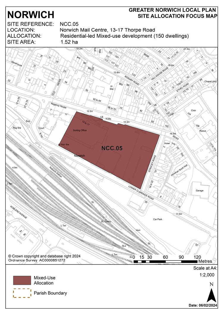
POLICY NCC.05
Norwich Mail Centre, 13-17 Thorpe Road, Norwich
3.25 The site is 1.52 hectares in size and is located in the eastern part of the city centre on the south side of Thorpe Road (A1242), a busy and heavily trafficked radial route serving the east side of the city.
3.26 The site has frontages to Thorpe Road, Lower Clarence Road and Stracey Road. It is currently occupied and operated by Royal Mail Group and accommodates Royal Mail’s Norwich sorting office, ancillary office and storage uses and vehicle parking. The substantial main building dates from the 1950s.
3.27 Thorpe Road is characterised by late Victorian three and four-storey terraces (partly within St Matthews Conservation Area) accommodating a mix of uses including offices, small hotels, guest houses, flats and houses in multiple occupation, interspersed with larger scale office development including a substantial refurbished 1970s office building (Yare House) opposite the site. There are housing developments directly to the west (Great Eastern Court and Regency Court) which incorporate locally listed buildings. The site is immediately adjacent to the St Matthews Conservation Area to the west.
3.28 The site is accessible to a range of city centre facilities including the Riverside retail and leisure complex and has convenient and direct access to the railway station. Vehicular access is taken from Lower Clarence Road which acts as a service road running to the rear of the site: land on the south side of Lower Clarence Road is currently used for long stay public car parking and is also proposed for future development. The Lower Clarence Road frontage overlooks the main platforms and marshalling yards on the approach to the railway station. The site is at present dominated by semi-industrial post-war buildings of little architectural merit with large areas of car and lorry parking which do little to respect the character and context of the area.
3.29 The site was allocated in the previous local plan but has not yet been developed. As evidence has shown it is deliverable, it is re-allocated for residential development in this plan. It is likely to accommodate approximately 150 homes.
POLICY NCC.05
Norwich Mail Centre, 13-17 Thorpe Road, Norwich (1.52 hectares) is allocated for residential-led mixed-use development. This will accommodate approximately 150 homes.
Redevelopment of this site should include:
- Housing (approximately 150 dwellings); housing should predominate with a mix of sizes and types.
- On-site open space and play space; and
- Offices.
The development will achieve the following site-specific requirements:
- Achievement of a high-quality, locally distinctive and energy efficient design of a scale and form which is in keeping with the character of the area, respects the heritage significance of the nearby designated heritage assets (Grade II listed buildings: The Coach and Horses public house, 60 Thorpe Road and Norwich Railway Station), immediately adjacent St Matthews Conservation Area and protects the amenity of adjoining residential occupiers.
- Re-establish built frontages to Thorpe Road, Lower Clarence Road and Stracey Road, with enhanced landscaping and green infrastructure and improved pedestrian and cycle links through the site.
- A noise assessment is required, and the development must be designed to mitigate the impact of noise from the main road and the railway station.
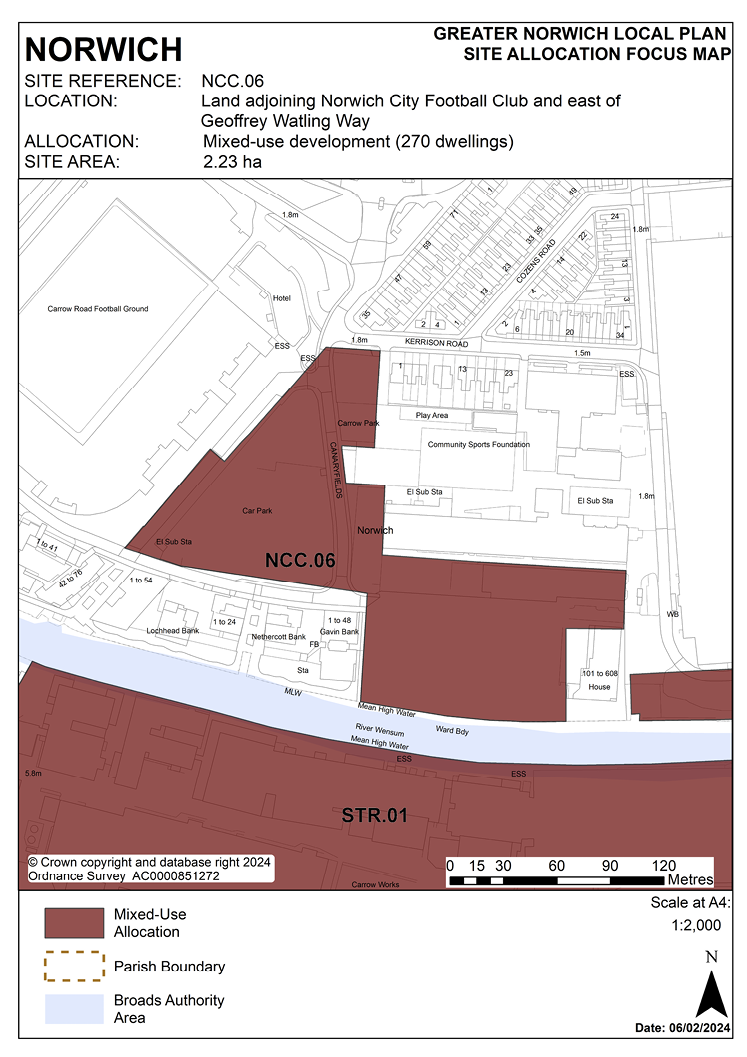
POLICY NCC.06
Land adjoining Norwich City Football Club north and east of Geoffrey Watling Way, Norwich
3.30 The site was allocated in the previous local plan and the western part of the original allocation at Geoffrey Watling Way has been developed. Much of the remaining land on the river frontage (Carrow Quay) has planning permission and development has substantially progressed. Land at the football club car park and groundsman’s hut site remains appropriate for development; the latter site has planning permission for 73 units of housing (Carrow View) and work has commenced on-site. As evidence has shown it is deliverable, it is re-allocated for residential development in this plan.
3.31 The site is located to the east of city centre and is 2.23 hectares in size. It straddles the city centre boundary with most of the western part of the site within the defined city centre area. The majority of the land is currently used as surface car parking.
3.32 Norwich City Football Club’s Carrow Road stadium is immediately to the west of the site, and the southern part of the site is adjacent to the River Wensum, with Carrow Works (part of the East Norwich Strategic Regeneration Area, site STR.01 in this plan) opposite. To the north and east is ATB Laurence Scott’s buildings at both the Gothic Works site and the engine test bed building. Further north is a residential area with mainly two-storey Victorian terraced houses. The main point of access to the site is from the north-west corner at the junction of Carrow Road and Kerrison Road.
3.33 This part of the city has traditionally been a manufacturing area; however it is increasingly being developed for housing and a mix of uses.
3.34 The development of this site for a mix of uses will deliver high density housing and contribute to the regeneration of the wider east Norwich area, making efficient use of its highly accessible location close to public transport routes, the railway station, and the strategic cycle route network. Its current use for surface car parking is an inefficient use of the site.
3.35 Development must address the site’s constraints which include its location adjacent to the River Wensum, flood risk, possible contamination, access capacity. Development of the site must be of a scale and form which respects and takes advantage of its riverside context and location in respect of the Broads.
3.36 The south of the site along the river, and the south-eastern corner is vulnerable to noise from the railway and especially its bridge, access and location of a small part of the site being within Trowse railhead consultation area. Therefore, appropriate mitigation measures are required to mitigate the noise impact on the proposed development.
3.37 The site should be housing-led but could also include other ancillary uses including small-scale office and retail units to serve local needs only; any non-residential uses will be expected to provide minimal and operational parking needs only.
3.38 The future development of this site is critical to unlocking development of the neighbouring Deal Ground, Utilities Site and Carrow Works (the East Norwich Strategic Regeneration Area), which is constrained in terms of access. Development of the East Norwich area requires a comprehensive approach to be taken to access, particularly in terms of public transport links and pedestrian and cycle links.
3.39 Consequently, the development must provide access for public transport and an associated interchange on-site and include a public transport strategy for the wider East Norwich area. This will enable the East Norwich development to link with the railway station / riverside area and the city centre.
3.40 Given the site’s highly accessible location and the intention to provide new public transport links it is considered suitable to include car-free housing. In any event car parking levels should be kept low.
3.41 The development must also provide for access to the river, and provision of riverside walk along its river frontage, as part of the proposed strategic cycle and pedestrian link from the city centre to Whitlingham Broad.
3.42 The development must be designed to minimise the impact of noise generation, light and odour pollution from adjacent industrial uses on new residential occupiers.
3.43 There are several listed factory buildings adjacent to the south of the river. The impact of development on the conservation area and river frontage must be carefully considered. The site is also adjacent to important Palaeolithic deposits which will require archaeological evaluation.
3.44 Consideration should also be given to the safe and successful continued functioning of the football club, creating a high-quality design overall.
3.45 This site lies adjacent to the River Wensum. It is recommended that developers engage in early discussions with the Environment Agency and the Broads Authority.
3.46 Development needs to ensure that the water environment is protected throughout the development of the site. The site falls within source protection zone 1, designated to protect water supplies, and therefore the water environment is particularly vulnerable in this location. Detailed discussions over this issue will be required with the Environment Agency to ensure that proposals are appropriate for the site and that the site is developed in a manner which protects the water environment.
3.47 The site is likely to accommodate approximately 200 homes on the currently undeveloped part of Carrow Quay site and approximately 70 homes on the groundsman’s hut/car park site.
3.48 Norfolk Minerals and Waste Core Strategy policy CS16 and NPPF ‘agent of change’ principles apply as part of this site is within the consultation area of a safeguarded mineral infrastructure (aggregate and roadstone railhead and asphalt plant).
POLICY NCC.06
Land adjoining Norwich City Football Club north and east of Geoffrey Watling Way, Norwich (2.23 hectares) is allocated for mixed-use development to include residential, leisure, community, office and ancillary small retail uses. This will accommodate approximately 270 homes.
The development will achieve the following site-specific requirements:
- Achievement of a high-quality, locally distinctive design of a scale and form which respects its riverside context, ensures a high level of flood resilience and incorporates appropriate mitigation measures (including addressing identified risks from flooding from rivers and surface water flooding).
- Conserve and, where opportunities arise, enhance the setting of the adjacent Bracondale Conservation Area and nearby statutory listed buildings and scheduled monuments (including Carrow Priory and Boom Towers) (including any contribution made to their significance by setting).
- Provide a public transport interchange on-site and a public transport strategy for the wider East Norwich Strategic Regeneration Area.
- Provide public access to the river and a riverside walk/cycle link to facilitate the re-routing of national cycle route 1/red pedalway to Whitlingham and connections to the regeneration opportunity sites to the south and east including the Deal Ground, the Utilities site and Carrow Works in accordance with policy 7.1 and the ‘River Wensum Strategy’.
- Enhance the river frontage as a gateway to Norwich city centre.
- Be designed to mitigate the impact of noise generation, light and odour pollution from adjacent industrial uses and the railway.
- High-quality green infrastructure, landscaping, planting, and biodiversity enhancements particularly along the river edge and forming a setting for the stadium.
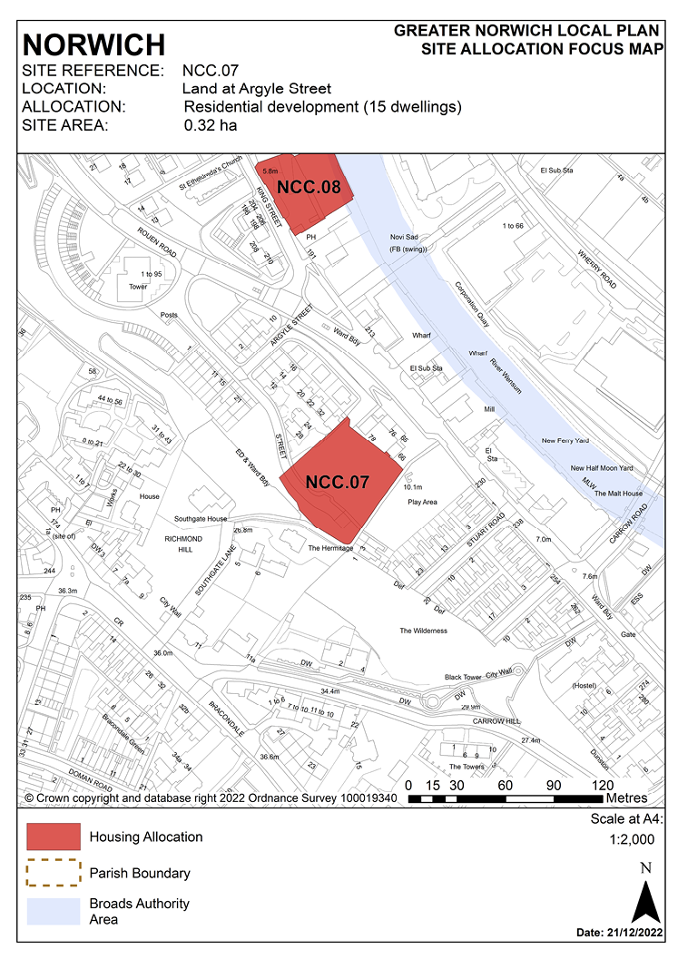
POLICY NCC.07
Land at Argyle Street, Norwich
3.49 The site was allocated in the previous local plan but has not yet been developed. Demolition of subsidence damaged bungalows previously on the site has been taken account of in the calculation of historic housing delivery. As evidence has shown the site is deliverable, it is re-allocated for residential development in this plan.
3.50 The site is in the southern part of the city centre and is 0.32 hectares in size.
3.51 The site is adjacent to a housing area to the north and neighbours the remains of St. Peter Southgate Church (Grade II listed) and its former churchyard, which is a designated public urban green space with play equipment. It is also adjacent to the Ber Street wooded ridge on its south-western boundary.
3.52 Argyle Street is in the Rouen Road/King Street area and is covered by King Street section of the City Centre Conservation Area appraisal. The area is undergoing significant change and many former industrial buildings close to the river have been replaced or converted to residential uses. The wooded ridge which runs from Thorn Lane to Argyle Street forms an important ecological link within the city centre and extends along the south of the site through the historic churchyard.
3.53 The allocation of this site for housing development will bring it back into use and help regenerate this part of the King Street area.
3.54 Development must address the site’s constraints. The site’s history of subsidence means that future development must address the ground condition issue requiring significant ground conditions investigations and any necessary mitigation prior to development.
3.55 Development should have regard to the City Centre Conservation Area appraisal.
3.56 The wooded ridge should be protected and development should seek to enhance the green corridor network which runs adjacent to the site.
3.57 An archaeological investigation will be required.
3.58 Development needs to ensure that the water environment is protected throughout the development of the site. The site falls within source protection zone 1, designated to protect water supplies, and therefore the water environment is particularly vulnerable in this location. Detailed discussions over this issue will be required with the Environment Agency to ensure that proposals are appropriate for the site and that the site is developed in a manner which protects the water environment.
3.59 The site is likely to accommodate approximately 15 homes. This will include affordable housing providing a mix of affordable tenures consistent with identified needs at the time of submission of a planning application and subject to viability, but it is expected that as the land is in public ownership, the site is capable of delivering a scheme of 100% affordable dwellings.
POLICY NCC.07
Land at Argyle Street, Norwich (0.32 hectares) is allocated for residential development. This will accommodate approximately 15 homes.
The development will achieve the following site-specific requirements:
- The design of development must respect the adjacent wooded ridge and seek to enhance the green corridor network which runs adjacent to the site; conserve and, where opportunities arise, enhance the significance of the City Centre Conservation Area and nearby statutory and locally listed buildings, specifically the remains of Grade II listed St. Peter Southgate church, including any contribution made to their significance by setting.
- Potential ground stability issues should be addressed in the design and configuration of new housing, with scope for the use of dwelling types employing lightweight modular construction.
- The site is located within the area of main archaeological interest. An archaeological assessment will be required as part of a planning application.
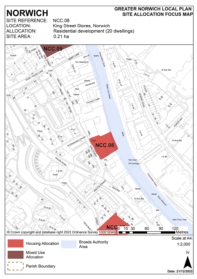
POLICY NCC.08
King Street Stores, Norwich
3.60 The site was allocated in the previous local plan but has not yet been developed. As evidence has shown it is deliverable, it is re-allocated for residential development in this plan.
3.61 The King Street area is mixed in character, with some very important old domestic buildings interspersed with more recent industrial buildings. There are many listed and locally listed buildings along the length of the street. King Street is an area of great change, with many buildings formerly associated with industry or the river being replaced or converted, many of these for residential use.
3.62 King Street has been promoted as a regeneration priority by the council for a number of years. The ongoing regeneration and enhancement of the area, including reinstatement of many building lines and reuse of traditional buildings, will create a more cohesive townscape and a strategically important area linking Riverside with the city centre.
3.63 Trees on the site frontage to site NCC.08 are protected by a tree preservation order. Redevelopment of the site should seek to retain them for their individual value and for the contribution that they make to the streetscape. Any loss or partial loss will require clear and convincing justification.
3.64 Redevelopment of the site must address a number of constraints including its location within the City Centre Conservation Area and the area of main archaeological interest. Its redevelopment provides an opportunity to sensitively regenerate this part of King Street by contributing positively to the character of the street. In accordance with the conservation area appraisal, the scale of development should reflect the existing traditional buildings, and public realm works should help create a high-quality and unified streetscape.
3.65 Any demolition would require planning permission. Development proposals should be informed by a heritage assessment of the locally listed building to assess its significance. It should be retained as part of the development scheme if appropriate.
3.66 A flood risk assessment and appropriate flood risk mitigation measures are required. Given its proximity to the King Street frontage, the site will require an archaeological evaluation through trial trenching prior to its development.
3.67 The site is suitable for high density development given its location; approximately 20 dwellings are expected.
3.68 The site lies adjacent to the River Wensum. A written consent from the Environment Agency is required for proposed works or structures, in, under, over or within 9 metres of the top of the bank of a designated ‘main river’. It is recommended that developers engage in early discussions with the Environment Agency. Development of the site must be of a scale and form which respects and takes advantage of its riverside context and location in respect of the Broads. Development needs to ensure that the water environment is protected. As the site lies adjacent to the River Wensum, it is recommended that developers engage in early discussions with the Environment Agency and the Broads Authority
3.69 The site falls within source protection zone 1, designated to protect water supplies, and therefore the water environment is particularly vulnerable in this location. Detailed discussions over this issue will be required with the Environment Agency to ensure that proposals are appropriate for the site and that the site is developed in a manner which protects the water environment.
3.70 The site is served by an off-site combined foul and surface water sewer. Adoption of this facility into a proposed drainage strategy must be pre-agreed with the appropriate management company.
POLICY NCC.08
King Street Stores, Norwich (0.21 hectares) is allocated for residential use. This will accommodate approximately 20 homes.
The development will achieve the following site-specific requirements:
- Development proposals will contribute to the regeneration of the King Street area.
- Achievement of a high-quality, locally distinctive design of a scale and form which conserves and, where opportunities arise, enhances its location within the City Centre Conservation Area and nearby listed buildings (including adjacent Grade II listed Ferryboat Inn former public house) including any contribution made to their significance by setting.
- Seek to retain the TPO trees at the street frontage to the site enabling continued healthy growth. Any loss or partial loss will require clear and convincing justification.
- Seek to retain and enhance the locally listed structure on-site through adaptive reuse. Any loss or partial loss will require clear and convincing justification.
- Explore opportunities to provide a link through the site to the Novi Sad bridge to the south through the adjacent Ferryboat redevelopment site, and potential for a future riverside walkway to the north. In the event of a scheme creating the opportunity for access to the river, the amenity value of this should be optimised for the benefit of the development, respecting and taking advantage of its riverside context and location in respect of the Broads.
- Protection of bankside access for maintenance purposes.
POLICY NCC.09
Hobrough Lane, King Street, Norwich
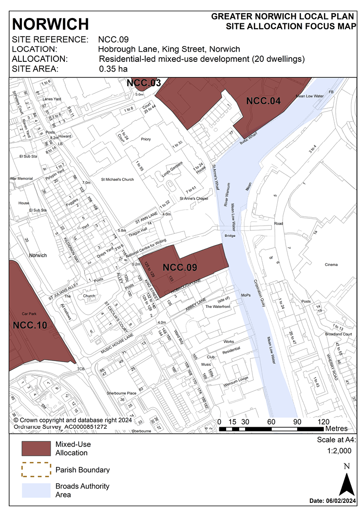
3.71 The site was allocated in the previous local plan and was subject to two previous approved schemes on adjoining parts of the site which together would have delivered a total of 20 homes. These permissions have expired, and the site has not yet been developed. As evidence has shown the site is deliverable, it is allocated for residential-led mixed-use development in this plan.
3.72 The site fronts King Street adjacent to Hobrough Lane and extends down to the River Wensum. It is 0.35 hectares in size. It is adjacent to the listed local landmark of Dragon Hall and is close to a strategic pedestrian and cycle link and Lady Julian Bridge, linking the leisure and retail area of Riverside with the primary retail area at Castle Quarter.
3.73 The frontage of the site consists of two disused Grade II* listed buildings ‘at risk’ (125-127 King Street). These are early 16th century first floor buildings, with a poor quality 20th century arcaded ground floor conversion and rear industrial extensions, surface parking and delivery areas, and are currently unoccupied. These buildings must be brought back into residential use and renovated to ensure their future and to remove them from the register.
3.74 The wider King Street area has many historically significant buildings interspersed with former industrial buildings. The area is undergoing significant change as many of the buildings formerly associated with industry and the river are either being replaced or converted, mostly into residential use. The northern part of King Street retains a greater number of traditional buildings and forms a more coherent townscape.
3.75 Redevelopment of the site offers the opportunity to make better use of this valuable city centre site and to continue the development of a vibrant mixed-use quarter in King Street, extending housing, leisure office and small-scale retailing uses along King Street.
3.76 Development proposals should take account of the City Centre Conservation Area appraisal. The layout and design of the development should ensure the reuse and enhancement of the listed buildings fronting King Street to reveal their significance, and seek to enhance the setting of the adjacent Dragon Hall. The development should also take account of the adjacent St. Anne’s Wharf redevelopment and provide a publicly accessible riverside walk linking to the core pedestrian and cycle network at Lady Julian Bridge.
3.77 Development should help to regenerate the King Street area by reinstating the historic street frontage of King Street (the ground floor of 125-127 King Street and the missing frontage at 131-133 King Street).
3.78 In this highly accessible city centre location, car-free housing is appropriate in accordance with policy 2. If this approach is not taken, vehicular access should be via the south of the site/Hobrough Lane.
3.79 Appropriate historic interpretation information should be incorporated into the development and an archaeological assessment will be required.
3.80 Although there are no tree preservation orders on the site, an assessment will have to be undertaken of the value of trees on the river frontage, and appropriate mitigation measures included in any planning application.
3.81 Development should also take into account possible site contamination.
3.82 As part of the site is within flood zone 2, it could be affected by fluvial flooding. In addition, as it is located between the Ber Street ridge and the River Wensum, it could be affected by surface water flooding. Therefore a flood risk assessment and appropriate mitigation measures will be required.
3.83 The site lies adjacent to the River Wensum. It is recommended that developers engage in early discussions with the Environment Agency and the Broads Authority.
3.84 Development needs to ensure that the water environment is protected. The site falls within source protection zone 1, designated to protect water supplies, and therefore the water environment is particularly vulnerable in this location. Detailed discussions over this issue will be required with the Environment Agency to ensure that proposals are appropriate for the site and that the site is developed in a manner which protects the water environment. Development of the site must be of a scale and form which respects and takes advantage of its riverside context and location in respect of the Broads.
3.85 The site is likely to accommodate approximately 20 homes.
POLICY NCC.09
Hobrough Lane, King Street, Norwich (0.35 hectares) is allocated for residential-led mixed-use development. This will accommodate approximately 20 homes.
The development will achieve the following site-specific requirements:
- Residential development with small-scale retail and/or offices, food and drink, and tourist uses.
- Secure sensitive conversion of historic buildings fronting King Street including removal of the unsympathetic post-war alterations.
- New development should respect the historic integrity and setting of 125-129 King Street and conserve and, where opportunities arise, enhance heritage assets and their settings in this part of the City Centre Conservation Area.
- Enhance the public realm along King Street and Hobrough Lane and provide a riverside walk linking to the cycle/pedestrian route to Lady Julian Bridge.
- Be of a scale and form which respects and takes advantage of its riverside location, providing high-quality landscaping, planting, and biodiversity enhancements particularly along the river edge.
- Heritage interpretation will be provided as part of the scheme.
- 125-127 and 129 King Street is on Norwich’s register of local heritage buildings at risk. Any development of this site must include renovation to ensure their future and remove them from the register in agreement with Norwich City Council.
- Provide protection of bankside access for maintenance purposes.
- The site is located within the area of main archaeological interest. An archaeological assessment will be required as part of a planning application.
POLICY NCC.10
Land at Garden Street and Rouen Road, Norwich
3.86 The site was allocated in the previous local plan for housing but has not yet been developed. A previous option to provide a primary school on the site has not been progressed due to additional school capacity since becoming available in the city centre. As evidence has shown the site is deliverable with development expected to take place within 10-15 years, the site is re-allocated for mixed-use development.
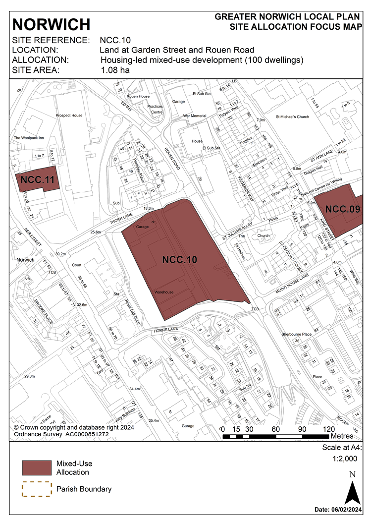
3.87 The site includes land on both sides of Garden Street and is 1.08 hectares in size. The site contains a surface car park and light industrial buildings, mainly used for motor related businesses. The City Centre Conservation Area appraisal identifies the buildings on the site as ‘negative buildings’, detracting from the character of the conservation area.
3.88 The site is surrounded by a mix of uses, predominantly residential flats and some office and light industrial buildings. The site is partially surrounded to the west and south by the Ber Street wooded ridge which is an ecological link and a publicly accessible open space.
3.89 This part of the city centre is a very mixed area with a combination of industrial and residential uses. There is a large housing area set back from the main streets, mostly in cul-de-sacs off Rouen Road. The houses are in blocks, often surrounded by empty green spaces and parking areas or garage blocks. This layout provides very little visual enclosure to the street, with few buildings directly fronting onto it. The repetitive design together with the lack of detailing of much of this housing forms a contrast with the remaining traditional properties. A large section of the west side of Rouen Road is surface car parking, again providing no enclosure. Normandie Tower, a large residential tower block, is to the south of the site.
3.90 Development will present an opportunity to improve the townscape of Rouen Road and enhance green infrastructure.
3.91 Development must address the site’s main constraints which include its location in the City Centre Conservation Area and Area of main archaeological interest, possible contamination, its topography with land sloping down to the south-east of the site and its location adjacent to the Ber Street wooded ridge. Ground conditions are a potential constraint as this is the site of former chalk workings. Long leases on some of the existing light industrial units may also be a constraint.
3.92 Relatively high density development is possible on this highly accessible city centre site.
3.93 The large surface car park, although presenting a negative view along Rouen Road, serves an important function in this part of the city centre and public parking should be incorporated into redevelopment, possibly by incorporating it into the lower levels with a visual curtain of active frontage to the street. Redevelopment should also cater for the needs of small businesses in the city centre area by providing small business units as part of the comprehensive development.
3.94 The design principles of the development should establish street frontages onto Rouen Road and Thorn Lane. It should also enhance the adjacent Ber Street wooded ridge, and provide for enhanced green infrastructure and landscaping within the site and links to the proposed Norwich Cycle Network which runs along this section of Rouen Road. Vehicular access should be taken from Garden Street, not onto Thorn Lane.
3.95 Given its location, an archaeological investigation will be required prior to development of the site.
3.96 Development needs to ensure that the water environment is protected throughout the development of the site. The site falls within source protection zone 1, designated to protect water supplies, and therefore the water environment is particularly vulnerable in this location. Detailed discussions over this issue will be required with the Environment Agency to ensure that proposals are appropriate for the site and that the site is developed in a manner which protects the water environment.
3.97 The site is likely to accommodate approximately 100 homes.
POLICY NCC.10
Land at Garden Street and Rouen Road, Norwich (1.08 hectares) is allocated for housing led mixed-use development. This will accommodate approximately 100 homes. This site could include an element of small-scale office/business units to cater for small business.
The development will achieve the following site-specific requirements:
- Achievement of a high-quality, locally distinctive design of a scale and form which conserves and, where opportunities arise, enhances its location within the City Centre Conservation Area and nearby listed buildings, including any contribution made to their significance by setting.
- Any development must be designed to protect neighbour amenity, protect, and enhance the wooded ridge to the east and south of the site, and to provide enhanced landscaping, green infrastructure, and improved pedestrian and cycle links through the site.
- Given its location, an archaeological investigation will be required prior to development of the site.
- Vehicular access for residential development should be via Garden Street and not off Rouen Road.
- Equivalent replacement public parking spaces will be provided as part of the scheme, accessed from Rouen Road.
POLICY NCC.11
10 – 14 Ber Street, Norwich
3.98 The site was allocated in the previous local plan but has not yet been developed. As evidence has shown it is deliverable, it is re-allocated for residential development in this plan.
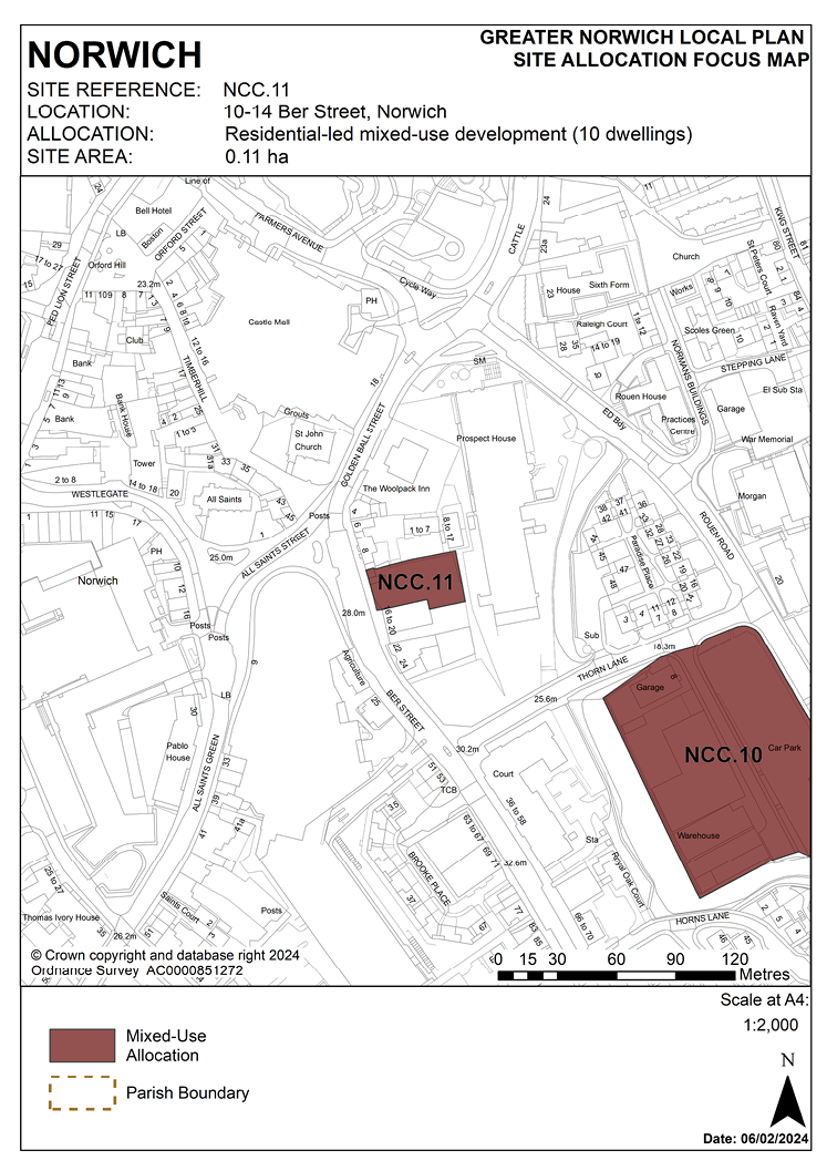
3.99 The site is 0.1 hectares in size and is located on the eastern side of Ber Street close to the junction with All Saints Green and Golden Ball Street. It comprises a vacant building at number 10 with the site of 12-14 adjacent, previously used as open storage land.
3.100 This site is on the fringe of the primary shopping area. It has an open, incoherent street frontage with a mix of building sizes and character. Number 10 is dated and of poor quality. The City Centre Conservation Area appraisal identifies the buildings on the site as ‘negative buildings’, detracting from the character of the conservation area. There are a number of listed and locally listed buildings directly opposite the site on the west side of Ber Street.
3.101 Ber Street has been a major route out of the city since at least the 12th century and is thought to have originally been a Roman road. Its use as a cattle drove to the old cattle market adjacent to the Castle is reflected in its unusual width. Today, following bomb damage during the Second World War and subsequent redevelopment, the street is fragmented in character, with remnants of its earlier character apparent but with much mid-20th century housing. The wider area is predominantly residential with some office development, and other commercial uses along Ber Street.
3.102 Development of the site must address a number of constraints including its location within the City Centre Conservation Area and the area of main archaeological interest, its location adjacent to listed buildings and possible contamination. The development of the site provides an opportunity to deliver a vibrant mixed-use site fronting Ber Street, which will contribute positively to the character of the street and will remove ‘negative’ buildings which currently detract from its streetscape and character.
3.103 The site is suitable for approximately 10 dwellings as part of a mixed-use development, with some retail and/or office development along the Ber Street frontage. Development must enhance the setting of the neighbouring listed buildings and reflect its location in the City Centre Conservation Area. Its design must re-instate a strong building line along the street frontage, whilst respecting the area’s important topography and neighbouring uses.
3.104 The site is suitable for car-free housing given its sustainable location and the provision of a car club space on Ber Street would be welcomed. An access across the site to the development to the rear of 6-8 Ber Street is required and any entrance point onto Ber Street should be located towards the southern boundary of the site.
3.105 An archaeological investigation will be required prior to development.
3.106 The site is served by an off-site combined foul and surface water sewer to its north-west. Adoption of this facility into a proposed drainage strategy must be pre-agreed with the appropriate management company.
POLICY NCC.11
10 – 14 Ber Street, Norwich (0.11 hectares) is allocated for residential-led mixed-use development. This will accommodate approximately 10 homes.
The development will achieve the following site-specific requirements:
- Achievement of a high-quality, locally distinctive design of a scale and form which respects its context including the topography of the area.
- Strengthen the building line along Ber Street and the scale of any new development should reflect that of the neighbouring properties.
- Conserve and, where opportunities arise, enhance the significance of the City Centre Conservation Area and nearby locally and statutory listed buildings (including any contribution made to their significance by setting).
- Retail or complementary uses in use class E (b,c,g(i)) at ground floor level.
- Residential uses (minimum of 10 homes) on the upper floors.
- Reduced levels of residential car parking to achieve low car or car-free housing development, in accordance with policy 2 – Sustainable Communities is appropriate to be provided in this location.
- An archaeological investigation will be required prior to development.
POLICY NCC.12
Land adjoining Sentinel House (St Catherine’s Yard), Surrey Street, Norwich
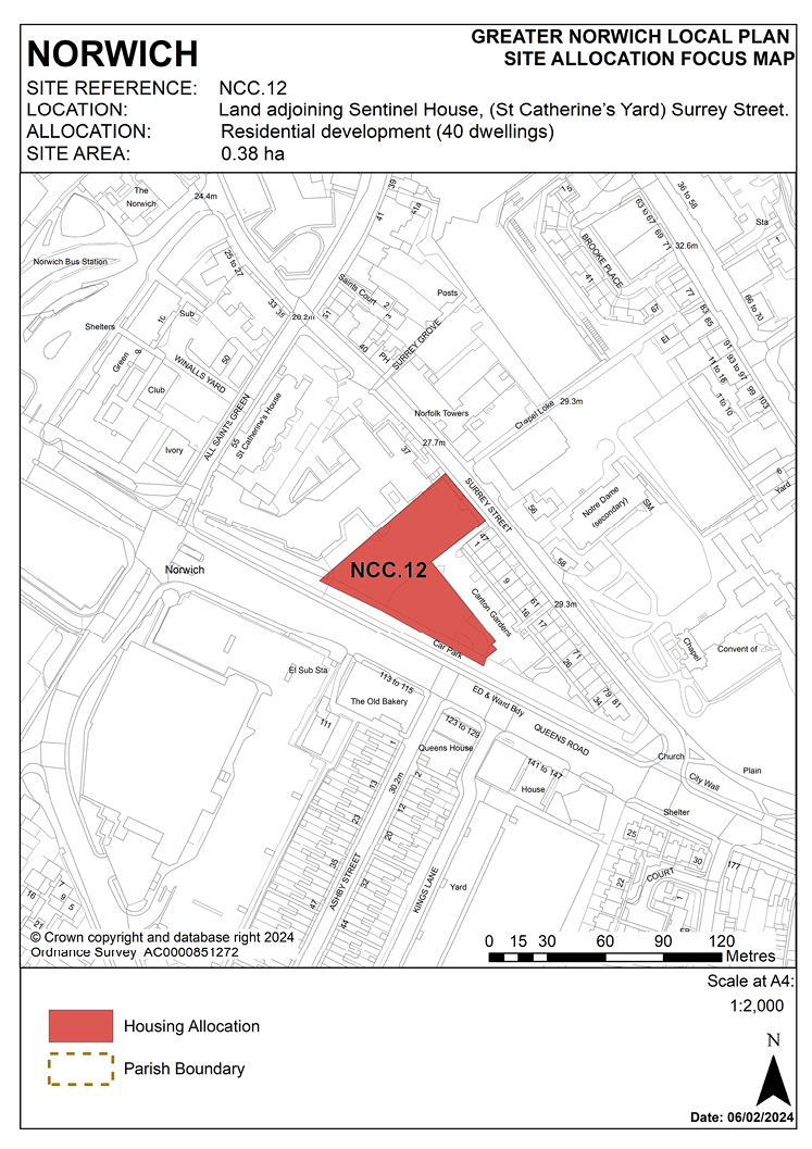
3.107 The site borders Queens Road which forms part of the city’s inner ring road. The site was a former car park for Sentinel House, the current condition of the site is poor. Development has the potential to significantly enhance the quality of the conservation area and the street scene both along Queens Road and Surrey Street. On the Surrey Street side, the site is adjacent to a row of 19th century paired residential terraces known as Carlton Terrace which presents a strong building line and positive frontage. These buildings are locally listed. An office block, Sentinel House, recently converted to residential use lies to the north of the site. Office uses extend further to the north of Surrey Street.
3.108 Surrey Street is a mixed-use quarter of All Saints Green and St Stephens Area. The area is largely dominated by office use though it also contains a major school and some residential properties together with a single public house. This area is characterised by groups of good 18th and 19th century houses, together with the Edwardian headquarters of Aviva. However, their settings are largely dominated by late 20th century office developments of considerable scale. Consequently the townscape is rather fragmented due to the juxtaposition of buildings of varying scale, over-assertive newer buildings on odd building lines and areas of open land and surface car parking.
3.109 The site was previously allocated for mixed-use development of offices and housing alongside the adjacent council-owned Queens Road car park. The majority of the existing car park is not proposed for reallocation in this plan. Around the same number of homes (or equivalent student bedrooms) may be deliverable from this smaller site without the car park being included, albeit that the development capacity of the allocation will be limited by the proximity of adjoining housing and the need to conserve and enhance heritage assets.
3.110 Development of the site must address a number of constraints including its location in the City Centre Conservation Area and Area of main archaeological interest, its location adjacent to the line of the city wall, topography, the relationship with neighbouring locally listed buildings and nearby Grade II listed buildings and noise generation from Queen’s Road. Development must address the amenity of existing neighbouring properties at both Carlton Terrace and Sentinel House, especially in terms of loss of light, overshadowing and privacy.
3.111 The site is expected to accommodate approximately 40 homes or alternatively approximately 200 student bedrooms. The site benefits from extant permission for development of 252-bedroom purpose-built student accommodation.
POLICY NCC.12
Land adjoining Sentinel House, St. Catherine’s Yard, Surrey Street, Norwich (0.38 hectares) is allocated for residential development. This will provide approximately 40 homes, (or, if developed for student accommodation, approximately 200 student bedrooms). Commercial uses including small-scale retail, financial and professional services, restaurants/cafes or other main town centre uses will be accepted at ground floor level where compatible with adjoining residential uses.
The development will achieve the following site-specific requirements:
- Achievement of a high-quality, locally distinctive design of a scale and form which respects its location within the City Centre Conservation Area, conserves and, where opportunities arise, enhances adjoining heritage assets, including a number of Grade II listed buildings, and their settings through careful design, massing and appropriate open space and landscaping; and protects amenity and outlook for existing and future residents.
- If developed as purpose-built student accommodation, Affordable Housing contributions to be provided in accordance with the requirements set out in policy 5 – Homes.
- Reduced levels of residential car parking to achieve low car or car-free housing development in accordance with 2 – Sustainable Communities is appropriate to be provided in this location.
- Provision of a safe and legible pedestrian route through the site to link Surrey Street to Queens Road and enable connections along Queens Road to the junction with All Saints Green and north to Ber Street via Chapel Loke. Vehicular access to the site should be taken from Surrey Street.
- High-quality landscaping, planting, and biodiversity enhancements, open space including retention of trees along the frontage to Queens Road. Replacement planting of new trees will be required to mitigate any loss of poor-quality trees.
- The site is located within the area of main archaeological interest. An archaeological assessment will be required as part of a planning application.

POLICY NCC.13
Land to rear of City Hall, Norwich
3.112 The site was allocated in the previous local plan but has not yet been developed. As evidence has shown it is deliverable, the site is re-allocated for mixed-use development.
3.113 The site is located to the rear of City Hall and is 0.4 hectares in size. The site was previously used as a surface car park and is currently used by Norfolk Constabulary for parking and other police activities.
3.114 This open site is dominated by large-scale civic buildings. There is some relatively recent housing to the west, whilst St. Giles Street to the north retains its mixed historic character. There are green areas and mature trees on the site’s northern boundary. The site is in the City Centre Conservation Area and the area of main archaeological interest and is surrounded by listed buildings.
3.115 The immediate surroundings of the site contain main public buildings forming the civic heart of Norwich. These include the Police Station and former Fire Station, the refurbished market place, and the Forum building. There is easy pedestrian access to the site.
3.116 City Hall has a positive frontage which not only fronts onto St. Peters Street but also wraps around onto Bethel Street and St. Giles Street.
3.117 Land to the rear of City Hall currently contributes very little to the conservation area and the redevelopment of the site has the opportunity to improve the streetscape.
3.118 The original intended plan for City Hall was for there to be a wing on St. Giles Street and there is a strong argument for building this wing to create a street frontage to St. Giles, a courtyard behind the building and a symmetrical arrangement that focuses on the projecting element of City Hall that contains the Council Chamber and is adorned by the three Alfred Hardiman sculptures.
3.119 The redevelopment of land to the rear of City Hall offers the potential to create an attractive new courtyard. This space should be open to the public and new routes should be created through the space to enhance permeability. For example, a new route could be created from St. Giles Street at the junction with the existing part of City Hall diagonally through the courtyard to Bethel Street opposite William Kemp Way which will help improve pedestrian links. If the police compound needs to be retained, then this could be achieved through the provision of a decked landscaped area above.
3.120 Development should address a number of constraints, including the site’s location within the City Centre Conservation Area and the area of main archaeological interest, potential contamination, trees on the northern part of the site, topography, access, the setting of listed buildings, and its relationship with neighbouring housing development. Any development must be clearly based on a heritage assessment informed by the 2005 Conservation Management Plan for the building.
3.121 Any loss of green space on St. Giles Street would have to be mitigated and there would be a need for replacement planting for the loss of any trees.
3.122 Development may require the demolition of existing on-site structures. Its design must respect and enhance the adjacent City Hall and Police Station building which is Grade II* listed. There are significant opportunities to enhance views into and across the site.
3.123 The site is adjacent to the core pedestrian network, therefore development should seek to enhance the existing north-south pedestrian link between St Giles Street and Bethel Street. The site is suitable for car-free development.
3.124 The site is currently below surrounding ground levels. Given the significant change in topography across the site, it may be necessary to raise the ‘active’ parts of the development to above existing ground levels. This could present an opportunity to provide basement car parking or residential / commercial storage, subject to careful designs for access provision.
3.125 The site may accommodate approximately 20 homes if developed for a mix of uses including residential.
POLICY NCC.13
Land to rear of City Hall, Norwich (0.40 hectares) is allocated for mixed-use development which may include residential, offices and managed workspace, food and drink and small-scale retail uses. The alternative option of a hotel development is supported and, if this option is progressed, scope for accommodating residential uses on part of the site should be investigated to retain its potential for housing delivery. If developed with an element of residential uses, the site could accommodate approximately 20 homes.
The development will achieve the following site-specific requirements:
- Achievement of a high-quality, locally distinctive and flood resilient design of a scale and form which has regard to its prominent location within the City Centre Conservation Area, the significance of adjoining heritage assets and their settings, and its position forming part of the setting of the immediately adjoining Grade II star listed City Hall.
- Take account of and respect the original design concept of City Hall and its intended architectural context within a wider planned civic centre. Development must be of an appropriate scale and massing and must be subservient to the main body and façade of City Hall. Therefore, it is important that any new building does not exceed the height of City Hall (including any parapet concealing rooftop plant).
- If redevelopment involves the loss of trees on the St. Giles Street frontage, the development should provide high-quality green infrastructure, landscaping, planting, and biodiversity enhancements.
- Any development must be clearly based on a heritage assessment informed by the 2005 Conservation Management Plan for the building.
- Any loss of green space on St. Giles Street would have to be mitigated and there would be a need for replacement planting for the loss of any trees.
- The scheme should deliver improved connectivity between the Forum and Norwich Lanes by improving and enhancing the north-south pedestrian route between St. Giles Street and Bethel Street.
- The site is located within the area of main archaeological interest. An archaeological assessment will be required as part of a planning application.
POLICY NCC.14
The Former Eastern Electricity Headquarters, Duke’s Wharf, Duke Street, Norwich
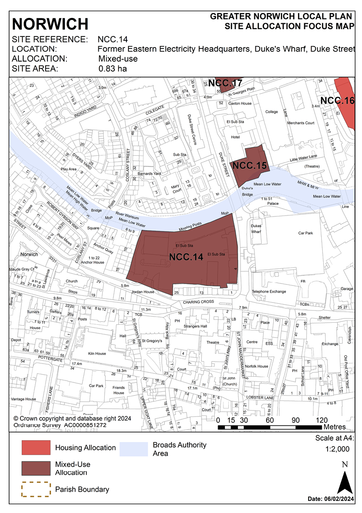
3.126 The former Eastern Electricity Board site is located on the south bank of River Wensum and is 0.83 hectares in size. The site contains the vacant electricity board buildings along the river and the former Boardman buildings fronting Duke Street. The site has two main vehicular access points, from Duke Street and Westwick Street. The site frontage on Duke Street and adjacent to the river is identified as ’positive’ in the City Centre Conservation Area appraisal.
3.127 The site borders existing residential development on the west side. Duke Street is part of the city’s one way system. Adjacent to and south of the site are 1-25 Charing Cross which is dominated by professional services. In the middle of the site is a large open space which was previously used as a temporary car park.
3.128 The riverside area has been the focus of activity for most of Norwich’s history and contains remnants of its former importance. Today, the focus of this activity has shifted from industrial concerns to leisure pursuits and the area is rapidly becoming a popular residential location with many developments recently completed, currently underway, or in the pipeline.
3.129 Development of the site must take account of its constraints which include its location adjacent to the River Wensum and in flood zones 2 and 3, its location in the City Centre Conservation Area and the area of main archaeological interest and adjacent to the Broads, possible contamination, access, site levels and the scale of adjoining development and buildings. Development must maintain and/or recreate strong built frontages to Westwick Street, Duke Street and the River Wensum. Development must be of a scale and form which respects and takes advantage of its riverside context. There is an existing water main in Anglian Water’s ownership within the boundary of the site. This should be taken into account in the design of the development including safeguarding suitable access for maintenance As the site lies adjacent to the River Wensum, it is recommended that developers engage in early discussions with the Environment Agency and the Broads Authority.
3.130 The site is likely to accommodate at least 100 homes, but if developed for student accommodation the number of units could be increased. In either case, the proposals would need to accord with an acceptable design and layout.
3.131 Consent for 69 flats to be delivered through conversion of existing buildings under previous approved proposals has now expired.
3.132 The site lies in flood zone 2, but once climate change is added to the flood levels, the majority of the site lies in flood zone 3a High Probability. If possible, the development should be sequentially sited on land to the south in flood zone 1.
3.133 If development is required to be sited within these future flood zone 3 (1% climate change) outlines, then the more vulnerable residential development will need to be designed with floor levels raised 0.3m above the flood levels for the future 1% (1 in 100) annual probability flood event with 35% and ideally 65% allowances for climate change. Refuge will also need to be provided above the 0.1% (1 in 1,000) annual probability 25% climate change flood levels. Compensatory flood storage will also need to be provided for any new built development or land raising within the 1% (1 in 100) annual probability flood outline with 35% climate change to ensure no increase in flood risk elsewhere. This will require lowering of higher land in flood zone 1 to the south to provide the compensatory flood storage.
POLICY NCC.14
The Former Eastern Electricity Headquarters, Duke’s Wharf, Duke Street, Norwich (0.83 hectares) is allocated for mixed-use development which may include a minimum of 100 homes, (or, if the residential element is provided as student accommodation, at least 250 bedrooms). Employment, managed workspace, leisure, financial and professional services, education, and cultural uses will also be acceptable as part of a balanced mix.
The development will achieve the following site-specific requirements:
- Achievement of a high-quality, locally distinctive design of a scale and form which respects and takes advantage of its riverside context and prominent location within the City Centre Conservation Area and the Broads, maintains and/or recreates strong built frontages to Westwick Street, Duke Street and the River Wensum.
- Conserve and, where opportunities arise, enhance the significance of heritage assets (including any contribution made to their significance by setting) including the City Centre Conservation Area, Grade I listed St. Gregory’s Church and Strangers Hall Museum, Grade II* listed Charing Cross and other buildings listed at Grade II.
- Ensures a high level of flood resilience and incorporates appropriate flood mitigation measures (including addressing identified risks from flooding from rivers and surface water flooding).
- Decommissioning and removal of the existing surface car parking.
- Development may include either the conversion of existing buildings or redevelopment.
- Provision of pedestrian links from Westwick Street to Duke Street and Dukes Palace Bridge, improved permeability of the site making the most of its riverside location.
- Reduced levels of residential car parking to achieve low car or car-free housing in accordance with 2 Sustainable Communities is appropriate to be provided in this location.
- A noise impact assessment and air quality assessment will be required, and the development must be designed to mitigate the impact of noise from the main road.
- High-quality landscaping, planting, and biodiversity enhancements.
- Heritage interpretation measures to be incorporated in accordance with 3 of this plan.
POLICY NCC.15
Land adjacent to the River Wensum and the Premier Inn, Duke Street, Norwich
3.134 This 0.12 hectare site is currently occupied by a surface car park accessed from Duke Street. It is bordered by Duke Street to the west, by a hotel to the north, by a school to the east and by the River Wensum to the south. Development offers opportunity for landscape improvements and provision of a new section of riverside walk on the north bank of the River Wensum.
3.135 Development of the site must address a number of constraints including its location within the City Centre Conservation Area, the area of main archaeological interest and proximity to heritage assets, the Broads, site ground conditions, a critical drainage catchment area and its riverside location including flood zones 2 and 3.
3.136 A noise impact assessment and air quality assessment will be required, and the development must be designed to mitigate the impact of noise from the main road. A previous site investigation report has indicated that there are elevated levels of contamination present on-site, land contamination desk top study and intrusive investigations will be required.
3.137 Early engagement with statutory consultees is always recommended, in this case the Environment Agency and Anglian Water to address flood and water disposal issues. As the site lies adjacent to the River Wensum, it is recommended that developers engage in early discussions with the Broads Authority.3.138 Although not previously allocated in the local plan, the site benefits from an extant 2004 permission for 21 homes. That permission has been implemented and remains valid through the construction of the hotel forming part of the same approved proposals. Further to this, consent was granted in November 2019 for the construction of a 139-bed purpose-built student accommodation block (18/01552/F) which has also been implemented and remains extant. The site is likely to accommodate approximately 25 homes or 125 student bedrooms.
POLICY NCC.15
Land adjacent to the River Wensum and the Premier Inn, Duke Street, Norwich (0.12 hectares) is allocated for residential-led mixed-use development. This will include approximately 25 homes (or if developed for student accommodation, approximately 125 student bedrooms). A small element of commercial, office, and/or educational use at ground floor level may also be acceptable.
The development will achieve the following site-specific requirements:
- Achievement of a high-quality, locally distinctive design.
- A scale and form which respects and takes advantage of its riverside context.
- The need to conserve and, where opportunities arise, enhance the significance of the City Centre Conservation Area and nearby listed buildings (including any contribution made to their significance by setting).
- Ensures a high level of flood resilience and incorporates appropriate mitigation measures, including addressing identified risks from flooding from rivers and surface water flooding.
- If developed as purpose-built student accommodation, affordable housing contributions to be provided in accordance with the requirements set out in 5 – Homes.
- Reduced levels of residential car parking to achieve low car or car-free housing development in accordance with policy 2 – Sustainable Communities is appropriate to be provided in this location.
- Provision of public access to and along the river for walking and cycling, including a ramp from Duke Street, designed to facilitate a future extension of the riverside walk eastward to St.. Georges Street in accordance with policy 7.1 and the ‘River Wensum Strategy’.
- High-quality landscaping, planting, and biodiversity enhancements particularly along the river edge.
- Protection of bankside access for maintenance purposes.
- Existing surface water discharge point located within the boundary of the site which must be addressed as part of any scheme put forward.
- The site is located within the area of main archaeological interest. An archaeological assessment will be required as part of a planning application.
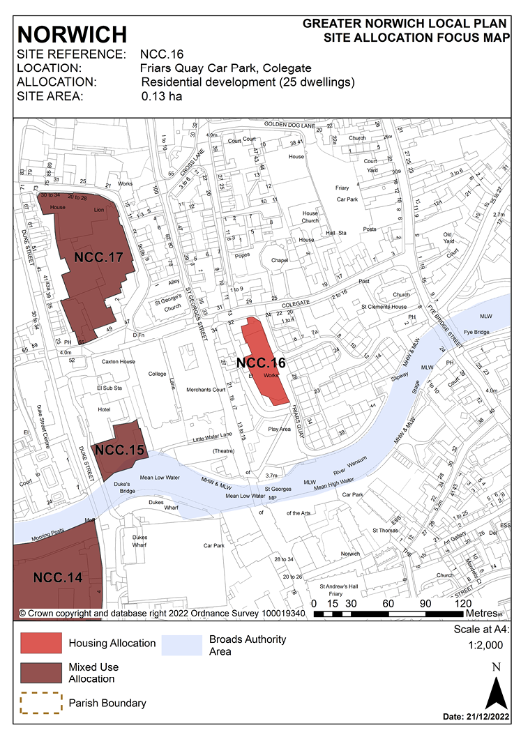
POLICY NCC.16
Friars Quay Car Park, Colegate, Norwich
3.139 This site lies within the Norwich City Centre Conservation Area in the setting of several listed buildings. It forms part of the south side of Colegate, the principle historic street of what was once the Norvic settlement and which contains numerous important historic buildings including several listed ones. A group of Grade II listed buildings are situated on Colegate at the north end of the site as well as the parish church of St. George (Grade I listed) and the Grade II* listed Bacon’s House and numbers 2-9 Octagon Court. The site also lies in an interesting position in the conservation area where the nature of historic building changes. Modern development between Colegate and the river (Friar’s Quay) is akin in scale and form to the generally low-rise, domestic scale of development on the north side of the river stretching along Colegate eastwards to Magdalen Street. The Friar’s Quay development is a very successful and early example of modern residential development in an historic city which responds to the historic ‘grain’ of development from a time when development commonly disregarded it. To the west side of the application site is St. George’s Street, also characterised by relatively modest, pitched roofed development, both historic (including the Grade II listed numbers 22-25) and later infill matching it. This street marks the point at which the character of historic development changes. The western side of St. George’s Street features a former 19th century factory building filling a corner plot on Colegate. This is similar in form, though smaller than the 19th century Art College building across the river to the south. Upstream from the college is modern development of a similar scale. St George’s Street can therefore be seen as a ‘hinge’ point in this part of the conservation area and the allocation site being to the east of it falls within the area characterised by more domestic scale development, both old and new.
3.140 Any development of the site therefore has the potential to impact upon a number of heritage assets and their settings.
3.141 Development of the site must address a number of constraints including its location within the City Centre Conservation Area and the area of main archaeological interest, its location within the critical drainage catchment area, the relationship with neighbouring statutory and locally listed buildings, site ground conditions and possible contamination.
3.142 The site is expected to accommodate approximately 25 homes. The site was previously allocated in the now expired Northern City Centre Area Action Plan for residential-led mixed-use development and has been subject to previous development proposals which were withdrawn before determination.
POLICY NCC.16
Friars Quay Car Park, Colegate (former Wilson’s Glassworks site, 0.13 hectares) is allocated for residential development. This will provide approximately 25 homes. Offices or other commercial uses would be appropriate as a small element of the scheme on the frontage to Colegate.
The development will achieve the following site-specific requirements:
- Achievement of a high-quality, locally distinctive design of a scale, grain, massing and form which respects the industrial heritage and historic character of the area.
- Conserve and, where opportunities arise, enhance the significance of the City Centre Conservation Area and nearby listed buildings (including any contribution made to their significance by setting).
- An archaeological assessment will be required prior to development.
- Protects the amenity and outlook of adjoining residential occupiers.
- Removal of the existing poor-quality industrial buildings from the site and creation of strong building lines to the west side of Friars Quay, St. George’s Green and reinstatement of the built frontage to Colegate.
- High-quality landscaping, planting, and biodiversity enhancements; including retention and protection of existing significant tree immediately adjacent to the southern boundary of the site located on the corner of Friars Quay and Corncutters Close.
- Reduced levels of residential car parking to achieve low car or car-free development in accordance with policy 2 – Sustainable Communities is appropriate to be provided in this location.
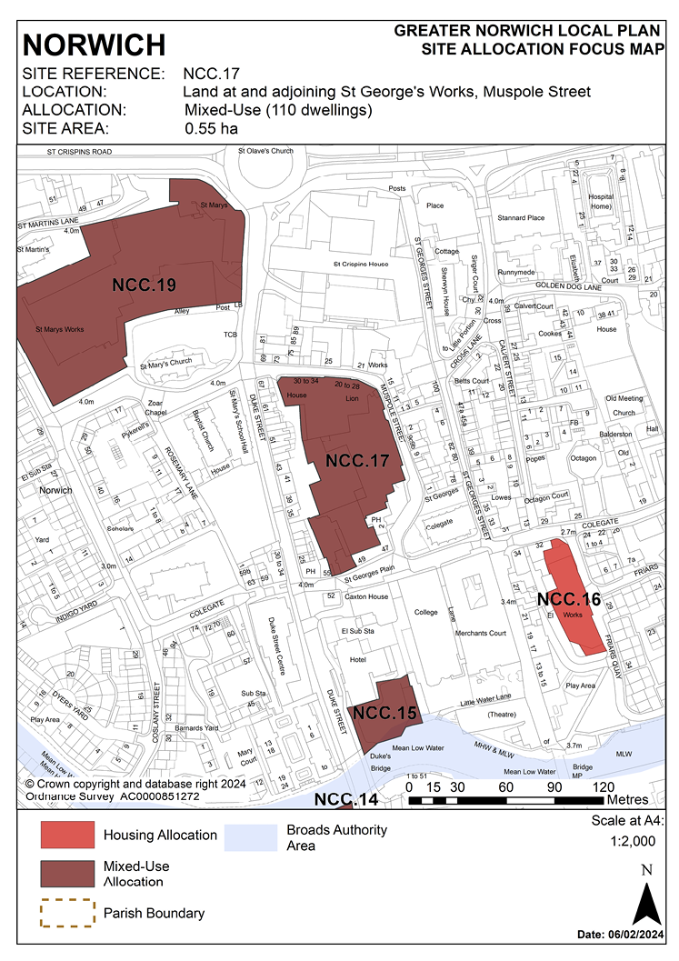
POLICY NCC.17
Land at and adjoining St Georges Works, Muspole Street, Norwich
3.143 The St Georges’ Works site includes Seymour House and Lion House, Muspole Street and premises known as the Guildyard, Colegate which were historically part of the shoe factory complex so are included in the allocation. The Guildyard and Seymour House have previously benefitted from prior approval consents for conversion to a total of 60 flats. The central part of the site was previously allocated for residential development (minimum 40 dwellings) in the now expired Northern City Centre Area Action Plan and a now expired permission was granted for a 53-dwelling scheme.
3.144 The site has significant longer-term potential for regeneration and additional housing delivery but currently acts as the base for a range of small start-up companies in modernised managed workspace. Retention of the existing employment space on-site is highly desirable as part of a wider initiative in the Northern City Centre Strategic Regeneration Area. Given the importance of retaining and extending employment opportunities in the city centre, it would not be appropriate to replace the existing employment uses in favour of housing. The policy consequently recognises that there is scope for a flexible mix of both, allowing for up to 110 homes as an indicative maximum including employment space as part of a balanced mix. It is unlikely that an ‘entirely residential’ or ‘entirely employment’ based scheme would be supported, but a proportion of both.
3.145 Development of the site must address a number of constraints including its location within the City Centre Conservation Area and the area of main archaeological interest, the relationship with neighbouring statutory and locally listed buildings, site ground conditions and possible contamination, critical drainage catchment area, flood risk/dry island issues.
3.146 The site can accommodate in the region of up to 110 homes dependent upon the proportion of other uses developed on the site.
POLICY NCC.17
Land at and adjoining St Georges Works, Muspole Street, Norwich (0.55 hectares) is allocated for comprehensive redevelopment. This has the potential to provide up to approximately 110 homes, or circa 5000sqm of commercial floor space that could incorporate offices and potentially other ancillary uses. The site should be redeveloped to provide a mix of both residential and commercial activity.
The development will achieve the following site-specific requirements:
- Retention and conversion of the existing former factory buildings on-site subject to demonstrating a proposal’s viability, and deliverability.
- New build development, if proposed, to achieve a high-quality locally distinctive design which reinstates a strong built frontage along the west side of Muspole Street; that conserves and, where opportunities arise, enhances the significance of the City Centre Conservation Area and nearby designated heritage assets, including 47 and 49 Colegate and the Woolpack Public House, all listed at Grade II, including any contribution made to that significance by the setting.
- Impacts of proposed development on existing residents and local businesses, including pubs, to be minimised.
- Key views toward the tower of St. Georges Colegate to be protected and enhanced.
- High-quality landscaping and biodiversity enhancements to be provided on- site, with scope for off-site contributions to public realm improvements and the creation of a new pedestrian square between Muspole Street and St. Georges Plain.
- Reduced levels of residential car parking to achieve low car or car-free housing development in accordance with 2 – Sustainable Communities is appropriate to be provided in this location.
- The site is located within the area of main archaeological interest. An archaeological assessment will be required as part of a planning application.
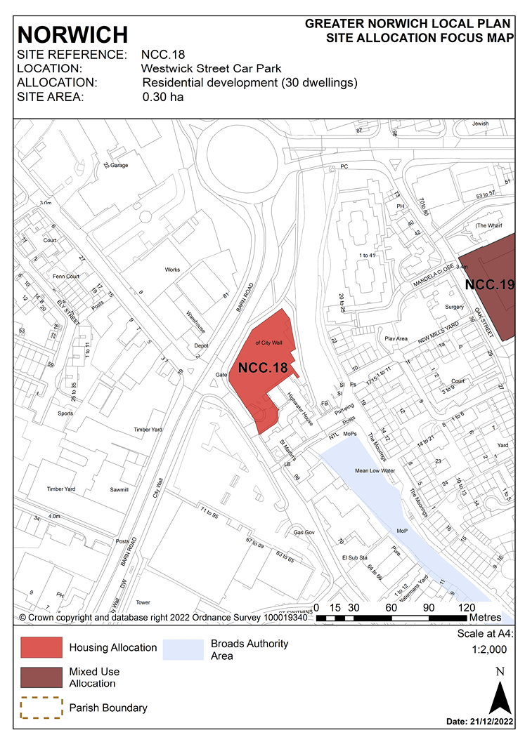
POLICY NCC.18
Westwick Street Car Park, Norwich
3.147 The site was allocated in the previous local plan but has not yet been developed. As evidence has shown it is deliverable, the site is re-allocated for residential development for around 30 homes in this plan.
3.148 This 0.3 hectare site is currently occupied by a surface car park accessed from Westwick Street, a route into the city centre from the inner ring road. It is bordered by the ring road to the north and west, by the River Wensum and the riverside walk to the east and by a residential night shelter to the south-east. Parking for neighbouring retail units is to the south.
3.149 The site is a gateway to the city centre, located adjacent to the remains of the city wall, close to the former Heigham Gate and the former City Station.
3.150 Redevelopment of the site offers the opportunity to make better use of this valuable city centre site to continue the development of a vibrant mixed-use quarter providing further housing in Westwick Street, and to extend the riverside walk.
3.151 As a main gateway, the quality of buildings here has a major impact on impressions of the city centre. High density development would be appropriate on the site, possibly of 3 or 4 storeys fronting Barn Road but stepping down to 2 or 3 adjacent to Highwater House and the river. A prominent corner building may be appropriate as part of a development scheme.
3.152 Development should address the site’s constraints. The site should be designed to take account of the height of neighbouring buildings and views of churches from the Barn Road roundabout. As the line of the former city wall runs across part of the site, this should be demarcated.
3.153 The City Centre Conservation Area appraisal identifies the river and the riverside walk to the east of the site as providing positive vistas. Development should retain and if necessary, improve footways around the site, linking to the neighbouring pedestrian and cycle network, and investigate the possibility of extending the riverside walk so that there is direct access to New Mills Yard. The development should seek to enhance the security and setting of the riverside walk.
3.154 New Mills Pumping Station near the site is Grade II listed. Given its location adjacent to the remains of the city wall, which is a scheduled ancient monument, the site may have archaeological interest; therefore an archaeological assessment is required prior to development on this site. Appropriate historic interpretation information should be incorporated in the development.
3.155 Development proposals will need to take account of noise from the neighbouring inner ring road; a noise assessment is required to inform the layout and design specification of development. Vehicular access should be from Westwick Street only and should take account of access to the Cathedral Retail Park opposite and the junction of Barn Road.
3.156 The site lies adjacent to the River Wensum. It is recommended that developers engage in early discussions with the Environment Agency.
3.157 The site is within flood risk zone 2; therefore, a flood risk assessment will be undertaken for this site and appropriate mitigation measures should be provided as part of the development.
3.158 The site lies within a critical drainage catchment. Therefore, development proposals involving new buildings, extensions and additional areas of hard surfacing should ensure that adequate and appropriate consideration has been given to mitigating surface water flooding.
3.159 Given the site’s location adjacent to the inner ring road and proximity to Grape’s Hill, which has acknowledged air quality issues, an air quality assessment will be required prior to development.
3.160 The site is likely to accommodate approximately 30 homes.
POLICY NCC.18
Westwick Street Car Park, Norwich (0.30 hectares) is allocated for residential development. This will accommodate approximately 30 homes.
The development will achieve the following site-specific requirements:
- Achievement of a high-quality, locally distinctive, and flood resilient design of a scale and form which has regard to its prominent gateway location within the city centre.
- Conserve and, where opportunities arise, enhance the setting of the City Wall Scheduled Monument, adjacent Grade II listed pump house (including any contribution made to their significance by setting). Scale and massing of the proposed development will enhance key views from and into the City Centre Conservation Area.
- Provide linkages through the site to the adjoining pedestrian network, including a connection with the riverside walk in accordance with policy 7.1 and the ‘River Wensum Strategy’.
- Vehicular access should be taken solely from Westwick Street.
- Heritage interpretation, particularly of the city wall, to be provided on-site.
- The site is located within the area of main archaeological interest. An archaeological assessment will be required as part of a planning application.
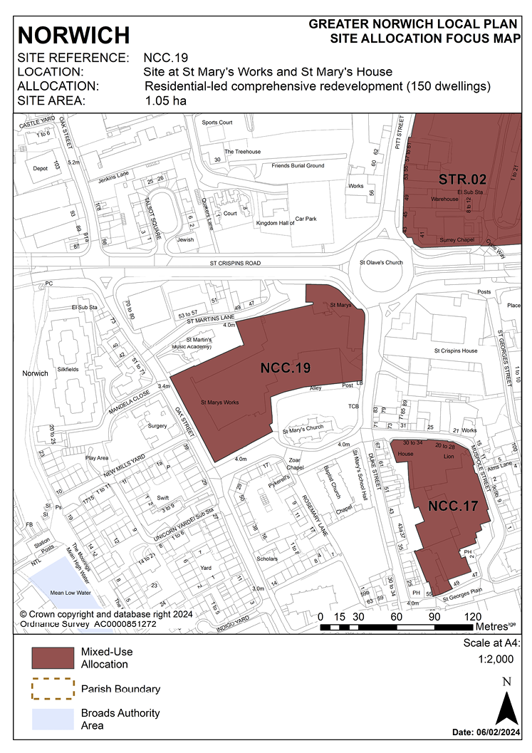
POLICY NCC.19
Site at St Mary’s Works and St Mary’s House, Norwich
3.161 St Mary’s Works and St. Mary’s House is a city centre brownfield site measuring 1.05 hectares which adjoins two Grade I listed medieval churches and their churchyards, St Mary’s Church to the south fronting St Marys Plain and St Martin’s Church to the north fronting Oak Street and St Martins Lane. The site consists of the locally listed early 20th century former Sexton, Son and Everard Ltd shoe factory (St. Mary’s Works) which is on the east side of Oak Street and on St Marys Plain to the south. The remainder of the site is occupied by a series of 20th century offices, workshops and warehouses.
3.162 There is a high concentration of heritage within and in proximity to the site. Designated heritage assets include listed buildings and the City Centre Conservation Area; non-designated heritage assets include locally listed buildings and the area of main archaeological interest.
3.163 There are further heritage assets within close proximity of the site, which may also be impacted by proposed development. Designated heritage assets include listed buildings at Pykerells House on Rosemarys Lane listed Grade II*, 47 and 49 St Martins Lane, 57, 59 and 61 Duke Street, 67 Duke Street and 69 -89 Duke Street listed Grade II and locally listed buildings include the Zoar Baptist Chapel St Marys Plain, St Marys School Hall and 43, 45, 47-49, 51- 55 Duke Street. Depending upon the scale of any proposals, further heritage assets may also be affected. A comprehensive heritage statement and heritage impact assessment will be required in support of any proposals.
3.164 The site is located within the City Centre Conservation Area, with the majority of the site and its heritage assets located in the ‘Colegate Character Area’ and the north-eastern corner of the site occupied by a 20th century office building being located in the ‘Anglia Square Character Area’.
3.165 Mature trees within the churchyards are protected by conservation area status.
3.166 The site is situated within the area of main archaeological interest; this area offers potential to reveal more about the history of the early city. It is likely that the archaeological potential across the whole site will be of interest. Archaeological investigation below any areas of construction or altering of the ground will likely be required to assist in the understanding of the city.
3.167 The site is situated in a prominent location within the Northern City Centre Strategic Regeneration Area, as defined in policy 7.1 of this plan, and is likely to accommodate approximately 150 homes. The site was previously allocated in the now expired Northern City Centre Area Action Plan for mixed-use development and had (now expired) outline consent for redevelopment including around 151 residential units, office floor space, and a hotel. The expired consent included landscaping enhancements to the adjacent churchyards of St. Martin at Oak and St. Mary Coslany along with improved public access to address the impact of development. This land sits outside the allocation boundary of this site and is in third party ownership; but similar proportionate off-site enhancements subject to agreement with third party ownership may be considered appropriate mitigation for a future development proposal on this site.
3.168 Development of the site must address a number of constraints including its location in the City Centre Conservation Area and area of main archaeological interest, the relationship with neighbouring statutory and locally listed buildings and gateway to the city, site ground conditions, possible contamination, risk of flooding from flood zone 2 and surface water flooding. A noise impact assessment and air quality assessment will be required, and the development must be designed to mitigate the impact of noise from the main road.
POLICY NCC.19
The site at St. Mary’s Works and St. Mary’s House, Norwich (1.05 hectares) is allocated residential-led comprehensive redevelopment including employment uses. The site will deliver approximately 150 homes.
The development will achieve the following site-specific requirements:
- Achievement of a high-quality, locally distinctive design of a scale and form which respects its historic and industrial context, the significance and setting of heritage assets on and off-site, and the character and appearance of the City Centre Conservation Area.
- There will be a general presumption in favour of the repair and reuse of heritage assets on-site as part of any site regeneration, however any application for redevelopment will be considered on its merit. Proposals will include the protection of the locally listed buildings on the site and conserve and, where opportunities arise, enhance the significance of the designated and non-designated heritage assets both on and off-site (including any contribution made to that significance by setting).
- Conversion of the locally listed St. Mary’s Works factory, including the façade of the locally listed frontage to Oak Street / St. Mary’s Plain, should be retained as part of a development scheme. Proposals which seek to convert, alter or demolish the locally listed buildings or have a harmful impact on the significance of their setting will be considered on their merits. Clear justification for all proposals will be required.
- Respect the setting of Grade I listed St. Martin at Oak and St. Mary Coslany churches and create enhanced views of the buildings and respect the setting of Grade II listed Folly House and Pineapple House.
- Development proposals should draw upon local character and distinctiveness and preserve or enhance the character and appearance of the conservation area.
- Proposals will be required to adopt and implement a strategy of heritage interpretation.
- Achieve high-quality landscaping, planting, and biodiversity enhancements.
- Ensures a level of surface water flood resilience and incorporates appropriate flood mitigation measures addressing identified risks from surface water flooding.
- A noise impact assessment and air quality assessment will be required, and the development must be designed to mitigate the impact of noise from the main road.
- The scale of buildings fronting onto St Martin’s Lane and the two historic churches will be lower than those facing Duke Street and St Crispin’s Road and should reflect the tight urban grain of development predominant in the conservation area.
- Increased connectivity between the site and the surrounding townscape. Pedestrian and cycle access through the area will be created by the design of routes between St Mary’s Plain and St Crispin’s Road.
- Reduced levels of residential car parking to achieve low car or car-free housing in accordance with 2 – Sustainable Communities is appropriate to be provided in this location.
- The site is located within the area of main archaeological interest. An archaeological assessment will be required as part of a planning application.
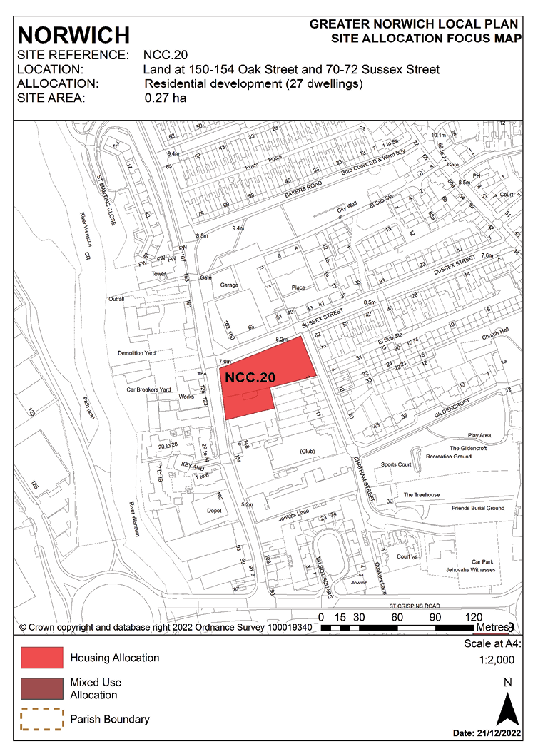
POLICY NCC.20
Land at 150-154 Oak Street and 70-72 Sussex Street, Norwich
3.169 This allocation consists of land that was allocated in the previous local plan as two separate sites. The site is an amalgamation of previous site allocation CC19 along with part of CC18 (the northern area at 150-154 Oak Street); this land is now all in a single ownership. The southern area of previous allocation CC18 (134 Oak Street and 140-148 Oak Street) is in separate ownership and was not carried forward into the GNLP. The northern part fronting Sussex Street, previously CC19 was allocated for 15 homes and had consent for 17 homes intended to be delivered as a co-housing scheme; that consent has now expired unimplemented. CC18 was previously allocated for 10 homes.
3.170 There is a current planning application, reference 22/00762/F, for a cohousing development pending determination which covers the same boundary as the proposed allocation. As evidence has shown it is deliverable, the site is re-allocated for residential development in this plan.
3.171 The site is bounded by Oak Street to its west, Sussex Street to the north and Chatham Street to the east. There is housing surrounding the eastern side of the site and commercial uses to the west and south, along with the listed Great Hall on the opposite side of Oak Street.
3.172 The site provides the opportunity for new housing on a brownfield site with excellent access to jobs and services in the city centre and neighbouring shopping facilities at Anglia Square/St. Augustine’s/Magdalen Street large district centre.
3.173 The City Centre Conservation Area appraisal identifies the site as being part of the “Northern Riverside” area of the city centre, in which former industrial and commercial uses are steadily being converted to or replaced by housing. The Oak Street area north of the ring road is particularly identified as a major development opportunity.
3.174 Mid-19th century terraced houses to the east of the site on Sussex Street and Chatham Street are locally listed and houses further east on Sussex Street are listed. The appraisal identifies the rest of Sussex Street as a positive frontage and as one of the most interesting streets of its type in the city centre. Chatham Street beyond the site is identified as providing a positive vista towards landmarks within the city centre. The Great Hall, west of the site on the opposite side of Oak Street, is a 15th century Grade II listed building.
3.175 Redevelopment of this site represents an opportunity to reinstate the historic building line along Sussex Street, as well as Oak Street and Chatham Street. This will complete the terrace on the south of Sussex Street and provide an improved setting for the Great Hall listed building. In addition development may need to address possible contamination issues. Consideration should be given to retaining the willow tree, the importance of which is highlighted in the appraisal, on the street frontage.
3.176 The location of the site within the area of main archaeological interest requires an archaeological investigation to be carried out prior to development.
3.177 The site is served by an off-site combined foul and surface water sewer. Adoption of this facility into a proposed drainage strategy must be pre-agreed with the appropriate management company.
3.178 The site is likely to accommodate approximately 27 homes.
POLICY NCC.20
Land at 150-154 Oak Street and 70-72 Sussex Street, Norwich (0.27 hectares) is allocated for residential use. This will accommodate approximately 27 homes.
The development will achieve the following site-specific requirements:
- Achievement of a high-quality, locally distinctive design of a scale and form which conserves and, where opportunities arise, enhances its location within the City Centre Conservation Area and nearby listed buildings (including Grade II listed Great Hall) (including any contribution made to their significance by setting) and secures an improvement in townscape.
- Create strong built frontages to Oak Street, Sussex Street and Chatham Street, if feasible, reinstating historic layouts by grouping buildings around an internal courtyard.
- The site is located within the area of main archaeological interest. An archaeological assessment will be required as part of a planning application.
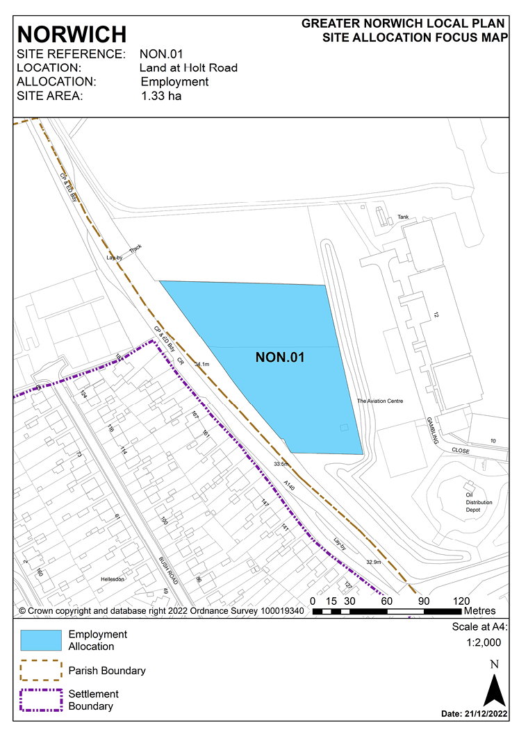
POLICY NON.01
Land at Holt Road, Norwich
3.179 This site comprises 2 paddocks and was previously allocated in the Norwich Site Allocations and Site-Specific Policies plan for either:
- an extension to the airport, where justified in an airport masterplan produced and endorsed by Norwich City Council within two years from adoption of that plan (by December 2016), or
- for general employment uses.
3.180 A masterplan for Norwich Airport was not produced within that time period. A masterplan has subsequently been produced and was endorsed by the city council in October 2019. This does not identify the land at Holt Road as required for airport related uses.
3.181 The site has extant planning consent for vehicle hire which has commenced on-site.
3.182 Taking account of the above, this plan allocates the site for general employment purposes.
3.183 Norfolk Minerals and Waste Core Strategy policy CS16 applies, as this site is underlain by safeguarded minerals resources. The benefits of extracting the minerals, if feasible, will be taken into consideration.
POLICY NON.01
Land at Holt Road, Norwich (1.33 hectares) is allocated for general employment purposes (use classes E(gii/iii), B2 and B8).
The development will achieve the following site-specific requirements:
- Provide vehicular access to the site from Gambling Close or from a single point of access onto Holt Road serving the entire site, providing this can be achieved without unacceptable impacts on highway safety or the free flow of traffic.
- Promote sustainable transport to the site.
- Provide appropriately for servicing, parking and other transportation requirements.
- Demonstrate (through a noise impact assessment) that appropriate account has been taken of the potential impacts of noise from existing and proposed airport operations and noise generation from the development itself.
- Incorporate suitable boundary treatment screening to the Holt Road frontage and mitigation measures to reduce the impact of the development on the outlook and living conditions of adjoining and nearby residents.
- Ensure that any development is designed having regard to the requirements of Norwich Airport with regard to Airport safeguarding measures.
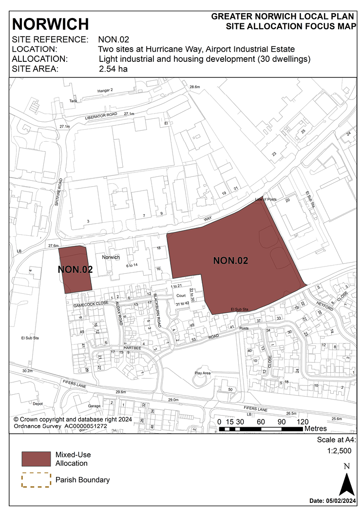
POLICY NON.02
Two sites at Hurricane Way, Airport Industrial Estate, Norwich
3.184 These sites were allocated in the previous local plan but have not yet been developed. As evidence has shown the sites are deliverable, they are re-allocated in this plan for light industrial and housing development. The scope for residential development on the eastern part of the site will be dependent on addressing impacts on residential occupiers from existing or proposed employment uses.
3.185 The Airport Industrial Estate is located to the north and adjoining parts of the earlier defence site now form part of the industrial estate. The remainder of the former student accommodation has been developed for housing. Development will help provide more opportunities for small and start-up businesses (units below 1,500 square metres).
3.186 The development will have to address specific on-site constraints relating to its former uses and location. A contamination assessment will be necessary.
3.187 Design of the development at site A must take account of its location neighbouring woodland. The design of sites A and B must also take account of trees on-site.
3.188 Vehicular access to the development sites for employment uses will be from Hurricane Way. A bus route and an improved pedestrian and cycle route will be provided through site B by the developer and will link Hurricane Way to the northern end of Heyford Road, most likely on the sites eastern boundary. The cycle route will be part of the yellow route of the strategic cycle network. The development should be designed to provide surveillance of this route to ensure it will be safe.
3.189 These sites are likely to accommodate approximately 30 homes.
POLICY NON.02
Two sites at Hurricane Way, Airport Industrial Estate, Norwich (Site A, land north of Gamecock Close and west of 6-14 Hurricane Way, (0.26 hectares) and Site B, land between Hurricane Way and Stirling Road, (2.28 hectares) are allocated for light industrial and housing development. This will accommodate approximately 30 homes.
The development will achieve the following site-specific requirements:
- Development should be approached in the context of a comprehensive masterplan for the Airport Industrial Estate as a whole.
- Achievement of a high-quality, locally distinctive design which provides for effective integration of the residential elements of any scheme with adjoining housing, segregation of proposed housing from surrounding employment areas and effective separation of residential and non-residential uses and flood-resilient design (including addressing identified risks from flooding from surface water flooding).
- Housing, if proposed on Site B, will be appropriate if in accordance with a comprehensive masterplan (to be produced). Vehicular access to be taken from Heyford Road.
- Residential development on Site A will be dependent on demonstrating that a suitable vehicular access can be achieved from the south via Gamecock Close.
- Light industrial development and/or small business uses on the frontage to Hurricane Way are acceptable providing they are not significantly detrimental to adjoining neighbouring residential occupiers.
- A high-quality landscaping scheme is required which provides for the protection of trees on-site and the provision and enhancement of green infrastructure and biodiversity links.
- Provision for retention of the north-south pedestrian and cycle link (that form part of the yellow pedalway) and bus link from Hurricane Way to Heyford Road via Site B.
- Be designed to mitigate the impact of noise generation, light and odour pollution from adjacent industrial uses and Norwich International airport.
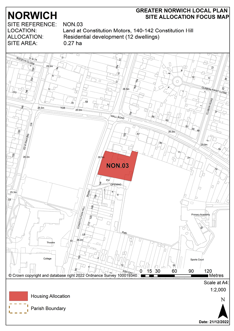
POLICY NON.03
Land at Constitution Motors, 140-142 Constitution Hill, Norwich
3.190 This 0.27-hectare site is currently vacant, most recently occupied by a vehicle garage and showroom. It is bounded to the west by Constitution Hill, close to the junction with Wall Road to the north, by school playing fields to the east and residential development to the south.
3.191 The site is well located in relation to school provision and local convenience stores.
3.192 The site is expected to accommodate approximately 12 homes. A mix of dwelling sizes would be appropriate. The site lies within a critical drainage catchment. Therefore, development proposals involving new buildings, extensions and additional areas of hard surfacing should ensure that adequate and appropriate consideration has been given to mitigating surface water flooding.
3.193 The site has extant planning permission for residential development in accordance with the allocation.
POLICY NON.03
Land at Constitution Motors, 140-142 Constitution Hill (0.27 hectares) is allocated for residential development. This will provide approximately 12 homes.
The development will achieve the following site-specific requirements:
- Achievement of a high-quality, locally distinctive and energy efficient design of a scale and form which is in keeping with local character, respects and enhances the heritage significance of the adjoining locally listed former public house and preserves the trees on the eastern boundary and open setting of the playing fields to the rear.
- High-quality landscaping, planting, and biodiversity enhancements including the provision of new trees and enhancing the green frontage to Constitution Hill.
- Addressing and remediating potential contamination from previous motor trade uses.
- Low-car development in accordance with policy 2 is appropriate in this location as it is on a high frequency bus route.
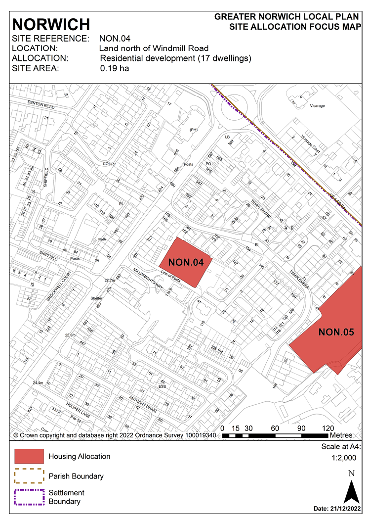
POLICY NON.04
Land north of Windmill Road, Norwich
3.194 The site was allocated in the previous local plan and has been subject to planning permission for a development of 17 homes which has been implemented. As evidence has shown it is deliverable, the site is re-allocated for residential development providing a comparable number of homes to the approved scheme.
3.195 The site is in the north of the city and is 0.18 hectares in size. Windmill Road links Sprowston Road and Templemere via a privately owned and unsurfaced track.
3.196 The site is surrounded by housing which is a mixture of 2 storey semi-detached housing and Victorian terraces. There are 3 storey flats adjacent to the north of the site and some new housing close to the foodstore on the adjacent site.
3.197 The foodstore has enlarged and strengthened the Sprowston Road/Shipfield neighbourhood shopping centre and enabled its reclassification from a local to a district centre, so that it can better meet the area’s day to day needs for top-up shopping. Housing development will additionally aid regeneration and will benefit from its location close to the centre and the excellent public transport links.
3.198 Development proposals must address the site’s constraints. These include undertaking ground conditions and contamination surveys and an archaeological assessment.
3.199 The design of the development must take account of the differing land levels within the site, its sloping nature and on-site trees.
3.200 Sprowston Road is part of the major road network and is a core bus route. A new access to Sprowston Road has been provided as a result of the implemented permission on the adjacent site. Linking into this new access would enable Windmill Road to be retained as an un-surfaced track offering pedestrian and cycle friendly links to Anthony Drive and Templemere.
3.201 Assessment and protection of on-site trees will be required followed by a scheme of landscaping to enhance site linkages.
3.202 The site lies within a critical drainage catchment. Therefore, development proposals involving new buildings, extensions and additional areas of hard surfacing should ensure that adequate and appropriate consideration has been given to mitigating surface water flooding.
POLICY NON.04
Land north of Windmill Road, Norwich (0.19 hectares) is allocated for residential development. This will accommodate approximately 17 homes.
The development will achieve the following site-specific requirements:
- Achievement of a high-quality, locally distinctive design.
- Design to take account of differences in level between the site and adjoining residential properties and effectively addresses potential issues of overlooking loss of privacy and surface water flooding.
- Vehicular access to the site should be taken from the south via Millwright’s Way, with pedestrian access retained via Windmill Road and links to Windmill Court and Templemere retained and enhanced.
- Protection and enhancement of key green infrastructure, biodiversity and geodiversity assets within the site including replacement of trees on-site, addressing the impact of adjacent trees on the site, and provision of a high-quality landscaping scheme.
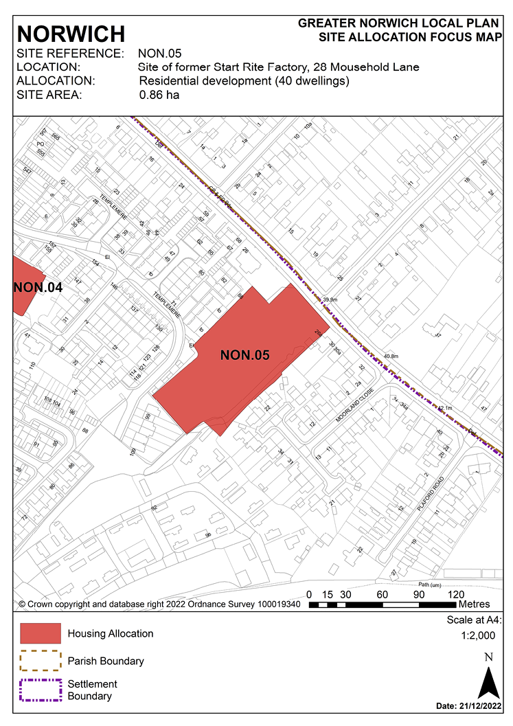
POLICY NON.05
Site of former Start Rite Factory, 28 Mousehold Lane, Norwich
3.204 The site was allocated in the previous local plan. It has an extant planning consent which has been implemented and is partially completed. It is re-allocated for residential development in this plan and is likely to accommodate approximately 40 homes.
3.205 The site is located on the south-west side of Mousehold Lane (the A1042) between Sprowston Road and Moorland Close. Mousehold Lane forms part of the Norwich outer ring road and is on a principal distributor route serving the northern and eastern suburbs and major employment areas around the airport and Sprowston. The site extends to 0.87 hectares and slopes down from north-east to south-west.
3.206 The surrounding area is predominantly residential with low and medium density housing areas adjoining the site on three sides. Further housing on the opposite frontage to Mousehold Lane on its north-east side is within Sprowston in Broadland district. Immediately adjoining the site to the north-west is a former 1930s pub, the Duke of Norfolk, now converted to a restaurant.
3.207 The south-eastern boundary of the site is steeply banked up to the rear gardens of properties in Moorland Close. Additionally, there is a reserved strip of land for an easement and right of way for services alongside the south-western boundary adjoining residential properties in Templemere.
3.208 A medium density housing development is appropriate on this brownfield site close to local services. The site has unconstrained capacity for approximately 60 dwellings. In practical terms the constraints imposed by site levels and easements, the need to respect the suburban character of the surrounding area and minimise overlooking to Templemere will reduce the achievable maximum number of dwellings to around 40. Development should include a mix of dwelling sizes and types with a maximum of three storey building height.
3.209 The existing belt of woodland and scrub which runs along the length of the south-west and south-east boundaries of the site should be retained and opportunities taken to enhance landscaping and green infrastructure through the site. This belt forks to the south-east and south-west, thereby linking to Mousehold Heath and towards the Sprowston Road allotments. There is the potential for this belt to function as a biodiversity corridor to extend to Mousehold Heath. In terms of visual amenity it represents a significant landscape feature which should be retained and enhanced.
3.210 A pedestrian link to Templemere is desirable to provide a more convenient and direct link to the district retail centre. Vehicular access should be taken from Mousehold Lane with appropriate junction improvements to enable a right turn for eastbound traffic using Mousehold Lane and a pedestrian crossing point.
3.211 Investigation has shown evidence of some contamination from previous industrial uses which will require remediation prior to commencement of development. Traffic noise and possibly noise from the adjacent restaurant use could be an issue on the Mousehold Lane frontage and appropriate sound insulation measures and suitable layout of development will be required to overcome any amenity impacts.
3.212 The site lies within a critical drainage catchment. Therefore, development proposals involving new buildings, extensions and additional areas of hard surfacing should ensure that adequate and appropriate consideration has been given to mitigating surface water flooding.
3.213 If developed for older persons housing, affordable housing contributions should be in accordance with the requirements set out in policy 5 – Homes.
POLICY NON.05
Site of former Start Rite Factory, 28 Mousehold Lane, Norwich (0.86 hectares) is allocated for residential development which may be provided either as general needs housing or care home development. This will accommodate approximately 40 homes.
The development will achieve the following site-specific requirements:
- Achievement of a high-quality, locally distinctive design which responds to its prominent location on the outer ring road.
- The design must address the topography of the site and surface water drainage issues.
- A pedestrian/cycle link to Templemere should be provided.
- Retain the existing belt of woodland and scrub on south-west and south-east boundaries and enhance landscaping and green infrastructure through the site.
- Vehicular access should be taken from Mousehold Lane. Development should provide for all necessary highway and junction improvements to enable a right turn into the site and the integration and enhancement of the existing pedestrian crossing point.
- Consideration should be given to rationalising access/servicing arrangements to enable a single shared access to adjoining commercial premises at 26 Mousehold Lane and remove the need for a separate access.
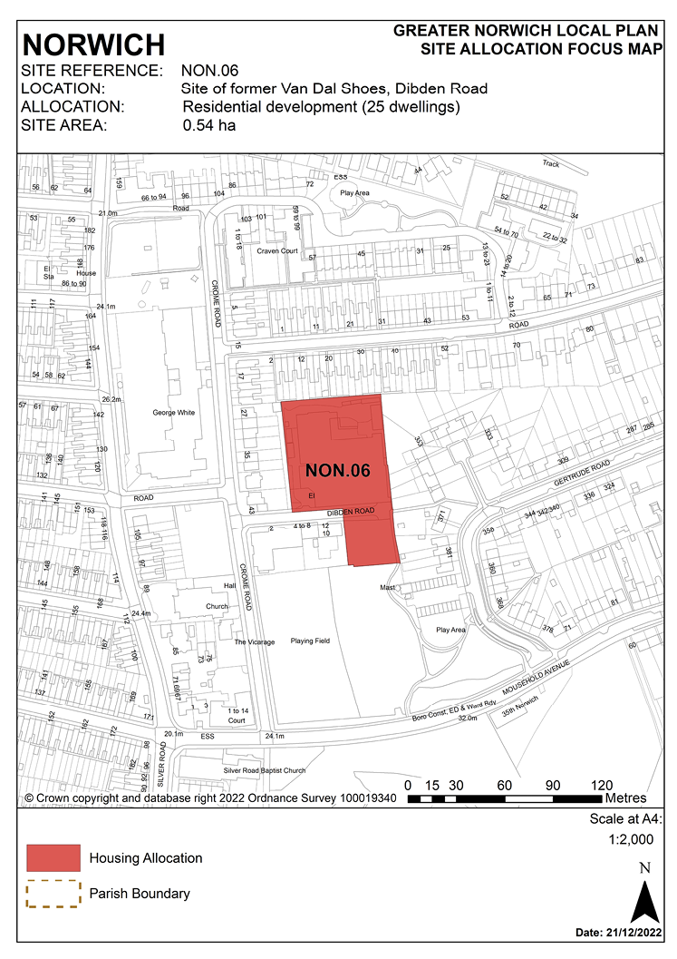
POLICY NON.06
Site of former Van Dal Shoes, Norwich
3.214 The site was allocated in the previous local plan but has not yet been developed. Since evidence has shown that the site is deliverable, it is re-allocated for residential development in this plan.
3.215 This brownfield site consists of two storey industrial buildings with associated outbuildings on the northern part of the site and a surface parking area to the south. There is an adopted road central to the site which splits the two areas of land and the sites including the road extend to 0.54 hectares. The site is currently vacant, most recently used as a shoe factory with a factory retail outlet. The historic factory backs onto the footpath along Dibden Road. This site is located in a residential area largely surrounded by a mixture of terraced houses and flats. There is a hostel development to the south-west of the site and open space to the south.
3.216 The site provides the opportunity for new housing on a brownfield site with excellent access to employment opportunities and services in the city centre and nearby shopping facilities on Sprowston Road and at the Anglia Square large district centre. Housing development is suitable on this site within a predominantly residential area.
3.217 The heritage significance of existing locally listed buildings should be recognised and assessed to consider whether they are suitable for conversion in part or whole. Following assessment, development should involve either conversion of the existing locally listed buildings or redevelopment if this is not practical. If redeveloping the site, the heritage significance of the locally listed buildings should be recorded and included on the heritage environment record. Some form of heritage interpretation to commemorate the former use of the site would be appropriate in redevelopment proposals. New development should be designed to integrate well with surrounding housing and to make the best of the potential for views over the city.
3.218 Prior to development, assessment and remediation of any possible contamination should take place. Development must also take account of the existing electrical sub-station fronting Dibden Road and the mast on the open space to the south. Consideration should also be given to the retention of trees in the north of the site which provide amenity value to this part of the site and wider area.
3.219 Development will need to address access issues including the potential stopping up or diversion of the highway. Existing pedestrian links should not be affected, and pedestrian and cycle links should be enhanced, linking to Mousehold Avenue and Gertrude Road, providing a link to the pink route of the strategic cycle network. Footpath access to Gertrude Road from the end of Dibden Road should be retained.
3.220 A contamination assessment and any necessary mitigation measures are required.
3.221 The site lies within a critical drainage catchment. Therefore, development proposals involving new buildings, extensions and additional areas of hard surfacing should ensure that adequate and appropriate consideration has been given to mitigating surface water flooding.
3.222 The site is likely to accommodate approximately 25 homes.
POLICY NON.06
Site of former Van Dal Shoes, Dibden Road, Norwich (0.54 hectares) is allocated for residential development. This will accommodate approximately 25 homes.
The development will achieve the following site-specific requirements:
- The existing locally listed shoe factory building should be retained or converted, subject to viability. To this end an assessment of its suitability for conversion either in part or as a whole (taking account of the industrial heritage significance of the site) will be required.
- Where new buildings are proposed they should achieve high-quality, locally distinctive design of a scale and form which reflects its prominent location and the character and context of the surrounding predominantly residential area.
- Development should be designed to integrate well with the surrounding housing and to make the best of the potential for views over the city.
- Site contamination arising from the former manufacturing use should be addressed and mitigated.
- Address access issues, including the potential stopping up or diversion of the highway subject to maintaining a pedestrian link across the site.
- Provide enhanced pedestrian and cycle links to Mousehold Avenue and Gertrude Road.
- Be designed to promote biodiversity and facilitate green infrastructure links to neighbouring green spaces and connections to Mousehold Heath. Existing trees on-site should be retained and protected where practicable.
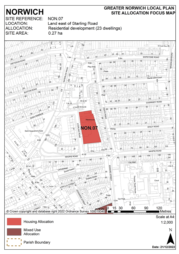
POLICY NON.07
Land east of Starling Road, Norwich
3.223 A larger site including land immediately to the north was allocated in the previous local plan for 45 homes. This has been partially delivered with the completion of 22 apartments on the former Cordova Buildings site. Part of the remainder of the allocation east of Starling Road has a planning permission (18/00271/F) which has been implemented and remains extant. The remaining part of the site is also expected to be developed within this local plan’s time-period. Consequently, the site is re-allocated for residential development to deliver approximately 23 homes, the anticipated capacity of the remaining land.
3.224 The site provides the opportunity for new housing on a brownfield site in a predominantly residential area, with excellent access to employment opportunities and services in the city centre and neighbouring shopping facilities at the Anglia Square large district centre.
3.225 Development should address the site’s constraints which include heritage issues, access arrangements, noise and contamination.
3.226 Development should be designed to integrate well with surrounding existing and new housing development. Street frontages to Starling Road should be reinstated. Although not in a conservation area, this site abuts the northern boundary of the City Centre Conservation Area and the terraced housing immediately to the south on Magpie Road which is locally listed; therefore any development will need to be designed to complement recent development in the area and the setting of the conservation area and be of an appropriate scale, form and massing and to take account of existing historic assets. The site is located close to the line of the former city wall and is within the area of main archaeological interest. An archaeological investigation will be required prior to its development.
3.227 Noise generation from road traffic to the south and between existing industrial/commercial users and new residential development must be addressed and due to previous industrial uses, a contamination assessment will be required.
3.228 The site lies within a critical drainage catchment. As such, all development proposals involving new buildings, extensions and additional areas of hard surfacing should ensure that adequate and appropriate consideration has been given to mitigating surface water flooding.
3.229 The site is likely to accommodate approximately 23 homes.
POLICY NON.07
Land east of Starling Road, Norwich (0.27 hectares) is allocated for residential development. This will accommodate approximately 23 homes.
The development will achieve the following site-specific requirements:
- Achievement of a high-quality, locally distinctive design which establishes a strong built frontage to Starling Road.
- The design should take account of heritage issues including its location on the fringe of the City Centre Conservation Area and locally listed terraces on Magpie Road.
- Site contamination arising from current and former industrial and motor trade uses should be addressed and mitigated.
- Noise generation from road traffic and existing industrial and commercial uses should be addressed and mitigated.
- Incremental development may be accepted where it would not compromise the development of the remainder of the site.
- As the allocation site is within multiple ownerships, shared access points should be provided to keep the number of access points to a minimum.
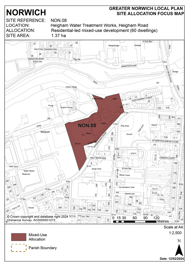
POLICY NON.08
Heigham Water Treatment Works, Waterworks Road, Norwich
3.230 This part of the water treatment works is identified as surplus to Anglian Water’s operational needs and is planned to be decommissioned. The site, on a larger boundary, was allocated in the previous local plan but has not yet been developed. As evidence has shown that development can take place within this local plan’s time-period up to 2038, the site is re-allocated for residential-led mixed-use development and public open space on a reduced boundary.
3.231 The majority of the site is within flood zone 2, whilst a small part of the site is in flood zone 3a. A site-specific flood risk assessment will need to be completed prior to the planning application stage. The area falling within flood zone 3a must not be developed for housing; instead, it should be included in the landscaping and open space provision. Since the site is over 1 hectare, a flood risk assessment is required, and appropriate mitigation measures should be provided as part of the development.
3.232 Development of the site will only be possible subsequent to decommissioning and will require consultation with the Health and Safety Executive. Development should take into account possible site contamination.
3.233 This site is a regionally important “industrial garden”, as identified by the Norfolk Historic Gardens Survey. An archaeological survey is required before any development takes place, and the design of the development should seek to retain the special characteristics of the site. Three buildings on-site, Eastgate House, Pump House 1 and Pump House 2, are locally listed; these should be retained for reuse or converted to residential uses.
3.234 The site is likely to accommodate approximately 60 homes.
3.235 Norfolk Minerals and Waste Core Strategy policy CS16 applies, as this site is partially underlain by safeguarded minerals resources. The benefits of extracting the minerals, if feasible, will be taken into consideration. Parts of the site are within the consultation area for a safeguarded waste management site and Norfolk Minerals and Waste Core Strategy policy CS16 applies while the waste site is active.
POLICY NON.08
Heigham Water Treatment Works, Waterworks Road, Norwich (1.37 hectares) is allocated for housing led mixed-use development and public open space. This will accommodate approximately 60 homes.
The development will achieve the following site-specific requirements:
- Achievement of a high-quality, locally distinctive, and flood-resilient design (including addressing identified risks from flooding from rivers and surface water flooding).
- The design must reflect the prominent riverside location and provide for the retention and enhancement of heritage assets within the site including the historic boundary wall on Waterworks Road; the locally listed Pump House 1 and Eastgate Lodge; as well as heritage assets adjacent to the site including the locally listed Pump House 2 buildings and Grade II listed/scheduled monument St. Bartholomew’s Church, Heigham.
- A small element of business or commercial use is acceptable subject to uses being compatible with the continuation of water treatment operations on the adjoining site to the west and subject to any required variation or revocation of hazardous substance consents pertaining to those operations.
- Approximately 60 homes will be provided, depending on the appropriate mitigation measures undertaken, including the provision of adequate and appropriate access to the site.
- The land adjoining the River Wensum will provide a public open space with a publicly accessible riverside walk in accordance with policy 7.1 and the ‘River Wensum Strategy’ and subject to water security considerations.
- A high-quality landscaping scheme is required which provides for the protection of trees on-site and the provision and enhancement of green infrastructure and biodiversity links.
- Contamination from existing uses on-site should be assessed and mitigated.
- An archaeological assessment will be required prior to development.
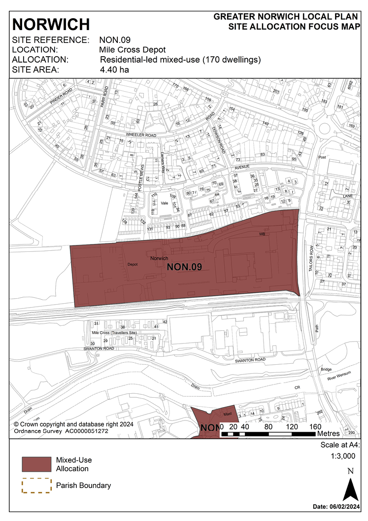
POLICY NON.09
Mile Cross Depot, Norwich
3.236 The site was allocated in the previous local plan for a mixed-use development of up to 75 homes and employment uses. Current aspirations for this council-owned site are to deliver a substantially increased number of homes, alongside associated community uses. Since evidence has shown that such proposals are deliverable, the site is allocated in this plan for residential-led mixed-use development which may include associated community uses.
3.237 The former City Care depot site is in the west of the city and is 3.65 hectares in size. The site was previously used as a council depot and for a variety of linked uses, including offices, vehicle repair workshops and storage. The site has been cleared in preparation for development.
3.238 The site is close to existing residential developments at Valpy Avenue to the north and on the other side of Mile Cross Road. The site is predominantly flat, with the site level rising significantly to the north. The railway path (part of the Marriot’s Way), which is a key cycle route and part of the green link network, runs along the southern boundary of the site. Adjacent to the site on the far side of the railway path are business buildings and the Gypsy and Traveller site at Swanton Road.
3.239 This surrounding area is dominated by a mixture of industrial and residential uses. The industrial areas are however fragmented and are increasingly being redeveloped for housing. Mile Cross Road is part of the major road network and is a radial road to the west of the city.
3.240 This allocation provides an opportunity to make more efficient use of the site, providing opportunities for housing development and associated community uses.
3.241 The loss of some employment land on the site will be outweighed by the wider regeneration benefits to this part of the city through a comprehensive housing scheme creating enhancements of and better access to green infrastructure within this area.
3.242 The development will need to overcome a number of constraints. The site is adjacent to the valley of the River Wensum which is an important environmental asset. It is also close to the Sweet Briar Road Meadows which is a Site of Special Scientific Interest. Development proposals should be designed to preserve and enhance biodiversity.
3.243 There are a number of trees and habitats adjacent to the site which should be protected and enhanced.
3.244 The site is partially covered by flood zone 2 and is greater than 1 hectare in size; it therefore requires a flood risk assessment and appropriate mitigation measures should be provided as part of the development. Other constraints include possible contamination and possible ground condition issues.
3.245 Development proposals must take account of the site’s location within the outer zone of the Health and Safety Executive consultation area for Heigham Waterworks and Bayer Crop Science. Site layout and disposition of uses should reflect this.
3.246 As the adjacent railway path is a key element of the city’s cycling network; the design of development should be permeable, enabling pedestrian / cycle links through the site to connect with the route.
3.247 Mile Cross Road is already a busy road and not capable of handling a significant increase in traffic from residential development. Access issues need to be addressed as part of a planning application.
3.248 The site is likely to accommodate approximately 170 homes.
3.249 Norfolk Minerals and Waste Core Strategy policy CS16 applies, as this site is partially underlain by safeguarded minerals resources. The benefits of extracting the minerals, if feasible, will be taken into consideration.
POLICY NON.09
Mile Cross Depot, Norwich (4.40 hectares) is allocated for residential-led mixed-use development which may include associated community uses. This will accommodate approximately 170 homes. The final number of homes delivered will depend upon the scale of any community uses delivered.
The development will achieve the following site-specific requirements:
- Achievement of a high-quality, locally distinctive design which reflects its prominent location on the edge of the river valley, the setting of the adjoining Mile Cross Conservation Area and the proximity of formal and informal recreational open space.
- High-quality green infrastructure, landscaping, planting, and biodiversity enhancements should be provided including formal and informal public and private open spaces within the site.
- The southern frontage of the site to Marriott’s Way should be enhanced and landscape and pedestrian and cycle links provided through the site to link with the existing recreational route.
- Potential contamination from previous uses on-site, potential geological issues should be assessed and mitigated.
- Vehicular access should be taken from Mile Cross Road with emergency access and pedestrian/cycle links provided to Valpy Avenue.
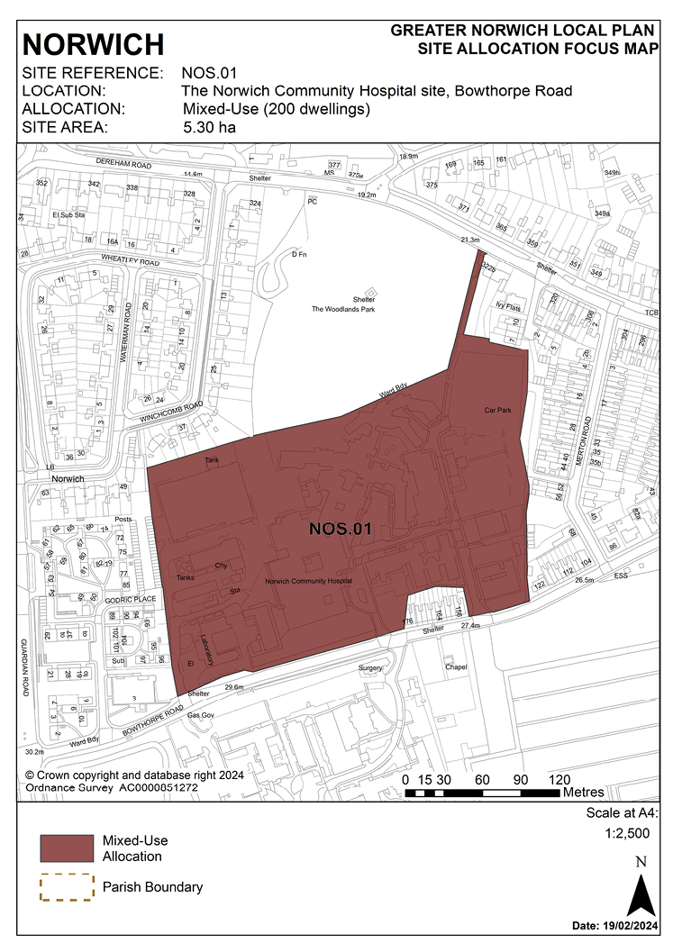
POLICY NOS.01
The Norwich Community Hospital site, Bowthorpe Road, Norwich
3.250 Part of this site was allocated in the previous local plan for 80 homes in the expectation that it would be disposed of for development as part of the future rationalisation and redevelopment of the hospital. Although these redevelopment plans are still being progressed, the area of land considered surplus to NHS requirements has been reassessed and part of the original local plan allocation site is now identified for continued healthcare use under proposals since granted outline planning permission.
3.251 Revised proposals for redevelopment of the main part of the hospital site make provision for key worker housing and housing for older people which is expected to address part of the housing need originally to have been met from the development of the local plan allocation site.
3.252 Accordingly, the site is re-allocated in this plan on a larger boundary for a mix of uses including residential development. The mix of uses will be subject to review depending on evidence of needs provided by the NHS Trust.
3.253 The outline consent granted in late 2021 has the potential to deliver approximately 190 homes or ‘equivalent homes’ as demonstrated under the initial proposals of the 2018 planning application; however, the final mix of homes and healthcare development may change. The 2021 approval did not encompass the whole site and the remaining part could accommodate around 50 dwellings. Any future “departure” from a core housing figure would be assessed against any social or health care benefits which might arise from dependent upon securing future funding (i.e., more health care facilities than housing). If developed wholly for residential use, the site may accommodate approximately 250 homes.
3.254 Norfolk Minerals and Waste Core Strategy policy CS16 applies, as this site is partially underlain by safeguarded minerals resources. The benefits of extracting the minerals, if feasible, will be taken into consideration.
POLICY NOS.01
The Norwich Community Hospital site, Bowthorpe Road, Norwich (5.30 hectares) is allocated for mixed-use development. This may include hospital development and ancillary activities, plus associated supported living, care and key worker accommodation, and residential development. As part of a mixed-use scheme the site may accommodate around 200 homes depending on the level of healthcare development.
The development will achieve the following site-specific requirements:
- Development should be approached in the context of a comprehensive masterplan for the Norwich Community Hospital site and should be consistent with and complementary to mixed-use redevelopment proposals agreed in principle for the existing hospital.
- Achievement of a high-quality, locally distinctive design which reflects the prominent location of the site on the frontage to Bowthorpe Road and the proximity of formal open space and informal recreational open space including Earlham Cemetery and Woodlands Park.
- Retention of the locally listed Woodlands House.
- Conserve and enhance the setting of the adjacent Earlham Cemetery Grade II Registered Park and Garden and nearby Jewish Mortuary Chapel heritage assets.
- Provide pedestrian and cycle links between Bowthorpe Road and Dereham Road via the Woodlands Park to the north of the site and to Godric Place.
- High-quality green infrastructure, landscaping, planting, and biodiversity enhancements should be provided including formal and informal public and private open spaces within the site and the retention and enhancement of existing trees. Biodiversity links between the site and neighbouring green spaces will be protected and enhanced.
- Site contamination and geotechnical constraints should be assessed and mitigated.
- The design and configuration of development should have regard to the siting of existing telecommunications equipment on-site.
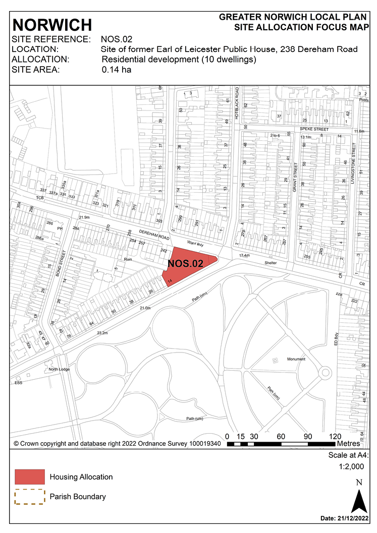
POLICY NOS.02
Site of former Earl of Leicester Public House, 238 Dereham Road, Norwich
3.255 The site was allocated in the previous local plan. It also had a planning permission which has since lapsed but has not yet been developed. Since evidence has shown that the site can be delivered, it is re-allocated for residential development.
3.256 The former public house on this site of 0.14 hectares was demolished in 2005 and the site has been vacant since.
3.257 This site is at the busy junction of the A1074 Dereham Road and Bowthorpe Roads, with housing to its north and west. Earlham Cemetery, a significant open space, historic park and County Wildlife Site, is opposite to its south.
3.258 Development of this brownfield site will enable new housing to be provided in a sustainable location in a mainly residential area on the Dereham Road bus rapid transit route.
3.259 Design of the development should have regard to the prominent position in the townscape at this busy junction. It must be designed to make best use of this triangular site, have safe access at a major road junction, maximise private amenity space and must minimise road traffic noise for future residents.
3.260 Given the site’s proximity to the neighbouring Earlham Cemetery it must also enhance the setting of this space, which is part of a green corridor identified in the Green Infrastructure Delivery Plan and provides local cycle routes.
3.261 Vehicular access should be from Bowthorpe Road in the south-west corner of the site.
3.262 The site is served by an off-site combined foul and surface water sewer to its north. Adoption of this facility into a proposed drainage strategy must be pre-agreed with the appropriate management company.
3.263 The site is likely to accommodate approximately 10 homes.
POLICY NOS.02
Site of former Earl of Leicester Public House, 238 Dereham Road, Norwich (0.14 hectares) is allocated for residential development. This will accommodate approximately 10 homes.
The development will achieve the following site-specific requirements:
- Achievement of a high-quality, locally distinctive design which reflects its prominent landmark location on a road junction and enhances the setting of the adjoining Earlham Cemetery.
- Development should be designed and configured to protect the amenity and outlook of existing adjoining and future residents, including adequate amenity space and mitigation of the impact of road traffic noise.
- Reduced levels of residential car parking to achieve low car or car-free housing development in accordance with policy 2 – Sustainable Communities is appropriate to be provided in this location adjacent to the planning mobility hub at the junction of Dereham Road and Hotblack Road.
- Vehicular access, if provided, should take account of the proximity of the traffic light-controlled junction.
- Heritage interpretation will be required reflecting the previous use of the site.
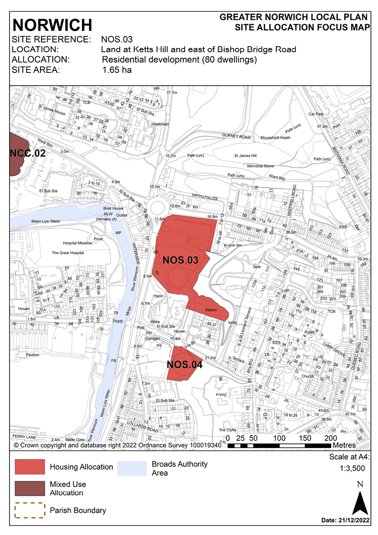
POLICY NOS.03
Land at Kett’s Hill and east of Bishop Bridge Road, Norwich
3.264 The site was previously identified as two separate allocations in the ‘Site allocations and site-specific policies’ plan, site R14 (Land East of Bishop Bridge Road) and R15 (Land at Kett’s Hill and Bishop Bridge Road). The majority of the site still falls within a Health and Safety Executive hazardous installation consultation zone which is centred on the former gas storage site. As part of any future application, it should be demonstrated that National Grid has surrendered or revoked the hazardous substance consent. The site has not yet been developed. As evidence has shown that development can take place within this local plan’s time-period up to 2038, the site is accordingly re-allocated for residential development as a single allocation.
3.265 Development should respect the heritage significance and setting of the adjacent Thorpe Hamlet, City Centre and St. Matthews Conservation Areas. Design will have to take account of the site’s topography and must not have a negative impact on geodiversity or on views to and from the Thorpe Ridge - Kett’s Heights which is identified as an important long view in appendix 8 of the Development Management policies plan. 19th century walls on the Box and Barrell land are highlighted as being of importance in the conservation area appraisal. If possible, these should be retained as part of any future development. Kett’s Heights is also identified as part of a green infrastructure corridor. Therefore, the design of development must take account of existing trees on-site and create a habitat link to Kett’s Heights. The trees along the Kett’s Hill site frontage are subject to a tree preservation order (TPO No 430). These trees will need to be retained as part of any proposal and it should be demonstrated that they can be protected during the works. Tree cover also extends from the escarpment into the site and it is considered that this tree cover provides a visually soft transition between the nature geographic feature of the escarpment and the flatter areas of the river valley. This valuable woodland edge forms a key part in the conservation area and consideration would have to be given to what impact the proposed development would have on the woodland edge (and vice versa).
3.266 Provision for an additional access to Kett’s Heights through the allocation site should be provided. There will need to be an assessment of the levels and trees in this part of the site as it slopes up steeply from west to east, there is also gas infrastructure to consider, this will determine the best route into the site to link with existing routes. Steps will likely be required and should be of a durable construction such as UV stable recycled composite plastic, backfilled with type 1 and with a hoggin surface. A handrail will be required, and fencing may be required in some areas. Access should be gated to enable locking at dusk in line with other existing access points. A commuted sum would be required for maintenance of this access route.
3.267 The development will also have to address specific on-site constraints relating to its former uses and location. Decommissioning and demolition of existing structures will be required, and ground conditions and contamination assessments will be necessary. A noise impact assessment will be required, and design of the development must minimise the impact of noise from the inner ring road. An archaeological assessment will also be required.
3.268 Access to the majority of the site should be from the existing unused junction neighbouring 27 Bishop Bridge Road. Since this access point is likely to also be used to access the northern area of the site, development should be designed to enable this. Inclusion of the gas pressure reduction station means that the south-eastern part of the development could be accessed via William Kett Close.
3.269 As a minimum, protection and enhancement of geodiversity will include recording of on-site geological features.
3.270 Development needs to ensure that the water environment is protected. The site falls within source protection zone 1, designated to protect water supplies, therefore the water environment is particularly vulnerable in this location. Detailed discussions over this issue will be required with the Environment Agency to ensure that proposals are appropriate for the site and that the site is developed in a manner which protects the water environment. The site is served by an on-site combined foul and surface water sewer. Adoption of this facility into a proposed drainage strategy must be pre-agreed with the appropriate management company.
3.271 The site is likely to accommodate approximately 80 homes.
POLICY NOS.03
Land at Kett’s Hill and east of Bishop Bridge Road, Norwich (1.65 hectares) is allocated for residential development. This will accommodate approximately 80 homes.
The development will achieve the following site-specific requirements:
- Achievement of a high-quality, locally distinctive design of a scale and form which reflects and responds to its prominent location adjacent to the hillside east of the city centre and to Thorpe wooded ridge.
- Respect the heritage significance and setting of the adjacent Thorpe Hamlet, City Centre and St. Matthews Conservation Areas.
- Consider long views and vistas particularly taking into account key landmark buildings. Examples of important views are from Mousehold Heath and Kett’s Heights and the view of the Cathedral when coming down Kett’s Hill.
- Provide public access to Kett’s Heights.
- Protection and enhancement of key green infrastructure, biodiversity and geodiversity assets within the site including retention and enhancement of tree planting to its northern boundary fronting Kett’s Hill.
- Site contamination arising from the former gas storage use should be addressed and mitigated.
- Development will not take place prior to the revocation of the hazardous substance consent.
- The main vehicular access will be provided from Bishop Bridge Road.
- Reduced levels of residential car parking to achieve low car or car-free housing development in accordance with policy 2 is appropriate to be provided in this location.
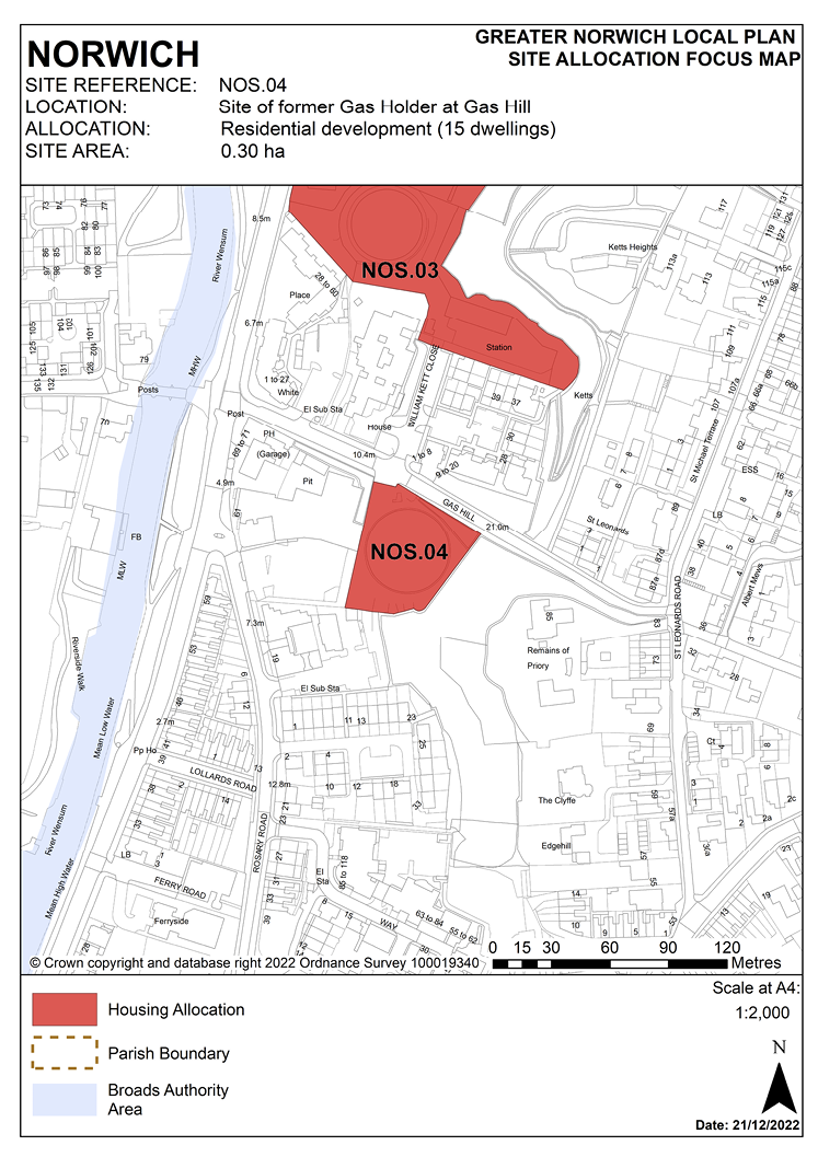
POLICY NOS.04
Site of former Gas Holder at Gas Hill, Norwich
3.272 The site was allocated in the previous local plan but has not yet been developed. As evidence has shown that development can take place within this local plan’s time-period up to 2038, the site is re-allocated for residential development.
3.273 The site is located to the east of the city centre, on the steep slope of Gas Hill. It is 0.3 hectares in size and is flat. The gas holder previously on-site has been decommissioned and removed.
3.274 The site is within an area with a mix of uses. It lies below the Thorpe wooded ridge, which includes the remains of the Benedictine St. Leonards Priory to its east. There is a pub, a furniture store and housing to the west and south, lower down the hill. There is also housing to the north of the site.
3.275 The site is between the St Matthews Conservation Area and the Thorpe Hamlet Conservation Area. The steepness of the chalk escarpment east of the site has prevented any major development, resulting in a ‘green wedge’ of trees and greenery, creating an important refuge for wildlife and open space. The ridge provides excellent views to and from the city centre, though there is no public access to the Thorpe wooded ridge at this point.
3.276 This brownfield site is in an accessible location for housing, close to Bishop Bridge local centre, the city centre, bus routes and the railway station.
3.277 Design will have to take account of the site’s topography and development must not have a negative impact on geodiversity or on views to and from the Thorpe wooded ridge.
3.278 The development will have to address specific on-site constraints relating to its former uses. Removal of the hazardous substance consent will be required. Ground conditions and contamination assessments will also be necessary.
3.279 As a minimum, protection and enhancement of geodiversity will include recording of on-site geological features.
3.280 Access to the site will be via the existing access from Gas Hill.
3.281 Development needs to ensure that the water environment is protected. The site falls within source protection zone 1, designated to protect water supplies, and therefore the water environment is particularly vulnerable in this location. Detailed discussions over this issue will be required with the Environment Agency to ensure that proposals are appropriate for the site and that the site is developed in a manner which protects the water environment.
3.282 The site is likely to accommodate approximately 15 homes.
POLICY NOS.04
Site of former Gas Holder at Gas Hill, Norwich (0.30 hectares) is allocated for residential development. This will accommodate approximately 15 homes.
The development will achieve the following site-specific requirements:
- Achievement of a high-quality, locally distinctive design of a scale and form which reflects and responds to its prominent location on the hillside east of the city centre adjacent to Thorpe wooded ridge. Development should blend in with the existing pattern of development in this location.
- Respect the heritage significance and setting of the adjacent Thorpe Hamlet Conservation Area and of the scheduled remains of St Leonards Priory. The site is in close proximity to Cow Tower scheduled monument, design of development on this site should preserve and, where opportunities arise, enhance the setting of adjacent heritage assets including the City Centre Conservation Area, and nearby Grade II listed buildings: Bridge House Public House and Chalk Hill House.
- Protection and enhancement of key green infrastructure, biodiversity and geodiversity assets within the site.
- Ensures a high level of flood resilience and incorporates appropriate mitigation measures addressing identified risks from surface water flooding.
- Development will not take place prior to the revocation of the hazardous substance consent.
- Site contamination arising from the former gas storage use should be addressed and mitigated.
- Reduced levels of residential car parking to achieve low car or car-free housing development in accordance with policy 2 – Sustainable Communities is appropriate to be provided in this location.
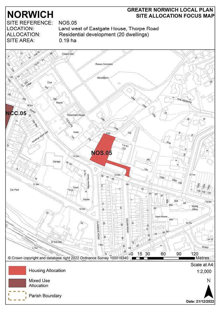
POLICY NOS.05
Land west of Eastgate House, Thorpe Road, Norwich
3.283 This 0.19 ha site to the east of Norwich city centre is currently occupied by a surface car park associated with Eastgate House accessed from Thorpe Road. It is bordered by the converted Graphic House (from office to student accommodation then to a hostel) to the west, by employment and residential uses to the north, by the converted (office to residential) Eastgate House to the east and by Thorpe Road to the south.
3.284 The site has a combined sewer within 100 metres of the southern boundary. Use of this asset in a drainage strategy for the site would be subject to permission from Anglian Water and therefore early consultation with Anglian Water is required. The site is in an area of Norwich with a significant number of internal and external flood incidences close by. This must be taken into consideration when designing a drainage strategy for the site and assessing surface water flood risk.
3.285 Development of the site must address a number of constraints including its location adjacent to the Thorpe Ridge Conservation Area, site ground conditions and its location adjacent to Rosary Cemetery registered parks and garden and Lion Wood, Telegraph Plantation and Rosary Cemetery County Wildlife Site.
3.286 The site is expected to accommodate approximately 20 homes. The site has been subject to previous outline proposals for residential development broadly in accordance with the allocation. Despite the refusal of an outline planning application in the absence of a mechanism to secure affordable housing, the principle of residential development is acceptable and is supported through this allocation.
POLICY NOS.05
Land west of Eastgate House, Thorpe Road (0.19 hectares) is allocated for residential development. This will provide approximately 20 homes.
The development will achieve the following site-specific requirements:
- Achievement of a high-quality, locally distinctive and energy efficient design of a scale and form which is in keeping with the character of adjoining development, respects the heritage significance of the immediately adjoining Thorpe Ridge Conservation Area and protects the amenity and outlook of adjoining residential occupiers.
- High-quality landscaping, planting, and biodiversity enhancements including the provision of new trees and enhancing the green frontage to Thorpe Road.
- Ensures a high level of surface water flood resilience and incorporates appropriate flood mitigation measures addressing identified risks from surface water flooding which must be taken into consideration when designing a drainage strategy for the site.
- Reduced levels of residential car parking to achieve low-car or car-free housing development in accordance with policy 2 - Sustainable Communities, is appropriate to be provided in this location.
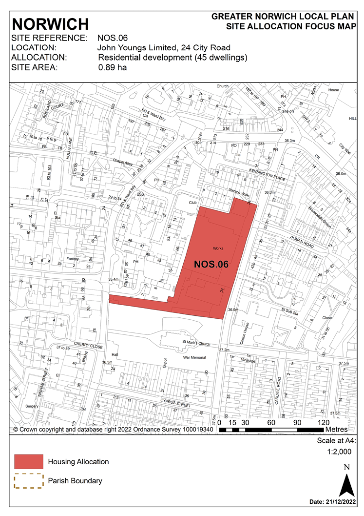
POLICY NOS.06
John Youngs Limited, 24 City Road, Norwich
3.287 The site was allocated in the previous local plan but has not yet been developed. It is re-allocated for residential development in this plan.
3.288 The site is 0.89 hectares in size and is currently occupied by John Youngs Ltd. for employment purposes. The buildings on-site comprise mostly functional industrial buildings, including buildings used for a machine-hire business, with some ancillary offices in the north of the site. There are trees and historic walls along the site’s southern boundary.
3.289 This site is between Hall Road and City Road in the south of the city and is in a predominantly residential area. There are terraced houses to the east and north of the site and flats to the west. The site borders the Grade II listed St. Mark’s Church and its churchyard to the south.
3.290 The site is close to the city centre and a range of facilities in the nearby local centre and is close to good public transport services; development will help enhance the character of the predominantly residential City Road area.
3.291 Development proposals must address the site’s constraints. On-site constraints include trees along the southern boundary, possible contamination and the need for demolition of existing buildings. The Victorian building in the north of the site has some heritage interest although it has been extensively altered and extended and consequently is neither statutorily listed nor on the city council’s local list. If viable, the option of retaining the building and converting it for residential purposes may be considered as part of comprehensive redevelopment of the site.
3.292 The design of the development must also protect and enhance the setting of St. Mark’s Church, including its graveyard and historic walls, protecting its value as a listed building, as an open space and its biodiversity and habitat value.
3.293 The site is close the orange route of the strategic cycle network in Hall Road. Development should provide a cycle and pedestrian link between Hall Road and City Road via the strip of land along the southern part of the site providing a connection through the site to local facilities in the wider area. Vehicular access should be from City Road. Its design should reduce the current number of access points onto City Road to improve highway safety within this area.
3.294 The site is likely to accommodate approximately 45 homes.
NOS.06
John Youngs Limited, 24 City Road, Norwich (0.89 hectares) is allocated for residential development. This will accommodate approximately 45 homes.
The development will achieve the following site-specific requirements:
- Achievement of a high-quality, locally distinctive design of a scale and form which reflects and responds to the residential character of the surrounding area.
- Respect the heritage significance and setting of the adjacent listed St. Marks Church and its graveyard and the surrounding locally listed residential terraces in City Road.
- Retain and convert the Victorian building in the north-east corner of the site for residential uses as part of the comprehensive development of the site, subject to viability.
- Reduced levels of residential car parking to achieve low car or car-free housing development in accordance with policy 2 – Sustainable Communities is appropriate to be provided in this location.
- Vehicular access if required should be taken from City Road. A pedestrian/cycle link will be provided between Hall Road and City Road.
- High-quality green infrastructure, landscaping, planting, and biodiversity enhancements should be provided as an integral part of the design of the scheme, to include protection of trees along the southern boundary and enhance the landscape setting of the site.
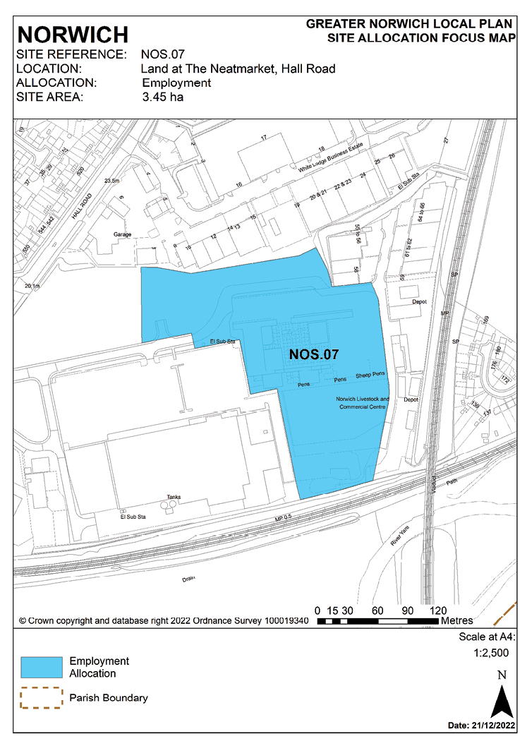
POLICY NOS.07
Land at The Neatmarket, Hall Road, Norwich
3.295 The site was allocated in the previous local plan for employment development. Part of the previous allocation has now been developed for car sales use. The remainder of the site has not yet been developed. As the potential to deliver further development has been evidenced, the site is re-allocated in this plan for employment use on a revised boundary.
3.296 The site is part of the former livestock market site and is 3.45 hectares in size. A gas storage facility is on the eastern part of the site and a Health and Safety Executive consultation zone exists around this part of the site. There are mature trees bordering the northern boundary of the site.
3.297 The access arrangements currently serving the site, including the Hall Road junction with Ipswich Road, may need to be upgraded to accommodate greater vehicle movements associated with any redevelopment, depending upon the nature and scale of the development proposed. Existing outline consent reference 18/0103/O indicates developer intentions to change the alignment of the access road to facilitate different sized development plots.
3.298 The site is neighboured to the north by commercial uses, with a mixture of business units, warehouses, and car showrooms. There is a large single storey retail unit to the south-west. The site borders railway lines to the south and east and there are houses and a hotel to the west of the roundabout on Hall Road which forms the entrance to the site. The site is within 250 metres of a former landfill site to the south.
3.299 Development must address the site constraints of potential contamination, risks associated with the proximity to hazardous substances (if a phased redevelopment is proposed), demolition of existing buildings, protection and/or replacement of trees on or adjacent to the site and noise due to proximity to the railway lines and wider impacts arising from the redevelopment itself on nearby housing in Tuckswood. Since the Yare Valley is a sub-regional green infrastructure corridor, the development will be required to provide a pedestrian and cycle link across the site from Hall Road to the River Yare riverside walk to the east. The route for this would exit the site in the south-east corner, go under the north/south railway bridge and alongside the east/west railway line, linking to Coopers Lane open space.
3.300 Norfolk Minerals and Waste Core Strategy policy CS16 applies, as this site is partially underlain by safeguarded minerals resources. The benefits of extracting the minerals, if feasible, will be taken into consideration.
POLICY NOS.07
Land at The Neatmarket, Hall Road, Norwich (3.45 hectares) is allocated for employment development and light industrial use (use classes B2/B8 and E(giii)). Ancillary office development and motor trade/car sales uses on the frontage to Hall Road will also be acceptable.
The development will achieve the following site-specific requirements:
- Achievement of a high-quality design.
- Takes account of the need to protect adjoining residential occupiers from noise from proposed uses and future occupiers of the development itself from noise from the railway.
- Piecemeal and/or phased development will be accepted only where it is demonstrated that retaining existing livestock market and ancillary uses on- site will not result in unacceptable impacts on future occupiers and where the access and operational needs of those retained uses can be adequately addressed.
- High-quality green infrastructure, landscaping, planting, and biodiversity enhancements should be provided including the retention of existing on-site and adjacent trees; development should make provision for mitigatory planting and appropriate enhancement.
- Potential contamination from previous uses and any risks arising from the proximity of the notifiable hazardous installation (Calor Gas) to the north should be assessed and mitigated.
- The construction of the main vehicular access road into the site as part of the first phase, incorporate a pedestrian and cycle link across the site to link with the Yare Valley Walk and the nearby Cooper Lane picnic area. Development shall provide a financial contribution towards off-site works to enable a pedestrian and cycle link across the site from Hall Road to link to the River Yare riverside walk.
- Development should make provision for any off-site improvements to the junction of Hall Road and The Neatmarket necessary as a result of increased traffic generation from the site.
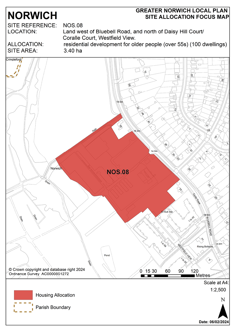
POLICY NOS.08
Land west of Bluebell Road, and north of Daisy Hill Court/Coralle Court, Westfield View, Norwich
3.301 The site was allocated in the previous local plan and has been partially developed with 62 retirement apartments (20 of them affordable) and 58 supported care units. Phase 1 has also provided public recreational use and long-term maintenance and management of open space at Strawberry Fields to the north of the site. As Phase 1 was delivered prior to the base date of the GNLP, this section of the site is not carried forward.
3.302 Allocation NOS.08 is for the remainder of the site. Phase 2, consisting of 50 units, is being built out.
3.303 Application 22/01447/F has been submitted and is pending consideration for phase 3. This application is for 23 bungalows, 74 apartments, ancillary communal facilities, landscaping, access, and associated works.
3.304 Accordingly, the site is re-allocated for residential development for older people and is considered likely to accommodate approximately 100 homes.
POLICY NOS.08
Land west of Bluebell Road, and north of Daisy Hill Court/Coralle Court, Westfield View, Norwich (3.40 hectares) is allocated for residential development for older people (over 55s). This will accommodate approximately 100 homes and/or elderly care accommodation planned as an extension to the existing development.
The development will achieve the following site-specific requirements:
- Achievement of a high-quality, locally distinctive design which reflects the sensitive and prominent location of the site in the Yare Valley and the adjoining Eaton Conservation Area.
- Development should minimise impact on the landscape of the Yare Valley and important views from and into the site.
- Development should deliver improvements to the strategic Yare Valley green infrastructure corridor, securing provision for 17.5 hectares of public open space on land adjoining the site and arrangements for its management and maintenance in perpetuity which will be provided for in the approved masterplan and planning obligations secured through legal agreement as part of the consented development. The public open space will provide improved pedestrian/cycle access to and within the valley, including improvements to the Yare Valley Walk.
- Protect and enhance environmental assets within and adjacent to the site, including the retention of tree belts.
- All dwellings should be built to the ‘M4(2) Accessible and Adaptable Standard Homes’ standard, of which a proportion should be built to M4(3) standard (fully wheelchair accessible).
UEA POLICIES
NOS.09, NOS.10, NOS.11 and NOS.12
3.305 This plan allocates three development sites at the University of East Anglia (UEA) campus which are expected to be developed for university related development and student accommodation within the local plan time-period up to 2038. In addition, the UEA Grounds Depot Site (NOS.12) is identified as a strategic reserve for future student accommodation development at the campus by the university. This reserve site will only be released after the completion of the development of the other sites allocated for student accommodation.
3.306 A revised Development Framework Strategy (DFS refresh) is being prepared by the UEA. Once finalised and endorsed by Norwich City Council as local planning authority, the DFS refresh will provide additional detailed evidence and guidance to inform development proposals for the specific sites allocated in this plan and for elsewhere in the campus.
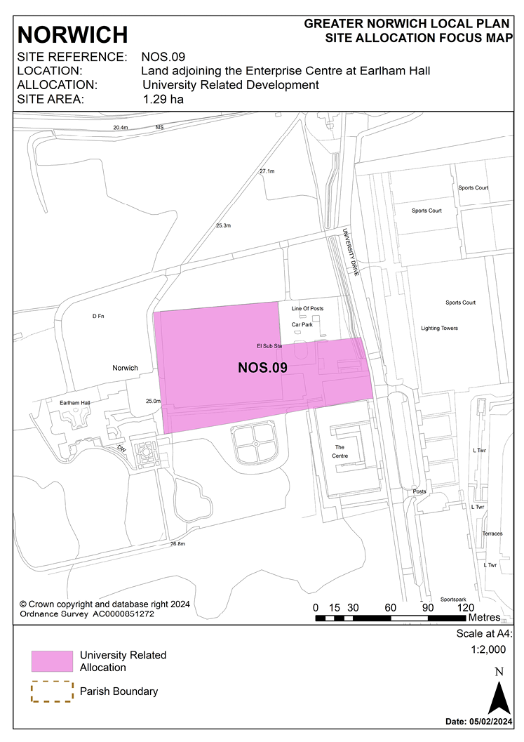
POLICY NOS.09
Land adjoining the Enterprise Centre at Earlham Hall (the walled garden and nursery), Norwich
3.307 This 1.06 hectare site comprises the walled garden to the east of Earlham Hall which was formerly used as a nursery and depot. The site does not include the public car park. A larger site was allocated in the previous local plan (R39) for business use. The first phase of development comprising the Enterprise Centre is complete and operating.
3.308 Development of the site must address a number of constraints including its location within the Earlham Conservation Area and neighbouring the Grade II registered Earlham Park historic park and garden and its proximity to the Grade II* listed Earlham Hall. Earlham Park is also part of the Yare Valley green infrastructure corridor.
3.309 Therefore, the design of development should both retain existing trees on and adjoining the site and create additional habitat links to the park. Sustainable drainage solutions will need to take account of the presence of protected habitats in the valley to the west of the site and within the site allocation area. Assessment will also be required of any archaeology interest which may remain. A contamination assessment and appropriate mitigation will be necessary.
3.310 Low rise development within the constraints of this sensitive setting is considered appropriate, as set out within the now lapsed outline planning permission for the site. Development meeting the future expansion needs of the university as detailed in the emerging Development Framework Strategy remains appropriate.
3.311 The site is allocated for development on this revised boundary for university-related uses to include offices, research and development and educational uses.
POLICY NOS.09
Land adjoining the Enterprise Centre at Earlham Hall (the walled garden and nursery), Norwich (1.29 hectares) is allocated for university-related uses, including offices (use class E(gi)), research and development (use class E(gii)) and educational uses (use class F.1) providing in the region of 5,000 square metres of floorspace.
The development will achieve the following site-specific requirements:
- Achievement of a high-quality, low carbon, and energy efficient development which respects its historic context.
- The need to conserve and, where opportunities arise, enhance the significance of the Grade II* Earlham Hall and associated Grade II listed buildings, the Grade II registered Earlham Park historic park and garden, and the Earlham Conservation Area (including any contribution made to that significance by setting), through careful design, massing and appropriate open space and landscaping. A heritage impact assessment should be undertaken, including the need for archaeological evaluation and recording, and regard should be had to the recommendations of the GNLP heritage statement (June 2021).
- Low rise development with high-quality landscaping, planting, and biodiversity enhancements to reduce the impact of built development, providing links to the river valley and integrating with the existing cycle and pedestrian network within the campus.
- Motor vehicular access should be taken from the existing access via University Drive.
- No additional car parking is to be created.
- Linking development to the university district heating network, where feasible and viable to do so, or providing alternative on-site facilities where these are considered to minimise impacts which might arise from connection to the national grid.
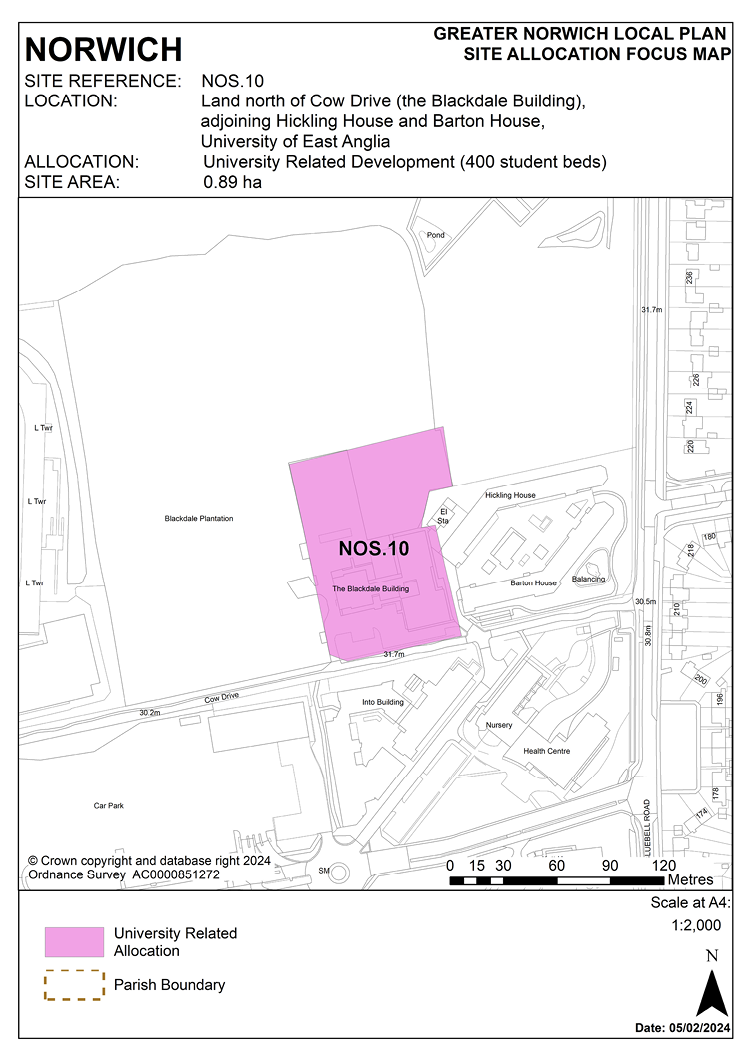
POLICY NOS.10
Land north of Cow Drive (the Blackdale Building, adjoining Hickling House and Barton House), at the University of East Anglia, Norwich
3.312 The allocated site is the former Blackdale School site which lies between Blackdale Plantation and Bluebell Road and is 0.89 hectares in size.
3.313 The site was allocated in the previous local plan (R40) on a larger boundary and benefits from a partly implemented planning permission for a 915-bed student accommodation development; the first 514-bed phase of which (Hickling House and Barton House) is complete. Should the second consented phase not proceed, development of a similar scale and form is appropriate in this location.
3.314 The woodland setting and existing landscape features should be retained and enhanced where appropriate. This includes Blackdale Plantation, the specimen trees occurring within the grounds, the boundary hedgerows and Cow Drive. Any changes to these areas will need to be informed by an arboriculture and landscape assessment. The site is likely to accommodate around 400 student bedrooms (equivalent to 160 homes for the purpose of housing forecast calculations).
3.315 There is an existing water main in Anglian Water’s ownership within the boundary of the site. This should be taken into account in the design of the development including safeguarding suitable access for maintenance.
POLICY NOS.10
Land north of Cow Drive (the Blackdale Building, adjoining Hickling House and Barton House), at the University of East Anglia, Norwich (0.89 hectares) is allocated for student accommodation development which may include a small element of ancillary university related uses. The site is expected to accommodate approximately 400 student bedrooms.
The development will achieve the following site-specific requirements:
- Achievement of a high-quality, locally distinctive, energy efficient design whose form and massing takes account of its location on the fringe of the campus, complements, and integrates with existing adjoining development and respects the design and heritage significance of the main part of the campus.
- High-quality landscaping, planting, and biodiversity enhancements to reduce the impact of built development, providing for the retention and enhancement of existing landscape features and the protection, enhancement, and management of and public access to the adjacent Blackdale Plantation.
- Linking development to the university district heating network, where feasible and viable to do or providing alternative on-site facilities where these are considered to minimise impacts which might arise from connection to the national grid.
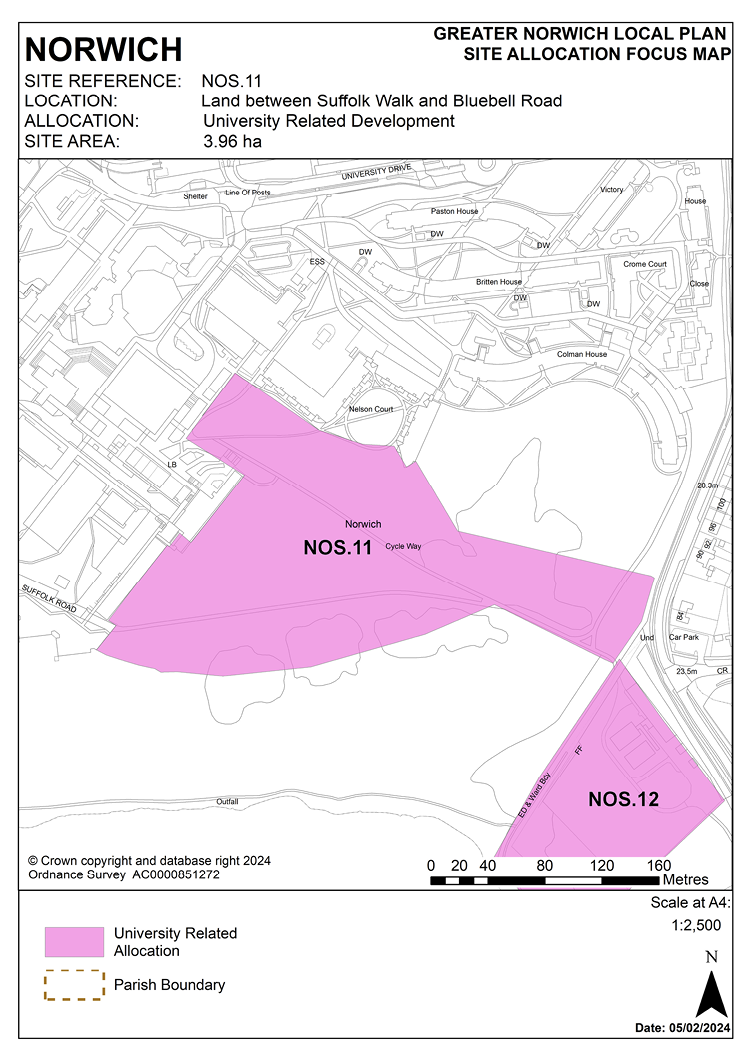
POLICY NOS.11
Land between Suffolk Walk and Bluebell Road
3.316 This 3.96-hectare site is in the south of the existing UEA campus and is west of Bluebell Road. Part of this site was identified in the previous Norwich site allocations and site-specific policies plan as a strategic reserve to accommodate the anticipated future expansion of the university.
3.317 The policy seeks to enable expansion of the university, whilst conserving the landscape and architectural significance of the UEA and promoting public access to open spaces. Therefore it is essential that development of the site minimises impact on the river valley and enhances the setting of the listed buildings at the university. Assessment will also be required of any archaeology interest which may remain. Consideration of the original Lasdun plan for a ‘Village on the hill’ will be important, as will design taking full account of other buildings of visual importance to the southern view of ‘The Prospect’, including the School of Music and Suffolk Walk. Intrusion into the valley should be limited to protect the valley’s appearance and use.
3.318 The sloping topography of the site presents an opportunity for the use of innovative, sustainable design to minimise the visual impact and maximise environmental performance, including linking the new development to the campus wide district heating network. Development should provide enhanced biodiversity links to the broad and river.
3.319 Public access to the University Broad from Bluebell Road, including cycle routes, must be retained and enhanced. Transport impacts assessment will be required as well as a review of the campus travel plan.
3.320 The potential development area identified provides an opportunity to complete the southern part of the campus. The emerging revised DFS considers that this development area has capacity to take a significant proportion of the demand for new university related floorspace and additional student accommodation over the plan period.
3.321 Norfolk Minerals and Waste Core Strategy policy CS16 applies, as this site is underlain by safeguarded minerals resources. The benefits of extracting the minerals, if feasible, will be taken into consideration.
POLICY NOS.11
Land between Suffolk Walk and Bluebell Road, (3.96 hectares) is allocated for university related development for both academic and non-academic uses.
The development will achieve the following site-specific requirements:
- Achievement of a high-quality, locally distinctive, energy efficient design whose form and massing takes account of and respects its location and will form a logical, coherent, integrated and coordinated extension on the fringe of the campus.
- Take account of its sensitive location adjoining the University Broad, protect the visual setting of the south elevations of “The Prospect” and conserve, and where opportunities arise, enhance the heritage significance and setting of the listed buildings within the campus, including the Grade II* Sainsbury Centre and Norfolk and Suffolk Terraces, Grade II listed Lasdun Teaching Wall and Library and locally identified Crescent Wing of the Sainsbury Centre, Suffolk Walk, School of Music, Drama studio and Nelson Court; balanced against having regard to Lasdun’s original architectural vision which must be a material consideration in its design. A heritage impact assessment should be undertaken, including the need for archaeological evaluation and recording, and regard should be had to the recommendations of the GNLP heritage statement (June 2021).
- High-quality landscaping, planting, and biodiversity enhancements to reduce the impact of built development, providing for the retention and enhancement of existing landscape features and improved public access to the University Broad and to local green space in the Yare Valley from this part of the campus; establishment and improvement of pedestrian and cycle routes across the site to connect with the existing cycle network.
- Access arrangements to the site to be informed by a transport assessment and updated travel plan. No vehicular access from Bluebell Road, access to be via existing university site only with access only for service vehicles and managed pick-up/drop-off for students for any residences provided.
- Existing foul and surface water sewers on-site to be considered as part of the site layout.
- Linking development to the university district heating network, where feasible and viable to do so or providing alternative on-site facilities where these are considered to minimise impacts which might arise from connection to the national grid.
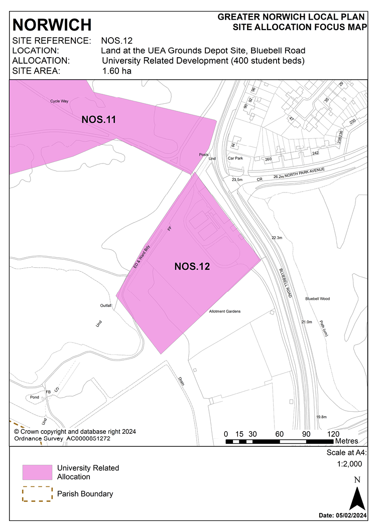
POLICY NOS.12
Land at the UEA Grounds Depot Site, Bluebell Road University of East Anglia – strategic reserve
3.322 This 1.60 ha site is located adjacent to the south-east of the existing university campus, located immediately to the east of the University Broad, between the broad and Bluebell Road. The site is currently occupied by the University Grounds Depot comprising a mixture of storage facilities and glasshouses.
3.323 The emerging revised DFS has identified that this site may be needed to meet growth needs up to 2038 for student accommodation. The site is on the slopes of the Yare Valley which is identified as a key green infrastructure corridor, providing both public access to the river and countryside along the Yare Valley Walk and important wildlife habitats. Open space neighbouring the site is protected from development as part of the Yare Valley under existing policy DM6 and as open space under policy DM8.
3.324 Therefore it is essential that development is sensitively designed to minimise effects on important views to and within the Yare Valley. Consequently, the type, scale, density and design of development will be designed to minimise impact on the landscape and preserve the character of the area. The site will be developed mainly at low densities to ensure that impact on the landscape is minimised; it is essential that development of the site minimises impact on the river valley and enhances the setting of the listed buildings at the university. Consideration of the original Lasdun plan for a ‘Village on the hill’ will be important. Intrusion into the valley should be limited to protect the valley’s appearance and use.
3.325 The site is allocated as strategic reserve land for long-term development to ensure that other sites within the campus are developed first ahead of the release of this site. The policy seeks to enable expansion of the university, whilst conserving the landscape and architectural significance of the UEA and promoting public access to open spaces.
3.326 The site is likely to accommodate around 400 student bedrooms, equivalent to 160 homes.
POLICY NOS.12
Land at the UEA Grounds Depot Site, Bluebell Road, University of East Anglia, Norwich – strategic reserve (1.60 hectares) is allocated for student accommodation development which may include a small element of ancillary university related uses. The site is expected to accommodate approximately 400 student bedrooms.
The development will achieve the following site-specific requirements:
- The land is identified as a strategic reserve for future development by UEA and should only be released subsequent to the completion of development of the Blackdale School site and Earlham Hall site and development of the Land between Suffolk Walk and Bluebell Road site.
- Achievement of a high-quality, locally distinctive, energy efficient design whose form and massing takes account of and respects its location on the fringe of the campus and adjoining the University Broad, complements and integrates with existing and proposed campus development and protects and enhances the heritage significance and setting of the listed buildings within the campus.
- Ensures a high level of flood resilience and incorporates appropriate mitigation measures; including addressing identified risks from flooding from rivers. Development must be sequentially located to flood zone 1 area of site.
- Generally low-rise development of 2 to 3 storeys will be required in this location to minimise impact on adjoining residential properties and established open space.
- High-quality landscaping, planting, and biodiversity enhancements to reduce the impact of built development, providing for the retention and enhancement of existing landscape features and the creation of a substantial green edge to the University Broad.
- Include an enhanced pedestrian and cycling connection through the site from Bluebell Road to the broad and linkages to and along the open river valley landscape to the south and east, linking to improved open space access at Bartram Mowers.
- Linking development to the university district heating network, where feasible and viable to do so or providing alternative on-site facilities where these are considered to minimise impacts which might arise from connection to the national grid.
- Development shall be car-free in accordance with 2, with access only for service vehicles and pick-up/drop-off for students and on-site car parking to be limited to disabled parking provision. Access arrangements to the site are to be informed by a transport assessment and updated travel plan including details of management of vehicle movements on arrival and departure days.
- Establishment and improvement of pedestrian and cycle routes across the site to connect with the existing cycle network and cycleway improvement at the site frontage.
- Existing foul and surface water sewers on-site are to be considered as part of the site layout.