Chapter contents
- POLICY STR.01 East Norwich Strategic Regeneration Area
- POLICY STR.02 Land at and adjoining Anglia Square, Norwich
- POLICY STR.03 Land known as ‘Site 4’ at Norwich Airport
- POLICY STR.04 Three Score, Bowthorpe, Norwich
- POLICY STR.05 Land adjacent to Norwich Research Park (NRP), Colney
- POLICY STR.06 Longwater Employment Area, Costessey
- POLICY STR.07 Land north of the A11, Cringleford
- POLICY STR.08 Land south and east of Easton
- POLICY STR.09 Land at the Royal Norwich Golf Club, either side of Drayton High Road, Hellesdon
- POLICY STR.10 Land off Blue Boar Lane/Salhouse Road, White House Farm, Sprowston
- POLICY STR.11 Land between Fir Covert Road and Reepham Road, Taverham
- POLICY STR.12 Land south and south-west of Lotus Cars, Hethel
- POLICY STR.13 Land north of Hethersett
- POLICY STR.14 Land east of the A140 and north of Norwich Airport, Horsham St Faith
POLICY STR.01
East Norwich Strategic Regeneration Area
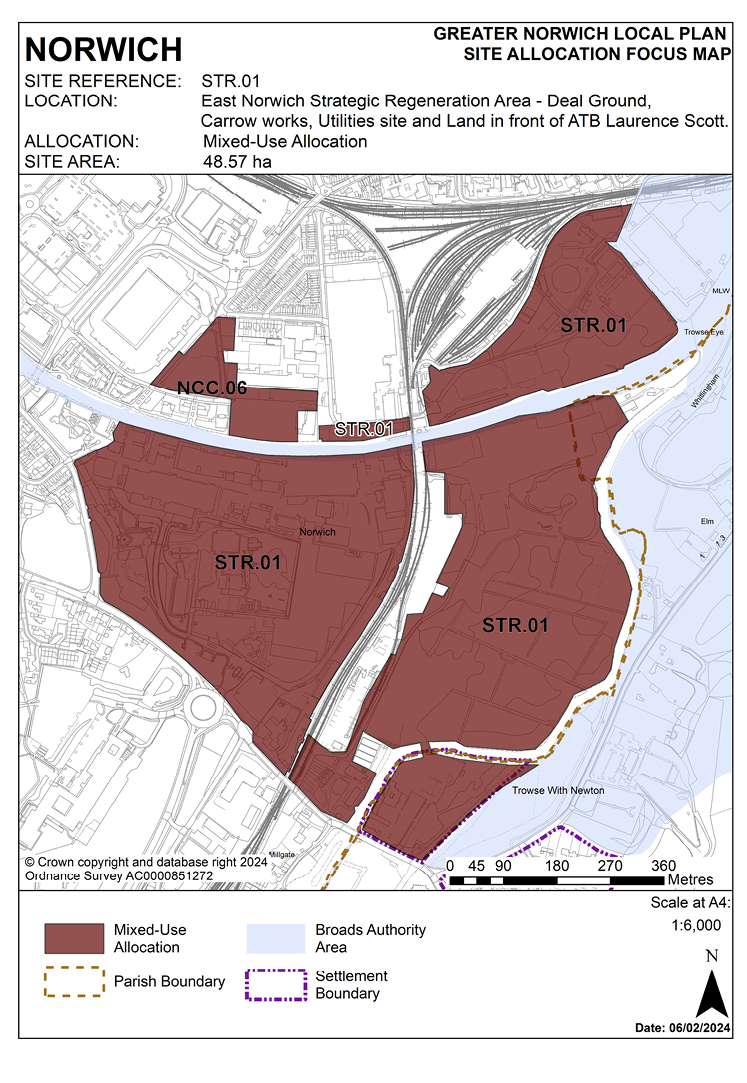
2.1 The East Norwich Strategic Regeneration Area (ENSRA) consists of three brownfield regeneration sites adjacent to the rivers Wensum and Yare. These are Carrow Works (including Carrow House), the Deal Ground (including the May Gurney site) and the Utilities Site. The ENSRA also includes land in front of ATB Laurence Scott fronting the Wensum which is considered essential for the delivery of sustainable transport links to the three sites and potentially for emergency access. The overall area is defined on map 9 of the Greater Norwich Local Plan and the three regeneration sites, (plus land in front of ATB Laurence Scott) are identified as a strategic regeneration area under policy 7.1 and allocated under this site allocations policy. This site allocations policy should be read in conjunction with policy 7.1.
2.2 The Deal Ground and Utilities Site were allocated in the Norwich Site Allocation and Site-Specific Policies Plan (2014) and these allocations are carried forward through this plan. The release of the Carrow Works site for development presents the opportunity to strategically address the challenges and opportunities of all three sites. Unlocking the full development potential of the sites relies upon addressing constraints and, in particular, requires the provision of common infrastructure to serve all the sites, which will enable sustainable growth to be delivered in this location. This should achieve improved integration of the ENSRA sites in terms of social, economic and green infrastructure. There is also the potential for a new pedestrian/cycle access route connecting the Deal Ground to the Carrow Works site via an existing underpass under the rail line. This route should be further enhanced as part of the development proposals on both sites and in conjunction with any future rail upgrade works and the potential replacement of Trowse Swing Bridge. Viability and deliverability are key considerations in the delivery of the regeneration project. Development should explore the potential to provide the key infrastructure identified within the SPD. This will be agreed through individual planning applications, taking into account viability considerations as required by policy 5. Any such key infrastructure should be delivered in line with any delivery plans and phasing plans agreed by individual planning applications and with regard to those set out in the SPD. This will ensure that individual proposals capable of being delivered do not prejudice the comprehensive sustainable development of the east Norwich area as a whole. Further infrastructure may be required beyond that which is identified in the SPD. This infrastructure along with its phasing will need to be agreed through the planning applications process, subject to viability considerations.
2.3 Key development considerations and constraints across the East Norwich Strategy Regeneration Area are:
- There is a need for substantial new transport infrastructure to provide connectivity and permeability within and between the sites in the East Norwich Strategic Regeneration Area and beyond, including north-south links between Trowse and the north bank of the Wensum and Thorpe Road/Yarmouth Road, and east-west links between the city centre, the railway station and Whitlingham Country Park and the Broads including an extended riverside walk on the north and south banks of the Wensum. The ENSRA SPD will include an approach to integrated access and transportation which will identify key new routes, river crossings and network improvements; however, details of on and off-site infrastructure and its phasing will need to be informed by a Transport Assessment for each application and in consultation with the Highway Authority. It is anticipated that this will include, but not be limited to, the requirement for a new all-modes access from Bracondale to the Deal Ground via a bridge over the River Yare, a new all-modes bridge over the River Wensum to provide access to the Utilities Site, and cycle and pedestrian links along the river corridor linking the city via Carrow Works to the Broads. Any new bridge or bridges must be designed to meet navigation requirements for the River Wensum and will need to be considered alongside requirements for river and/or other marina moorings and de-masting facilities. The integrated access and transportation approach must have an emphasis on sustainable accessibility and traffic restraint.
- There is a need to manage the transport impact of the development on the strategic and local highway network. A low car environment will be promoted, supported by an excellent walking and cycling network and access to public transport.
- Development will be required to provide area-wide environmental, economic, and social infrastructure and services in a co-ordinated manner to support the level of growth proposed.
- There will be a need for development to address and mitigate potential environmental impacts from adjacent uses and activities and ensure that new development will not compromise their continued operation. Relevant issues include the impact of the railway, the Crown Point Train Maintenance Depot, the aggregate depot minerals operations and the sewage treatment works.
- Prior to development there will be a need to address and remediate site contamination and remove redundant utilities infrastructure from previous industrial uses.
- Development must protect and enhance key areas of landscape and biodiversity value, green infrastructure assets, corridors, and open spaces within the area, including enhancing linkages from the city centre to the Broads, Whitlingham Country Park, Carrow Abbey County Wildlife Site, the wider rural area and elsewhere in Norwich. Development must demonstrate the means to retain, maintain and manage these assets in perpetuity.
- Parts of the East Norwich Strategic Regeneration Area are situated within Trowse Millgate Conservation Area and Bracondale Conservation Area and there is a high concentration of heritage assets in and adjacent to the sites. Development must have regard to the character and appearance of the conservation areas and conserve, and where opportunities arise, enhance the sites’ heritage assets and their settings including long views from, into and across the sites. Development must be of appropriate scale, form, and massing, informed through the coordinated masterplanning process. There is also potentially significant archaeological interest from early settlement around the confluence of the Rivers Wensum and Yare which will require further site investigation prior to development.
- Development will need to be of a high-quality exemplar energy efficient design which builds at high densities as indicated in the SPD, and maximises the riverside regeneration potential whilst acknowledging the sensitive location at the confluence of two rivers forming the eastern approach to Norwich. The design and form of development must acknowledge the proximity of Whitlingham Country Park, and the village of Trowse, take account of its setting adjacent to the Broads and manage the potential impact on long views toward and away from the urban edge.
- The East Norwich Strategic Regeneration Area falls within flood zones 1, 2 and 3 and therefore site-specific flood risk assessments must be undertaken prior to development to identify risks from river and surface water flooding. Development will need to be flood resilient and provide appropriate flood mitigation measures. Parts of the sites are within the flood plain of the River Yare and any development on the floodplain would compromise the natural functioning of the river and the Water Framework Directive no deterioration objective. There should therefore be a significant buffer between the development and the flood plain. Any sensitive development of sections of this land parcel outside of the flood plain should also restore natural habitats within the flood plain.
- Development should make appropriate provision for sustainable drainage. SuDS within the development must be sufficient to protect the water quality of the River Wensum and River Yare and any opportunities to improve riparian habitat to mitigate against the impacts of the development would help to secure improvements necessary to meet good Water Framework Directive status and help ensure that the development does not cause any deterioration.
- Development should address the Broads Authority’s navigational requirements given that the River Wensum (up to New Mills) forms part of the Broads network. Consideration should be given to allowing greater use of the Rivers Wensum and Yare for water-based recreation, leisure and tourism including the potential inclusion of marinas and riverside moorings and access for waterborne freight subject to not impeding navigation of either river. It also forms a significant corridor for wildlife.
- A management company/companies shall be set up for the East Norwich Strategic Regeneration Area. Responsibilities of the management company/companies (some of which will require specialist management) will include (but not be limited to) providing a contribution towards the running cost of Whitlingham Country Park (in order to compensate for increased visitor pressure/usage of Whitlingham Country Park), safeguarding nationally important heritage assets on-site, the management and maintenance of open spaces and gardens, and the management of pedestrian and cycling routes and roads as appropriate.
- Norfolk Minerals and Waste Core Strategy Policy CS16 and the NPPF ‘agent of change’ principle applies, as part of the sites area within the consultation area of a safeguarded mineral infrastructure (aggregate and roadstone railhead and asphalt plant).
Land at the Deal Ground, Bracondale and Trowse Pumping Station in Norwich and the former May Gurney site at Trowse in South Norfolk
2.4 The Deal Ground comprises an extensive area of disused former industrial land and buildings on the south-eastern fringe of Norwich situated between the main Norwich to London and Cambridge rail lines and the confluence of the rivers Wensum and Yare. The majority of the site has been tipped to raise its level: the lower lying eastern edge of the site adjoining the River Yare (including Carrow Abbey Marsh) falls within the river valley and is largely rural in character. Carrow Abbey Marsh is a County Wildlife Site and will need to be managed to preserve and enhance its biodiversity and ecology.
2.5 Adjoining the site to the west is an operational minerals railhead and asphalt plant, situated alongside the railway. This railhead site is safeguarded under policy CS16 in the adopted Minerals and Waste Core Strategy. The railhead currently receives the majority of crushed rock delivered for Norfolk. It benefits from deemed consent and is not subject to any restrictions to operating hours, noise limits etc. The asphalt plant has the benefit of permanent planning permission (ref C/4/2010/4003), which contains conditions regarding noise limits, operational hours etc.
2.6 Development of this site needs to respect and enhance the setting of the designated heritage assets within and adjoining the site: including the grade II listed brick “bottle kiln” in the north part which is in a poor state of repair and on Norwich’s Buildings’ at Risk Register and the late C19 engine house at Trowse Sewage Pumping Station within Trowse Millgate Conservation Area to the south.
2.7 The majority of the site lies in Flood Zones 2 and 3, both now and with the addition of climate change. A significant majority of Flood Zone 3 is shown on Environment Agency modelling to actually be Flood Zone 3b Functional Floodplain, with an annual probability of flooding of 5% (1 in 20) and classed as ‘land where water needs to flow and be stored in times of flood’. Residential and commercial development, classed as ‘more vulnerable’ and ‘less vulnerable’ development respectively, is not permitted in Flood Zone 3b. The developable area will be informed by level 2 Strategic Flood Risk Assessment. As with all development in Flood Zones, the more vulnerable development, and ideally the less vulnerable development too, will need to be designed with floor levels raised 0.3m above the flood levels for the future 1% (1 in 100) annual probability flood event with 35% and ideally 65% allowances for climate change. Refuge will also need to be provided above the 0.1% (1 in 1000) annual probability 25% climate change flood levels. Compensatory flood storage will also need to be provided for any built development or land raising within the 1% (1 in 100) annual probability flood outline with 35% climate change to ensure no increase in flood risk elsewhere. This will require lowering of higher land in Flood Zone 1 to provide the compensatory flood storage. It is noted that extant outline permission 12/00875/O on the site met these requirements, although climate change allowances have since changed so the required floor levels may be different.
2.8 A significant proportion of the site falling within the city of Norwich area was allocated in the ‘Site allocations and site-specific policies’ plan and the major part of it also benefits from outline permission for residential led mixed-use development, although this has not yet been progressed. This is a cross-boundary allocation as part of this site also falls within South Norfolk (this is a single policy covering the cross-boundary site). As the site lies adjacent to the River Wensum, it is recommended that developers engage in early discussions with the Environment Agency and the Broads Authority.
2.9 It is anticipated that the Deal Ground/May Gurney site will deliver in the region of 1,257 homes (with approximately 1,099 on the Deal Ground site and 158 on the May Gurney site).
Land at Carrow Works (including Carrow House)
2.10 Carrow Works was formerly the location for Britvic Soft Drinks Ltd. and Unilever UK Ltd, and has been assembled as one site, with the exception of Carrow House which is owned by Norwich City Council. The properties that make up Carrow House, including the conservatory and car park, are being promoted for redevelopment.
2.11 The site is known for the presence of the remains of Carrow Priory and as the former family home of the Martineau and later the Colman families. Manufacturing on the site grew from the Colman’s family business, which included the milling of mustard seed to produce the international brand of Colman’s Mustard. Corona fizzy drink was produced from the site and later Britvic and Unilever took over manufacturing here. The site also includes a conference centre (within the Carrow Abbey former residential property), former coroner’s court and social services department offices (within Carrow House), a fire station and the disused Trowse Railway Station.
2.12 There is a high concentration of both heritage and natural assets within the site. There are further assets within close proximity of the site (including the Broads) which may also impact on the proposals. Designated heritage assets include a scheduled monument, listed buildings, and conservation areas; non-designated heritage assets include locally registered parks and gardens, locally listed buildings; and the area of main archaeological interest; and items as yet unidentified.
2.13 The land and buildings around Carrow Abbey comprise a scheduled monument (Carrow Priory) and contain a listed building (grade I), there are individual and group TPOs, and the land is a locally registered historic park and garden. The historic park and garden extends for some distance to King Street and Bracondale and includes Carrow House and Gardens, which is also listed (grade II). The conservatory at Carrow House is grade II* listed. The other grade II listed buildings and structures on the site are blocks 7,7a, 8 and 8A, block 92, Eastern air raid shelter, steps and paved surfaces of sunken garden near Carrow Abbey, a flint wall and 19 attached pet tombs, the lodge, the gardener’s cottage and former car shed to Carrow Abbey, the former mustard seed drying shed, K6 telephone kiosk outside the entrance of the former mustard seed drying shed, and the former Trowse railway station.
2.14 There are two locally listed buildings on-site and a number immediately beyond it. Further research regarding the buildings and structures on-site may reveal further assets of heritage significance. Part of the site is contained within the Bracondale Conservation Area and part of the site is contained within the Trowse Millgate Conservation Area.
2.15 The site is situated within the Area of Main Archaeological Interest; this area offers potential to reveal more about the history of the early City. It is likely that the archaeological potential across the whole site will be of interest. Archaeological investigation below any areas of construction or altering of the ground will likely be required to assist in the understanding of the City’s history.
2.16 There are further group and area TPO trees within the site, including a group to the rear of the fire station and a group running parallel with the railway line.
2.17 To the east of the site (within the Deal Ground) lies a County Wildlife Site. Therefore, the trees and green spaces on the Carrow Works site together with a number of buildings are likely to be important for wildlife and biodiversity. Protection of the wildlife and increasing biodiversity of the site will be required. As the site lies adjacent to the River Wensum, it is recommended that developers engage in early discussions with the Environment Agency and the Broads Authority.
2.18 The vast majority of the site is in Flood Zone 1. There is a very small area to the north- east of the site, adjacent to the river which is in Flood Zone 3. Therefore, the sequential approach must be applied to avoid built development within this small area of flood zone to allow it to continue to provide flood storage.
2.19 It is anticipated that the Carrow Works site/Carrow House site can deliver in the region of 1,692 homes.
Utilities Site
2.20 The Utilities Site is the home of a former power station and still contains a number of underground and overground utilities including an electricity substation.
2.21 The site was allocated in the previous local plan for major mixed-use redevelopment (to include residential, employment and power generation from renewable sources) but has not yet been developed. Previous proposals were founded on the expectation of delivering a renewable power generation facility as an integral part of the development and although this option is not being actively pursued there is scope for local energy generation serving the wider area.
2.22 The principle of development on the site has already been accepted and it is expected that development will take place within the time-period of this local plan.
2.23 Whilst the majority of the Utilities Site falls within the Norwich City Council administrative area, some falls within the Broads Authority Executive Area for planning purposes: the land immediately to the east of the site between the River Yare and the railway line falls within the planning jurisdiction of the Broads Authority. Whilst policy NOR1 of the adopted Broads Local Plan 2019 allocates the land within the Broads Authority area for up to 120 homes, evidence supporting the East Norwich SPD indicates that around 271 homes can be delivered within the Broads Authority area. Development proposals will need to incorporate both areas and are required to comply with the site-specific policies of both local planning authorities. As the site lies adjacent to the River Wensum, it is recommended that developers engage in early discussions with the Environment Agency and the Broads Authority.
2.24 It is anticipated that the Utilities Site will deliver in the region of 684 homes (with approximately 413 homes being within the GNLP area and 271 homes falling within the area covered by the Broads Local Plan).
POLICY STR.01
East Norwich Strategic Regeneration Area (ENSRA) incorporating:
- Land at the Deal Ground, Bracondale and Trowse Pumping Station in Norwich and the former May Gurney site at Trowse in South Norfolk (approx. 21.35 hectares).
- Land at Carrow Works, including Carrow House, Norwich (approx. 19.91 hectares).
- Utilities Site, Norwich (approx. 6.92 hectares).
- Land in front of ATB Laurence Scott, Norwich (0.39 hectares).
Development across the East Norwich Strategic Regeneration Area will achieve the following site-wide requirements:
- Development should be undertaken comprehensively and be guided and informed by the SPD for the East Norwich Strategic Regeneration Area required by policy 7.1 (including in accordance with any phasing plan). Proposals should not prejudice future development of or restrict options for the other sites within the East Norwich Strategic Regeneration Area.
- Development should be guided and informed by the movement and connectivity framework set out within the SPD. Proposals must enable connectivity and permeability within and between the sites in the strategic regeneration area and beyond. Proposals should be designed for ease of access to, and by, public transport, with appropriate bridge provision to ensure the sites are fully permeable by sustainable transport modes. The travel impacts of the sites on the transport network must be appropriately managed.Planning applications must be supported by a comprehensive Transport Assessment which considers the whole of the strategic allocation.
- Development must create an inclusive, resilient, and safe community in which people of all ages have good access to high-quality homes that meet housing need along with opportunities to access high-quality jobs and services.
- Co-ordinated delivery of new social infrastructure (e.g., a new primary school, neighbourhood shopping centre, health facilities and recreational spaces including public open spaces and child play spaces) and economic infrastructure (e.g., transport routes, bridges, and utilities) and services, as informed by the SPD.
- Make the most of its riverside location, including provision of a riverside walk along the northern and southern banks of the River Wensum, linking the sites and providing connections to Norwich City Football Club and the city centre as well as the establishment of a recreational route to Whitlingham County Park suitable for accommodating National Cycle Route 1 (NCR1). This will be designed to allow future extension of the pedestrian and cycle network to serve other surrounding regeneration opportunity sites east of the city centre should they become available, including improved access routes to Kerrison Road and Hardy Road over or under the railway line north of Trowse Swing Bridge and south of the river between the Deal Ground and Carrow Works.
- Achievement of an exemplar high-quality, high density, locally distinctive design of a scale and form which respects its context and setting and makes the most of its riverside setting. Proposals must establish strong built frontages along the River Wensum and the defining network of street and spaces with the sites. Design should also take account of the significance of heritage assets on and off-site and protected trees as informed by the SPD.
- There will be the general presumption in favour of the repair and reuse of heritage assets on-site as part of any redevelopment proposals, however any application will be considered on its merit. Great weight will be given to the conservation of all designated heritage assets and proposals should provide a suitable setting for designated heritage assets affected by the proposal on and off-site including key views from and into the site. Development proposals should draw upon local character and distinctiveness and conserve, or where opportunities arise, enhance the character and appearance of the conservation areas affected, the scheduled monument, listed buildings, locally listed buildings and other non-designated heritage assets on and adjacent to the site (including any contribution made to their significance by setting). Development proposals should also consider heritage assets below ground and the impact upon the Broads.
- Proposals will maintain the open character of the Yare Valley and preserve long views towards the Broads and open countryside.
- Development proposals will include protection and enhancement of the existing biodiversity of the site including green infrastructure assets, corridors, trees and open spaces. Development must enhance linkages from the city centre to the Broads, Carrow Abbey County Wildlife Site, the woodlands, the wider rural area and elsewhere in Norwich. Development must also achieve high-quality landscaping, planting, and biodiversity enhancements, including enhancements to the River Wensum and River Yare and to the locally registered historic park and garden, along with appropriate improved public access.
- Be designed to mitigate the impact of vibration, noise generation, light and air pollution from adjacent industrial operations, roads, and railways to protect the amenity of users and occupiers of the sites.
- Proposals for development must ensure that they will not place constraints on the operation of the safeguarded asphalt and aggregates transhipment operation and associated rail facility.
- Development proposals must address and remediate site contamination.
- An appropriate archaeological assessment will be required to inform any proposals for development.
- Site-specific flood risk assessment must be undertaken prior to development and the design of the development will need to be flood resilient and incorporate appropriate mitigation measures to address flood risk from both river and surface water flooding.
- Development must allow scope for greater use of the Rivers Wensum and Yare for water based recreation, leisure and tourism including the potential inclusion of marinas and riverside moorings.
Deal Ground/May Gurney Site
Development must also achieve the following site-specific requirements:
- Preserve the integrity and wooded landscape character and biodiversity interest of the eastern margin of the Deal Ground around Carrow Abbey Marsh and Whitlingham Country Park to the east.
- Development must secure remediation and long-term management of the Carrow Abbey County Wildlife Site (on and adjacent to this site).
- Proposals will include the conservation of the grade II listed ‘bottle kiln’ and its setting in the north part of the site and Trowse Pumping Station within Trowse Millgate Conservation Area to the south. Imaginative restoration and reuse of the bottle kiln in a manner that maintains its special interest will be supported and a management plan demonstrating how the asset will be maintained in the future will be required. Proposals should also acknowledge the heritage significance of the site adjacent to Carrow Works.
- Deliver the following key infrastructure having regard to the phasing plans and trigger points to be set out in the SPD and subject to viability testing through individual planning applications:
- Provision of a new/replacement junction in close proximity to the existing Bracondale entrance to the May Gurney site, details to be determined through a Transport Assessment.
- Provision of a fixed all-modes bridge over the River Yare connecting the May Gurney site to the Deal Ground site built to adoptable standards.
- Provision of a spine road across the Deal Ground built to adoptable standards.
- Provision of a high-quality east-west pedestrian/cycle route to connect the railway underpass to Whitlingham Bridge and to the city centre, and facilitate enhancement works to the underpass.
- Provision for a fixed pedestrian/cycle bridge over the River Yare to Whitlingham Country Park.
- Land to be safeguarded to enable the delivery of a twin track Trowse Rail bridge.
- Provision for an all-modes bridge over the River Wensum to the Utilities Site and connected to the spine road.
- Provision of a new high-quality marina, having regard to the specifications set out in the SPD.
- Provide unconstrained access and services to the moorings downstream of the new Wensum Bridge.
- Provision of continued access (including services), to the existing Carrow Yacht Club.
Carrow Works
Development must also achieve the following site-specific requirements:
- Proposals will include the conservation and long-term management of the scheduled monument and listed buildings on the site and provide a suitable setting for designated heritage assets affected by the proposals on and off- site. Proposals, which seek to convert, alter, or demolish locally listed buildings or have a harmful impact on the significance of their setting, will be considered on their merits. Clear justification for all proposals will be required.
- Proposals will be required to adopt and implement a strategy of heritage interpretation relating to both the heritage assets of the site, and the use(s) of the site.
- Deliver the following key infrastructure having regard to the phasing plans and trigger points to be set out in the SPD and subject to viability testing through individual planning applications:
- Provision of a high-quality east-west pedestrian/cycle route to connect King street to the railway underpass, and facilitate enhancement works to the underpass.
- Provision of a pedestrian/cycle bridge over the River Wensum (linking to Carrow Road).
- Provision of key road infrastructure across the Carrow Works site (built to adoptable standards and able to accommodate public transport).
- Provision of a second point of access to King Street, the detail of which will be determined through a Transport Assessment.
- Provision of high-quality pedestrian/cycle routes to both the city centre and Bracondale.
- Off-site improvements to the highway network including junction enhancements and improved crossing facilities, the detail of which will be determined through a Transport Assessment.
- Safe and convenient cycle route through the Carrow Works site connecting Martineau Lane roundabout to King Street.
- Provision of a serviced site for a two form entry primary school.
- Provision of land for a health facility sufficient to serve the East Norwich development as a whole.
- Provision of a neighbourhood shopping centre to meet the day to day needs of future residents and to be delivered in a location which is accessible to all future residents of the East Norwich Strategic Regeneration Area by sustainable transport means.
Utilities Site
Development must also achieve the following site-specific requirements:
- Proposals should acknowledge the heritage significance or previous use of the site as a former power station as part of the requirement to conserve, and where opportunities arise, enhance heritage assets and their setting.
- Effective integration with proposals for the area of the site immediately to the east falling within the Broads Authority area and covered by policy NOR1 of the adopted Broads Local Plan 2019 (or successor document).
- Deliver the following key infrastructure having regard to the phasing plans and trigger points to be set out in the SPD and subject to viability testing through individual planning applications:
- Provision of a new all mode bridge over the River Wensum connecting to the Deal Ground spine road.
- Provision of a new high-quality marina having regard to the specifications set out in the SPD.
- Provision of a high-quality pedestrian/cycle route along the River Wensum frontage of the Utilities Site connecting to the adopted riverside walkway to the west of ATB Laurence Scott (or Hardy Road).
- Provision of a secondary/emergency vehicular and pedestrian/cycle access to Hardy Road and/or Cremorne Lane.
- Provision of unconstrained access and services to the moorings downstream of the new Wensum Bridge.
Land adjacent to ATB Laurence Scott
- A high-quality pedestrian/cycle route along the River Wensum frontage of the ATB Laurence Scott site shall be provided which connects to the adopted riverside walkway to the west of ATB Laurence Scott (or Hardy Road), and to the riverside pedestrian/cycle route on the Utilities Site.
POLICY STR.02
Land at and adjoining Anglia Square, Norwich
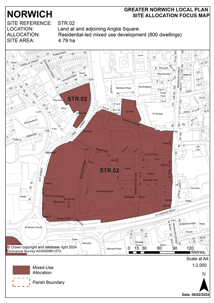
2.25 Anglia Square is a 1960s neighbourhood shopping precinct, forming the main part of the large district centre in the north of the city centre. This site is a major regeneration priority. The capacity of Anglia Square to deliver a significant element of the plan’s housing need on a highly accessible brownfield site means that it has strategic significance for Greater Norwich. The Employment, Town Centre and Retail Study (GVA, 2017) acknowledges the considerable potential of Anglia Square to accommodate a much-enhanced retail and leisure offer including extensive public realm improvements.
2.26 Development of the site must address a number of constraints including its location within the City Centre Conservation Area and the Area of Main Archaeological Interest, critical drainage catchment area, the relationship with neighbouring statutory and locally listed buildings, site ground conditions, its prominent location at gateways to the city, removal of the derelict and long-term vacant buildings from the site and transport infrastructure. A noise impact assessment and air quality assessment will be required, and the development must be designed to mitigate the impact of noise from the adjacent roads.
2.27 There are existing mains and foul and surface water sewers in Anglian Water’s ownership within the boundary of the site. This should be taken into account in the design of the development including safeguarding suitable access for maintenance.
2.28 Following the secretary of state’s refusal in November 2020 of a scheme that would have provided over 1,200 homes, the capacity of the site to accommodate housing will need to be considered in the context of the quantum of other uses to be provided as part of the development and taking into consideration the sensitivity of its location in the City Centre Conservation Area. It is a highly sustainable location where high densities are encouraged although the constraints of the site do limit its potential. The level of development and detailed design is best determined through the development management process informed by consideration of the factors listed in the policy below. The 800 homes figure in this policy is used in calculations of the contribution of the site to the ‘total housing potential’ of the strategy, and for interim monitoring, although this is neither an assessment of capacity nor a minimum requirement. Anglia Square should retain its position as part of a defined large district centre, complementing the city centre retail offer.
2.29 In April 2023, the site was granted hybrid (part full/part outline) planning permission for up to 1,100 dwellings and up to 8,000 square metres of flexible retail, commercial and other non-residential floorspace including a community hub. The permission also included up to 450 car parking spaces and associated works to the highway and public realm areas.
POLICY STR.02
Land at and adjoining Anglia Square, Norwich (4.79 hectares) is allocated for residential-led, mixed-use development as the focus for an enhanced and improved large district centre and to act as a catalyst for wider investment and redevelopment within the Northern City Centre strategic regeneration area as defined in policy 7.1 of this plan.
The site will deliver in the region of 800 homes taking into account the quantum of other uses that are proposed, its location within the City Centre Conservation Area, and scheme viability.
The development will achieve the following site-specific requirements:
- Delivery of a comprehensive, mixed use regeneration scheme which can include residential development, student accommodation, retail units contributing to the Magdalen Street/Anglia Square large district centre, offices and flexible workspace, hotel, leisure and hospitality uses and community facilities as part of a balanced mix to support the large district centre.
- Phasing (where appropriate) to be agreed.
- Significant improvements to the quality of the retail/leisure offer. The development should also provide an active frontage between Magdalen Street and St Augustine’s Street.
- Removal of the derelict and long-term vacant buildings from the site, including Sovereign House and the existing multi-storey car park.
- Provision of an appropriate level of car and cycle parking to serve the large district centre taking into consideration the highly sustainable location of the site and the proximity of alternative car parking provision off-site.
- Achievement of high-quality, locally distinctive and energy efficient design with scope for a landmark building or buildings providing a new focal point for the Northern City Centre and sited to conserve and enhance the significance of heritage assets and their settings.
- Heritage Impact Assessment (HIA) will be required to inform the capacity of the site and design of the proposed development alongside consideration of other constraints and viability. Development should conserve, and, where opportunities arise, enhance the City Centre Conservation Area and the settings of nearby listed buildings including those at Magdalen Street, Doughtys Hospital, St. Augustines Street (including grade I listed Church of St Augustine) and 2-12 Gildencroft.
- Heritage interpretation measures to be incorporated in accordance with policy 3 of this plan.
- The site is located within The Area of Main Archaeological Interest. An archaeological assessment will be required as part of a planning application.
- High-quality landscaping, planting and biodiversity enhancements.
- Low levels of residential car parking as part of a package of measures promoting sustainable travel and taking into consideration the highly accessible City Centre location of the site.
- A noise impact assessment and air quality assessment will be required, and the development must be designed to mitigate the impact of noise from the adjacent roads.
- Significant improvements in connectivity and permeability across the site to deliver new and enhanced pedestrian and cycle links north-south between Edward Street and St Crispin’s Road, and east-west between Magdalen Street and St Augustine’s and improved integration with the surrounding network.
- High-quality public realm improvements creating attractive, legible and user-friendly streets and public spaces both within the site and adjacent to it on Magdalen Street (including land under the flyover), Pitt Street and Edward Street.
- A mobility hub featuring shared transport services (buses, car club and bike share) centred on Magdalen Street in the vicinity of the flyover that is easily accessible on foot and by bicycle to promote use of sustainable transport modes by residents, visitors, and other users.
POLICY STR.03 Land known as ‘Site 4’ at Norwich Airport
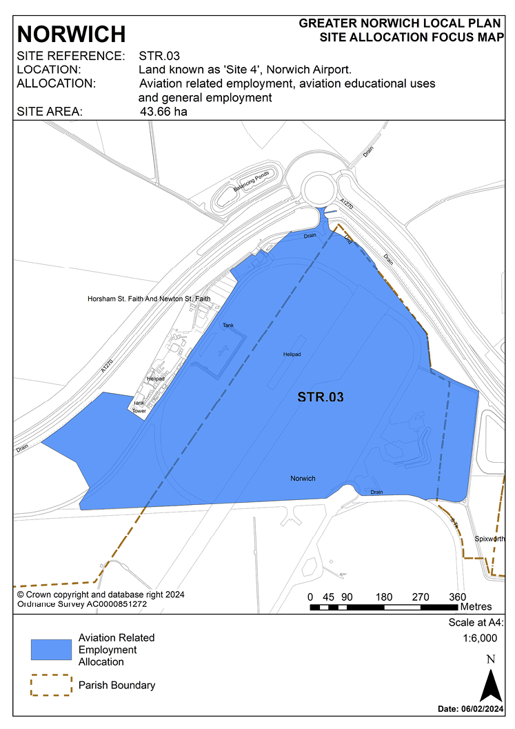
2.30 Norwich Airport is located on the northern edge of the city of Norwich and accessed from the A140 Norwich to Cromer Road. The passenger terminal and majority of associated commercial uses are sited towards the southern end of the airport. Site 4 is located at the northern end of the airport land, immediately to the south of the A1270 Broadland Northway.
2.31 There are residential and commercial/industrial uses on the land to the south-west, south and south-east, whilst the majority of the land to the north, beyond the Broadland Northway, is rural and agricultural, except for the villages of Horsham St. Faith and Spixworth which are in reasonably close proximity. Directly adjacent to the site on the north-west boundary is a series of linear buildings, structures and compounds that comprises a safety training facility (Petans) which is accessed from the north via Bullock Hill.
2.32 The site rises gently to the north. It is largely featureless with the land consisting of a taxiway and grassland within the operational boundary of the airport. The site is 43.66 hectares and of this 28.38 hectares is within Norwich’s administrative boundary and 15.28 hectares is within Broadland.
2.33 This site provides a unique opportunity as it is the only site that can provide development for aviation related uses. In accordance with the Norwich Airport Masterplan endorsed by both Norwich City Council and Broadland District Council, the site is allocated for aviation related employment, aviation educational uses and general employment with a cap on the amount of non-aviation uses. Following a significant period of marketing the site for aviation related uses with no success, the inclusion of non-aviation employment land may act as a catalyst to development of this site; further to this, securing non-aviation development on this site should provide a serviceable plot more likely to attract future aviation uses. It is important that in line with the masterplan a minimum of 20.5 hectares of the site is retained for aviation uses (which means that approximately 47% of the site will be safeguarded for aviation related employment and educational uses). This will ensure that there is sufficient land to attract additional large aviation-related businesses. These businesses could be lost to the local area if there is nowhere to suitably locate them.
2.34 Given the evidence set out within the Review of Office Accommodation in Norwich (Ramidus, 2020), it is not considered appropriate to allow non-aviation related office uses due to the potential harm that this could have on Norwich’s city centre and similarly it is not considered that retail and leisure uses would be appropriate in this out of centre location.
2.35 Access to the site should be from the A1270 and a surface access strategy will be required to promote sustainable travel to the site.
2.36 Preparation and approval of a surface access strategy is required prior to the occupation of more than 30,000 square metres (gross external area (GEA)) of floor space.
POLICY STR.03
Land known as ‘Site 4’ at Norwich Airport (43.66 hectares) is allocated for aviation related employment, aviation educational uses and general employment. Aviation related uses shall be those that fall within the following use classes: E(g)(ii) (the research and development of products and processes), E(g)(iii) (any industrial process), B2 (industrial), B8 (storage and distribution and F1(a) (for the provision of education). General employment shall be for those that fall within the use classes E(g)(ii) (the research and development of products and processes), E(g)(iii) (any industrial process), B2 (industrial) and B8 (storage and distribution).
The development will achieve the following site-specific requirements:
- Provide development of aviation related uses and general employment. Non-aviation development will be limited to no more than 23.16ha of the site and no more than 50% of the floorspace on the development. Non-aviation related office uses and retail and leisure uses will not be accepted.
- Development proposals shall only be approved where they adhere to the principles set out in a Design Concept Masterplan for the whole site which is approved by the Council. The Design Concept Masterplan shall include an indicative layout (clearly identifying areas for aviation and non-aviation uses), a phasing plan, and information on the delivery of critical infrastructure, landscaping, ecology, drainage and sustainable transport measures.
- Prior to the occupation of more than 30,000 square metres (GEA) floor space, an Airport Surface Access Strategy for the wider airport operational area, which promotes sustainable transport to the site, shall be approved by the Council and prior to the occupation of development of any phase (as agreed through the Design Concept Masterplan) an Interim Travel Plan for that phase shall be approved.
- Provision of a mobility hub on the site to allow for bus drop off/pick up, turnaround space, passenger waiting facilities, electric vehicle charging points, car club vehicle(s) and cycle provision/parking.
- Prior to the occupation of more than 30,000 square metres (GEA) floor space a scheme for the provision of a bus link and bus gate between the terminal building and Spitfire Road shall be approved by the Council. There is limited scope to provide enhanced facilities for non-car modes of access to the site so this can be mitigated by offsetting against the rest of the airport where sustainable access enhancements can be more readily achieved.
- Provide vehicular access from the existing roundabout at Broadland Northway (A1270).
- Demonstrate that appropriate account has been taken of the potential impacts of noise from existing and proposed airport operations and noise generation from the development itself.
- Be subject to landscape visual impact assessment and appropriate landscape mitigation to the north-west, north and north-east boundaries. SUDs will need to be provided as part of the development.
- Changes of use will normally be restricted by conditions on any future planning approvals to prevent units being utilised more broadly, and where aviation related uses have been granted, to prevent the change to non-aviation related uses and to set a limit on the amount of ancillary trade counters, display and office use.
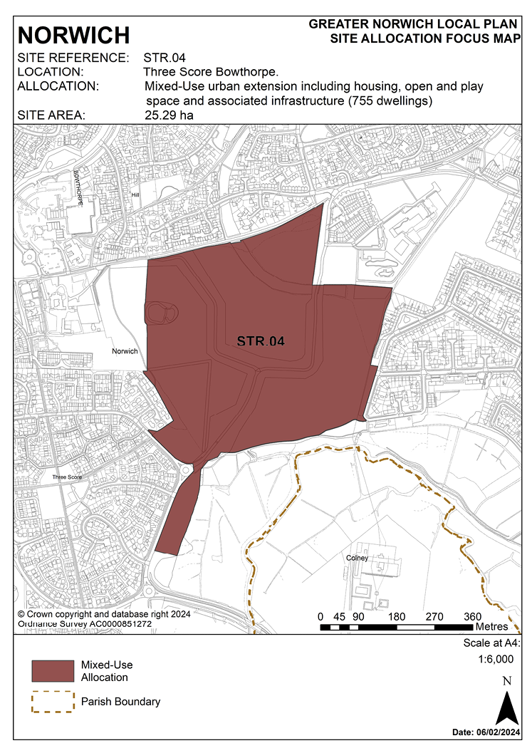
POLICY STR.04 Three Score, Bowthorpe, Norwich
2.37 The site was allocated in the previous local plan for residential-led mixed-use development and is being developed in accordance with an approved masterplan. The site benefits from extant planning permission. Outline planning permission was granted on 8 July 2013 for 1,000 homes and a care home (12/00703/O). Condition 11 requires the approval of all reserved matters within fifteen years from the date of the permission.
2.38 Phase 1, which was for 92 housing with care units and an 80 bed dementia care home, is fully complete (13/02031/RM). This was completed before the GNLP plan period, as such it is not counted in the numbers for the GNLP. Reserved matters were originally approved for phase 2 for 172 dwellings, but the number of units was reduced to 153 by a Minor Material Amendment application (19/0497/MA). This phase is nearing completion. These two phases are not included in the GNLP site allocation and together provide for 245 of the 1,000 homes permitted under the outline consent.
2.39 This leaves 755 homes to be provided on the remainder of the site. A reserved matters application was approved on 21 October 2021 for 76 dwellings and associated works on part of the site that is to be allocated under the GNLP (21/01073/RM). It is anticipated that other reserved matters applications will come forward in due course and within the time period required by condition 11 of the outline consent. Development of the rest of Three Score is expected to take place within the time-period of this local plan.
2.40 The site is re-allocated for residential-led mixed use development including open space. The site is likely to accommodate in the region of 755 homes.
POLICY STR.04
Three Score, Bowthorpe, Norwich (25.29 hectares) is allocated for an urban extension including housing, open and play space and associated infrastructure. This will accommodate in the region of 755 homes.
The development will achieve the following site-specific requirements:
- Be planned as an exemplar development with a distinct character and identity, providing for exceptionally high standards of design, energy efficiency and flood resilience (including addressing identified risks from flooding from rivers and surface water flooding).
- Provide permeability through the site including connections to the existing strategic cycle network, new bus routes and a network of attractive and walkable pedestrian routes providing for safe and convenient movement within and between existing and proposed housing areas, the Bowthorpe district centre, the new village centre and the Yare valley and open countryside beyond.
- Make provision for significant areas of recreational and informal open space, play space, green infrastructure (including retained woodland) and enhance ecological networks to support biodiversity and geodiversity.
- Respect the character and distinctiveness of the surrounding area, to improve the setting of Bowthorpe Hall and the surrounding conservation area, preserve the open character of the Yare valley and distinctive landscape of the valley edge, and maintain strategic long views through and beyond the development area.
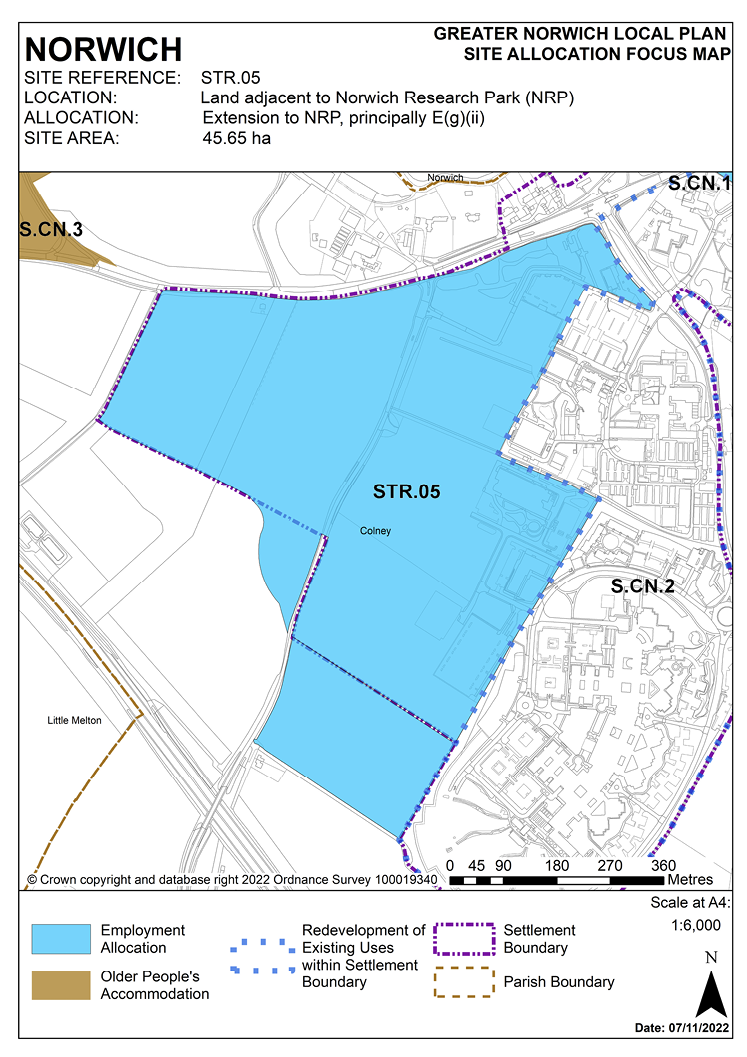
POLICY STR.05 Land adjacent to Norwich Research Park (NRP), Colney
2.41 The site was allocated in 2015 as part of the South Norfolk Local Plan. Science Park and hospital related uses remain appropriate, and COL 1 is re-allocated as a strategic employment allocation.
2.42 Norfolk Minerals and Waste Core Strategy CS16 applies, as this site is underlain by safeguarded minerals resources. The benefits of extracting the minerals, if feasible, will be taken into consideration.
2.43 The Historic Environment Record is to be consulted to determine any need for archaeological surveys prior to development.
POLICY STR.05
Land adjacent to Norwich Research Park (NRP), Colney (45.65 hectares) is allocated principally for an E (gii) Science Park development, hospital expansion and other proposals ancillary and complementary to these main uses.
The development will achieve the following site-specific requirements:
Uses
- Acceptable uses will be research and development use under Class E (gii) ‘research and development’ of the Town and Country Planning (Use Classes) Order 2020 (as amended) plus hospital and hospital related uses. Other uses clearly ancillary to the main functions of the Norwich Research Park (NRP) and/or complementary to the main anchor institutions will also be acceptable.
- Planning conditions will be applied to consents granted under Class E(g)(ii) to prevent changes of use within Class E in order to protect the function of the Research Park and to restrict the proliferation of town centre uses in out of centre locations.
Master plan/infrastructure plan
- Proposals within this site allocation boundary should have regard to the existing approved illustrative masterplan or any subsequent approved revision and include phasing in relation to the delivery of infrastructure, provision of high-quality buildings and spaces; and a landscape strategy and green infrastructure plan.
- Any revised masterplan for the allocation should be supported by a utilities/infrastructure plan which will include the necessary transport improvements detailed below.
Development will be expected to address the following specific matters:
Transport
Measures which address the impacts of the proposed development, including where appropriate:
- Improvements to the B1108 Watton Road junctions which access the NRP.
- Improvements to the capacity at the B1108/A47 junction, to ensure that it does not become a constraint to development.
- Maintaining and enhancing safe and convenient access to the Norfolk and Norwich University Hospital.
- Public transport access and provision, to encourage significant modal shift to/from and within the wider NRP, including measures identified through the Transport for Norwich programme.
- Safe and convenient pedestrian and cycle links within the wider NRP and to/from significant areas of housing (specifically at Cringleford, Hethersett and Threescore/Bowthorpe), including completion of the Hethersett to NRP cycleway.
- Parking ratios of approximately 1 space per 60m2 of floor area (excluding plant).
- The developer should ensure that sufficient land is made available to deliver the required infrastructure.
Design and Landscape
- Landmark design quality, including a safe and attractive public realm, creating an integrated approach to existing and new development at the NRP.
- Development contributes positively to green infrastructure and the landscape setting including retention of the existing shelter belts, hedgerows and significant trees and linking of features to the wider landscape.
- Development density to reflect the transport constraints of the locality and the aspirations for design quality and landscaping.
- Any development must conserve and, where opportunities arise, enhance the significance of the Old Hall and its wall and the Rectory, including any contribution made to that significance by setting. This includes but is not limited to appropriate landscaping, density, and design.
Constraints
- Site-specific flood risk assessments.
- Layout to take account of water main and sewers crossing the site.
- An archaeological assessment will be required prior to development.
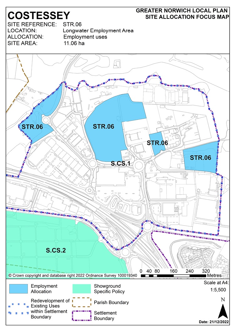
POLICY STR.06 Longwater Employment Area, Costessey
2.44 This site was allocated in the 2015 South Norfolk Local Plan and employment uses in this location remain appropriate. The site is re-allocated with additional land promoted which will be incorporated within the settlement boundary.
2.45 Norfolk Minerals and Waste Core Strategy Policy CS16 applies, as this site is underlain by safeguarded minerals resources and is within a minerals and waste consultation area. The benefits of extracting the minerals, if feasible, will be taken into consideration and developers will need to consult Norfolk County Council (Minerals and Waste) as part of any future applications on the site.
POLICY STR.06
Longwater Employment Area, Costessey (11.06 hectares) is allocated for employment uses.
The development will achieve the following site-specific requirements:
Uses
- Principally for E(g), B2 and B8 use class (2020) employment uses.
- Other employment uses that are not identified as main town centre uses in the National Planning Policy Framework, specifically further car showrooms and petrol filling stations.
Transport
- Appropriate and proportionate contributions to short, medium and long-term improvements to the A47 Longwater Junction to ensure that capacity does not become a constraint on development.
- Proportionate contributions to public transport improvements on the Dereham Road corridor and other public transport enhancements in accordance with the latest version of the Transport for Norwich implementation plan.
- Safe and convenient pedestrian and cycle links to key locations including access to Longwater retail and nearby residential locations at Queen’s Hill, New Costessey and Easton.
Constraints
- Protection of Long Dale County Wildlife Site to the north of the employment area.
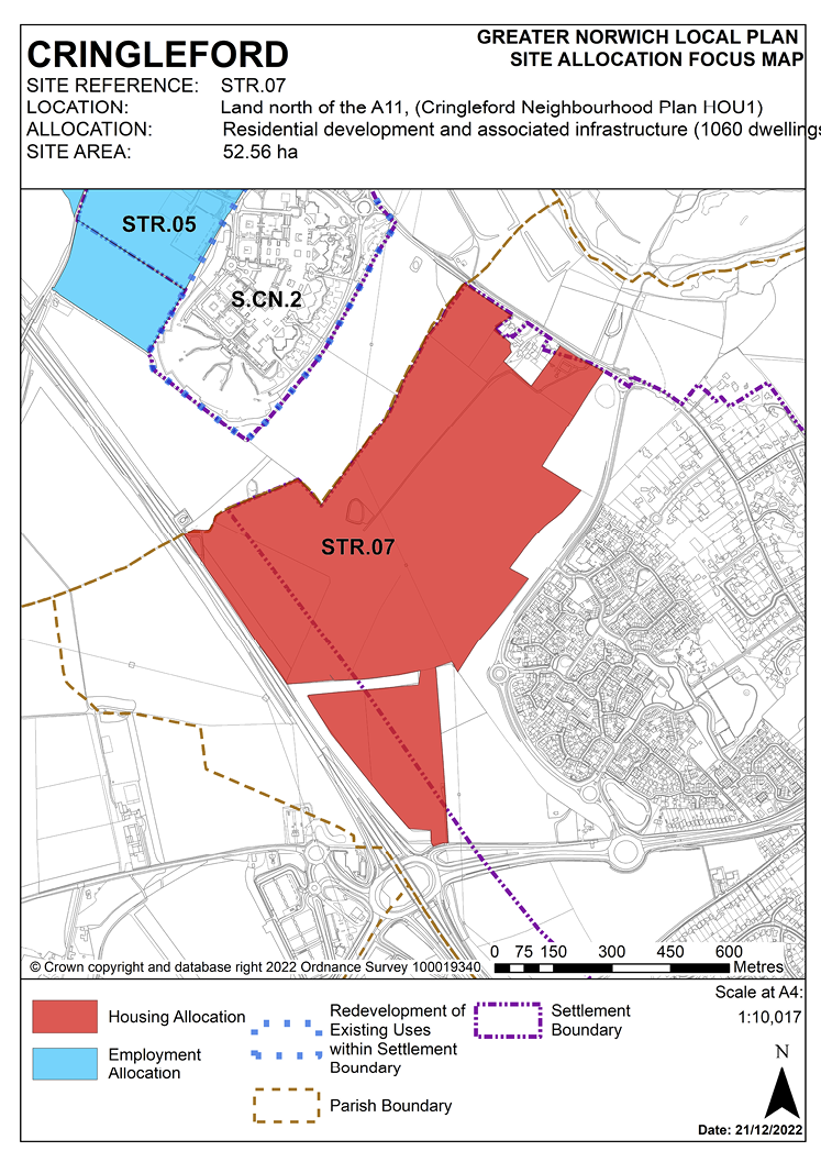
POLICY STR.07 Land north of the A11, Cringleford
2.46 The Cringleford Neighbourhood Plan identified an area for approximately 1,200 new homes for which permissions are now in place (outline application references 2013/1494 and 2013/1793) for up to 1,300.
2.47 These permissions do not occupy the whole of the housing site allocation in the Neighbourhood Plan. The remaining area of land identified in the Neighbourhood Plan as suitable for development is located between the Norwich Southern Bypass Landscape Protection Zone (set out in the Neighbourhood Plan) and the edge of the permitted schemes giving potential for further development beyond 2026. Both outline permissions make provision for a primary school site, but only that within outline 2013/1793 will be required. The primary school site within outline permission 2013/1793 is approximately 2 hectares, the identified housing uplift is likely to require a larger school site, to be accommodated on land adjoining the already identified site.
2.48 Part of the site is adjacent to a stream with a significant section of culverted watercourse (1.2km) in total. Opening up this stream again as well as any contribution towards enhancing the natural habitats of the Yare Valley would be supported by the Environment Agency.
2.49 Highways England has confirmed that it is likely that the proposed improvement of the A47 Thickthorn interchange will be able to accommodate the proposed uplift but this will need to be confirmed with a transport assessment.
2.50 The Historic Environment Record is to be consulted to determine any need for archaeological surveys prior to development.
2.51 Norfolk Minerals and Waste Core Strategy Policy CS16 applies, as this site is partly underlain by safeguarded minerals resources. The benefits of extracting the minerals, if feasible, will be taken into consideration.
POLICY STR.07
(Part of Cringleford Neighbourhood Plan HOU1) Land north of the A11 (52.56 hectares) is allocated for residential development and associated infrastructure. This will accommodate approximately 1,060 homes.
The development will achieve the following site-specific requirements:
- Development to comply with the policies of the Cringleford Neighbourhood Plan 2013-2026, including that no more than approximately 1,300 homes are built prior to 2026.
- A transport assessment will be required, to include:
- Confirmation that the proposed improvements to the A47 Thickthorn Interchange can accommodate the uplift in dwelling numbers.
- Connections to adjacent sites by all modes which support active travel where feasible.
- Footpath and cycleway connections to the Roundhouse Way bus interchange.
- Improvements to Colney Lane.
- Enhanced pedestrian, cycle and public transport access to the wider Norwich Research Park (including the UEA).
- Enhanced walking routes to nearby schools.
- Approximately 3 hectares of the site should be safeguarded for a new school, or equivalent alternative provision in agreement with the education authority.
- Adequate green infrastructure and a landscape buffer will be provided outside the settlement limit in accordance with the bypass protection zone adjacent to the A47 including adequate noise mitigation measures to protect residential amenity.
- Pollution control techniques to ensure that development does not lead to pollution of the water environment as the site falls within source protection zone 3.
- An archaeological assessment will be required prior to development.
- Provision of a drainage system (SUDs).
- Mitigation to address utilities infrastructure crossing the site.
POLICY STR.08 Land south and east of Easton
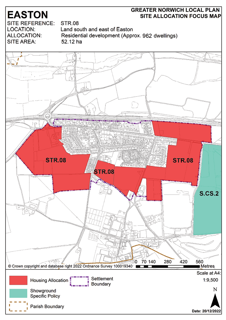
2.52 The site was allocated in 2015 as part of the South Norfolk Local Plan. The principle of development on the site has already been accepted and it is expected that development will take place within the time-period of this local plan up to 2038. The site has outline planning permission for 890 units, with reserved matters consented on one part of the site where construction has commenced, and two further reserved matters applications pending determination. There is a separate full consent for a development of 72 homes on the parcel of land North of Dereham Road. In addition to this the parcel of allocated land to the east of Easton Gymnastics Club has consent for erection of a new Special Educational Needs and Disabilities (SEND) school. The site is therefore re-allocated for residential development for a total of 962 units. It is recognised that a number of the policy requirements will have already been met through the planning consent on the site.
2.53 Norfolk Minerals and Waste Core Strategy Policy CS16 applies, as this site is underlain by safeguarded minerals resources. The benefits of extracting the minerals, if feasible, will be taken into consideration.
POLICY STR.08
Land south and east of Easton (52.12 hectares) is allocated for residential development and associated infrastructure. This will accommodate approximately 962 homes.
The development will achieve the following site-specific requirements:
Master Plan
A comprehensive masterplan to cover the provision of social and green infrastructure and highways improvements, taking into account the other requirements of this policy, and address:
- Phasing which clearly identifies when key infrastructure will be provided in relation to the provision of new housing. Phasing should be designed to ensure development minimises the disturbance to existing residents.
- The relationship to any continued expansion of Easton College and the Norfolk Showground (including the loss of any land currently used for showground parking).
- The approach to densities across the allocation, including higher densities close to the proposed village centre.
- Careful consideration of development west of the existing allotments, including the retention of this area as open space.
- A local centre at the heart of the development, easily accessible to surrounding residential areas.
Enhanced Facilities
- Provision of a new village centre in the vicinity of the indicative site shown on the Easton Inset Map, to include a new village hall, village green/focal recreation space, shared parking provision with primary school.
- Expanded primary school provision in agreement with the education authority.
Heritage Assets
- Application to be accompanied by an assessment of the significance of St Peter’s Church as a heritage asset, the extent of its setting and the contribution that its setting makes to its significance.
- Any development must conserve and, where opportunities arise, enhance the significance of the grade I listed Church of St Peter including any contribution made to that significance by setting. This includes, but is not limited to, ensuring that sufficient open space and landscaping is retained to the south, south-east and south-west of St Peter’s Church and that sufficient planting is provided, such that its setting, and the wooded setting of Diocesan House and the Vicarage, are protected.
Landscaping and Green Infrastructure
- Protection of the existing allotments and any other sites in community use, or relocation to an equivalent or better site.
- Provision of a landscape buffer and enhancements to the A47 corridor – layout and landscaping should take into account both visual enhancement and the noise implications of the neighbouring A47 and Showground and include any proposals for acoustic barriers.
- Identification and protection of significant biodiversity features including trees and hedgerows, incorporated within open space and with off-site mitigation where on-site protection cannot be achieved.
- Green infrastructure enhancements, including the approach to the area between the village and Easton College.
- Proportionate contributions to the access improvements to the Yare Valley and Bawburgh/Colney Lakes.
Transport
Highways and transport improvements as agreed, to include:
- Proportionate contributions to short, medium and long-term improvements to the A47 Easton and Longwater junctions to ensure that junction capacity does not become a constraint on development.
- Provision of new vehicular accesses for development to the south of the village, to supplement Marlingford Road and Bawburgh Road.
- Provision for, and proportionate contributions to, Dereham Road Bus Rapid Transit (BRT), including improved access to facilities in Costessey, and other public transport enhancements in accordance with the latest version of the Norwich Area Transportation Strategy (NATS)/Transport for Norwich Strategy implementation plan.
- Safe and convenient pedestrian and cycle links to key locations, including Longwater employment and retail, Costessey Medical Centre, Ormiston Victory Academy, Costessey Park and Ride site and Easton College.
Site conditions and constraints
- Investigation of ground conditions at the former gravel pit north of Dereham Road.
- Site layout to take account of water mains and sewers crossing site.
POLICY STR.09
Land at the Royal Norwich Golf Club, either side of Drayton High Road, Hellesdon
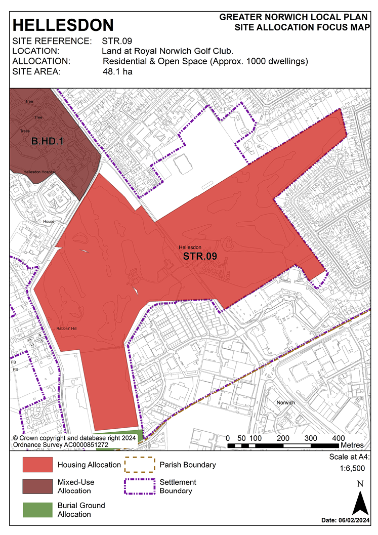
2.54 This site was allocated in 2016 as part of the Broadland Local Plan. Outline planning consent has been obtained for the whole of this allocation, detailed consent has been obtained for phases 1 and 2 which are under construction, and an application for phase 3 has been submitted. It is expected that the complete development will take place within the time-period of the new local plan up to 2038. The site is re-allocated for residential development.
2.55 Norfolk Minerals and Waste Core Strategy Policy CS16 applies, as this site is underlain by safeguarded minerals resources. The benefits of extracting the minerals, if feasible, will be taken into consideration.
POLICY STR.09
Land at the Royal Norwich Golf Club, either side of Drayton High Road, Hellesdon (48.1 hectares) is allocated for residential and open space uses. This will accommodate approximately 1,000 homes.
The development will achieve the following site-specific requirements:
- Improvements may be needed to existing traffic light-controlled junction and a possible pedestrian crossing on the A1067 Drayton High Road.
- Up to 2 hectares of the site should be safeguarded for education provision, either as an expansion of the existing schools (Kinsale Infant School, Kinsale Junior School and Hellesdon High School) or land for a new primary school elsewhere within the site.
- The loss of the golf course should be mitigated by providing alternative equivalent provision elsewhere.
- The south-west corner of the site is within the HSE safeguarding zone associated with the chemical plant to the south of the site.
- The site falls within Source Protection Zone 3 and therefore pollution control techniques should be incorporated to ensure that development of the site does not lead to pollution of the water environment.
POLICY STR.10
Land off Blue Boar Lane/Salhouse Road, White House Farm, Sprowston
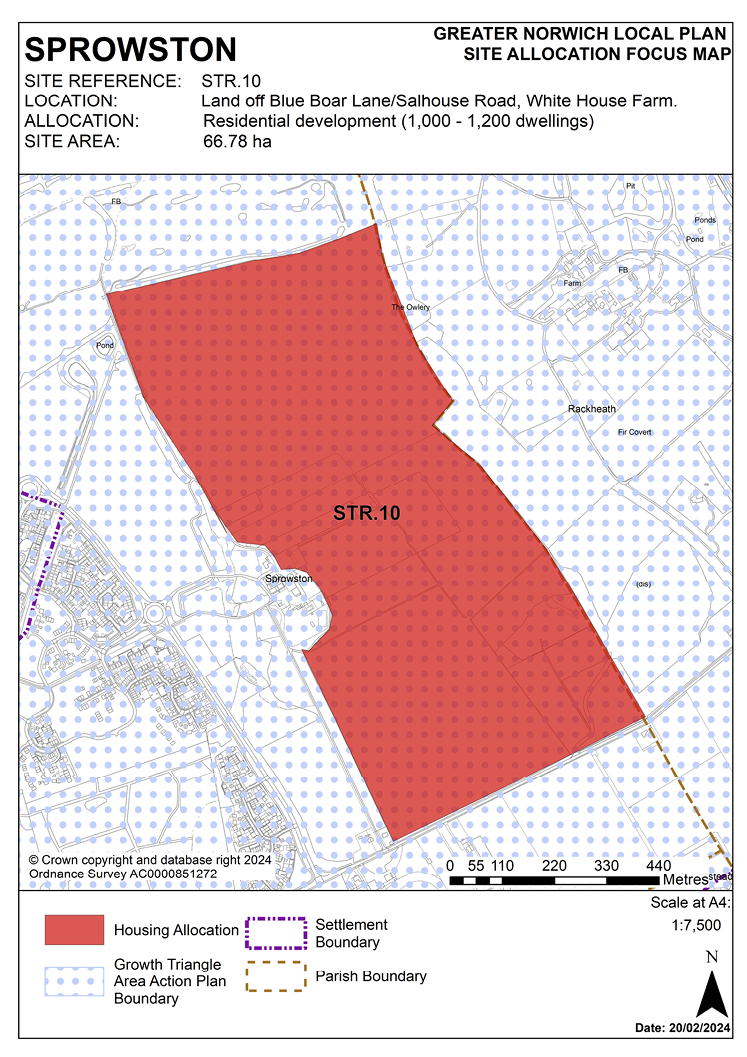
2.56 This is a large strategic scale greenfield site off Salhouse Road adjacent to a major existing allocation within the North-East Growth Triangle AAP. ;There are no major constraints to make the site unsuitable for development, therefore the site is allocated subject to an acceptable masterplan incorporating the requirements set out in the policy below.
2.57 Norfolk Minerals and Waste Core Strategy Policy CS16 applies, as this site is partly underlain by safeguarded minerals resources. The benefits of extracting the minerals, if feasible, will be taken into consideration.
POLICY STR.10
Land off Blue Boar Lane/Salhouse Road, White House Farm, Sprowston. An area of 66.78 hectares is allocated for residential development. The site is expected ;to accommodate approximately 1,000 – 1,200 homes, open space and, if required, land for a new high school.
Should land for a secondary school be required the land uses shall comprise:
- At least 1,000 dwellings.
- 12 hectares of land for a secondary school with sports pitches to be made available for community use.
- Informal open space, children’s play space, and allotments in accordance with the policies of the adopted development plan.
Should land for a secondary school not be required the land uses shall comprise:
- At least 1,200 dwellings.
- 2 hectares of land for a primary school.
- Formal and informal open space, including sports pitches, in accordance with the policies of the adopted development plan.
The arrangement and interrelationship of different land uses resulting from the development of the site will be established through a participative masterplanning process. The development of the site will be in accordance with the resulting masterplan, which shall be submitted as part of the planning application for the site.The masterplan should clearly demonstrate how the development has been designed to respond to the particular characteristics of the site and to interact and function appropriately with adjacent development sites. The masterplan should demonstrate how homes, jobs, services, and facilities have been integrated with walking and cycling, public transport facilities/services, provision for private vehicles and green infrastructure.
Development will not be commenced until a phasing plan indicating the orderly sequence of development has been approved. The phasing plan will need to show how infrastructure (including green infrastructure) and services are to be co-ordinated with the development of the site.
The masterplan should include:
- Vehicular, pedestrian and cycle access to the site via Salhouse Road and Atlantic Avenue. ;
- A new link road from Salhouse Road to Atlantic Avenue which includes footway and cycleway provision.
- The provision of a footway and cycleway along the southern boundary of the site adjacent to Salhouse Road, continuing provision delivered through the development of adjacent land.
- Off-site improvements to the highway network as necessary to address the impact of development.
- Up to 12 hectares of the site should be safeguarded to incorporate a well-located high school. An off-site drop-off area for buses and coaches to serve the school should be incorporated as part of the highway infrastructure for the development. Community use of open space associated with the school should be facilitated.
- Appropriate protection of, and mitigation for, impact on trees and woodland (established through an Arboricultural Impact Assessment). This should include safeguarding the ancient woodland of Bulmer Coppice and historic Rackheath parkland to the east of the site.
- The delivery of green infrastructure to ensure connections between Harrisons Woodland Park and Bulmer Coppice/Rackheath Park.
- An ecological assessment will be required to show how impacts on ecology, including great crested newts, have been minimised and mitigated as part of the development of the site.
- Appropriate remediation of any land contamination and/or localised made ground deposits, including those related to an historic gravel pit and landfill to the east of the site.
- This site intersects watercourses so a Water Framework Directive compliance assessment will be required for the watercourse receiving the runoff. A buffer of 20 metres will need to be maintained between the watercourse and gardens and opportunities for riparian habitat restoration should be secured.
The Requirement for a Secondary School
The secondary school site will be safeguarded from development until 1 April 2026 or such time as a planning application including land for the secondary school at Rackheath on site GT16 is approved and land for the secondary school is secured through a planning obligation, or such time as a formal notification is received from the local education authority that the secondary school is not required, whichever is sooner.
If notification is received from the local education authority on or prior to 1 April 2026 that the secondary school is required, then the site will be transferred to the local education authority in accordance with an infrastructure phasing plan to be agreed with the local planning authority prior to the grant of planning permission. The notification from the local education authority will include a commitment and timescale for the purchase of the secondary school land.
POLICY STR.11
Land between Fir Covert Road and Reepham Road, Taverham
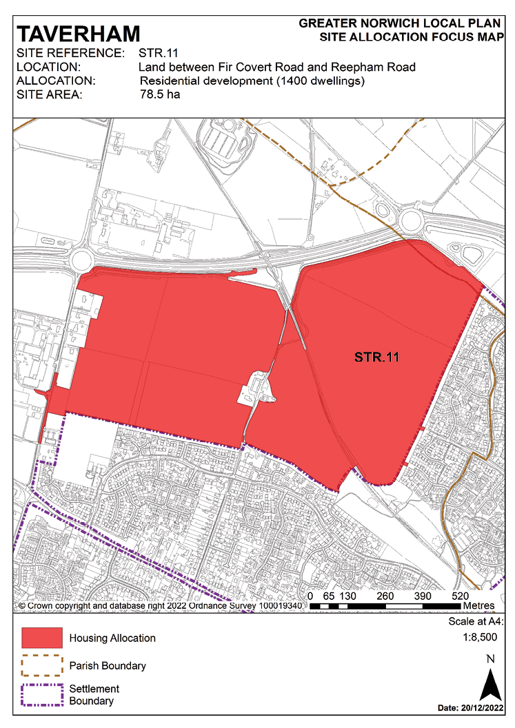
2.58 This is a strategic-scale site well-related to the existing edge of Thorpe Marriott with no major constraints to make the site unsuitable for development. Highway improvements will be needed including provision of roundabout access at Fir Covert Road, priority access at Reepham Road and traffic signals at the A1067 Fakenham Road/Fir Covert Road.
2.59 The site will need to be masterplanned to provide a local centre consisting of a small group of shops, services and/or amenities to promote placemaking and meet the day to day needs of residents. A supermarket has recently opened on the opposite side of Fir Covert Road, as such the local centre is not expected to include facilities already provided. The masterplan should also provide detail of community and recreation facilities including a school and medical care facility.
2.60 Norfolk Minerals and Waste Core Strategy Policy CS16 applies, as this site is underlain by safeguarded minerals resources. The benefits of extracting the minerals, if feasible, will be taken into consideration.
POLICY STR.11
Land between Fir Covert Road and Reepham Road, Taverham (78.5 hectares) is allocated for residential development. ; The site will accommodate approximately 1,400 homes including specialist care housing and older persons housing units, associated public open space, and a local centre, primary school and local medical centre.
The development will achieve the following site-specific requirements:
- Preparation of a masterplan to guide the development of the whole site, submitted as part of the first application for planning permission.
- Provision of on-site recreation to encourage healthy lifestyles, in accordance with relevant policies.
- 2 hectares safeguarded for provision of a primary school.
- Land safeguarded for provision of a medical care facility.
- A local centre at the heart of the development, easily accessible to surrounding residential areas. The local centre should consist of a small group of shops or services and amenities to enhance placemaking and vitality of the development, and to ensure residents have access to services which provide for day-to-day needs.
The masterplan should demonstrate:
- Detailed arrangements for access (vehicular and pedestrian) such as from Reepham Road and Fir Covert Road, pedestrian/cycle links at Felsham Way, Ganners Hill, Breck Farm Lane, and Kingswood Avenue.
- The distribution of land uses across the site. The school and medical care facility should be centrally located on the site. ;
- Off-site improvements to the highway network which may include provision of a new roundabout on Reepham Road, and Fir Covert Road including a proposed link road.
- No adverse effect on the operation of the water treatment works.
- Safeguarding landscape enhancements and a buffer to the Marriott’s Way.
- The approach to phasing of development across the site.
- Provision of an appropriate landscape buffer adjacent to the A1270 and adequate noise mitigation measures to protect residential amenity.
- Inclusion of pollution control techniques to ensure that development does not lead to pollution of the water environment as the site falls within source protection zone 3.
- Submission of an Arboricultural Impact Assessment (AIA) to protect or to mitigate any harm to trees on-site.
- Submission of an ecological assessment to identify key ecological networks and habitats to be preserved and enhanced through the development.
- Mitigation of surface water flooding on-site.
- The approach to infrastructure delivery on and off-site.
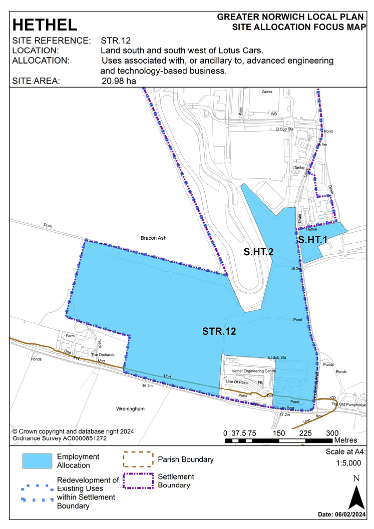
POLICY STR.12
Land south and south-west of Lotus Cars, Hethel
2.61 This site was allocated in the South Norfolk Local Plan but has not yet been developed. Nevertheless, this is a key strategic employment location for Greater Norwich. Interest in development remains high and it is expected that development can come forward within the new local plan time-period up to 2038.
2.62 The Norfolk Historic Environment Service is to be consulted to determine any need to archaeological surveys prior to development.
2.63 Norfolk Minerals and Waste Core Strategy Policy CS16 applies as this site is within a minerals and waste consultation area. Developers will need to consult Norfolk County Council (Minerals and Waste Policy) as part of any future application on the site.
POLICY STR.12
Land south and south-west of Lotus Cars, Hethel (20.98 hectares) is allocated for uses associated with, or ancillary to, advanced engineering and technology-based business.
The development will achieve the following site-specific requirements:
- A masterplan for the whole site to be submitted with, or in advance of, the first application for planning permission. The site is to be planned in a way that would enable access to adjacent land for future development if required. Ancillary uses may be permitted to serve the allocation and surrounding employment uses.
- Suitable and safe access.
- Layout and landscaping to protect the residential amenity of nearby White Gables Farm.
- Improved accessibility and cycleway links to Wymondham.
- Improvements to the local footpath network.
- An archaeological assessment will be required prior to development.
- As part of the site is within a Hazardous Installation Consultation Zone the level of public risk will need to be assessed by the council in consultation with the Environment Agency and the Health and Safety Executive.
- A water main crossing the site may affect the final layout.
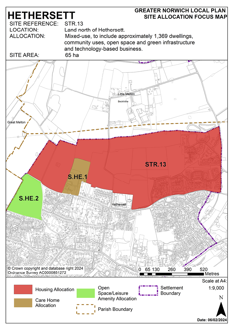
POLICY STR.13
Land north of Hethersett
2.64 The site lies to the north of the Poppyfields development, the plant nursery on Grove Road, Longview, the village hall and Back Lane, and south of Beckhithe Meadow County Wildlife Site (CWS), Holly Tree Farm and south-west of Braymeadow CWS. The allocation has an outline permission (2011/1804) which is under construction. Within the scope of the outline application, intensification has been possible and there is now scope to ‘uplift’ this previous allocation by 200 additional dwellings. There is no specific site within the larger allocation, so this uplift is applied to the entire site. Due to the size of the original allocation, a range of supporting infrastructure and facilities is required, and the following policy applies to the additional 200 dwellings, wherever they may be located within the site. Approximately 65 hectares is therefore allocated for mixed-use development, to include housing, community uses, open space, and green infrastructure. This will include approximately 1,369 dwellings.
2.65 The Historic Environment Record is to be consulted to determine any need for archaeological surveys prior to development.
2.66 Norfolk Minerals and Waste Core Strategy Policy CS16 applies, as this site is underlain by safeguarded mineral resources. The benefits of extracting the minerals, if feasible, will be taken into consideration.
POLICY STR.13
Land north of Hethersett (65 hectares) is allocated for mixed use, to include approximately 1,369 dwellings, community uses, open space and green infrastructure.
Proposals for the undeveloped parts of the site will need to be wholly consistent with the policy requirements set out below:
Masterplan and Phasing Plan
- A comprehensive approach to development must include provision of social and green infrastructure and highway improvements.
- A phasing plan is required which clearly identifies when key infrastructure will be provided in relation to the provision of new housing. Phasing should be designed to ensure development minimises the disturbance to existing residents.
Enhanced Facilities
- Community facilities, such as formal open space and/or buildings dedicated to community uses, will need to be included within the overall development in accordance with the most up-to-date needs assessment.
- Expansion of local schools or provision of land for additional school/s will need to be agreed with the education authority.
- Development of the site may require financial contributions to fund improvements to the surrounding road network in addition to any Thickthorn junction improvements. An assessment of the surrounding road network will be required to determine any financial contributions required to fund approvements.
Landscaping and Green Infrastructure
- The layout and landscaping of the final scheme must minimise the visual impact on the strategic gap between Hethersett and neighbouring settlements.
- Design should respond to the layout of earlier settlement patterns around commons and greens or other focal points.
- The design of the scheme must integrate landscape, open space and footpaths with the existing settlement.
- Design must maximise the benefit of green infrastructure provision and avoid adverse impact on designated sites, linking ponds, water courses and hedgerows.
- The landscape buffer to the north should provide green infrastructure links between Beckhithe Meadow and Braymeadow County Wildlife Sites and incorporate existing woodland and hedgerow features across the site.
Transport
- A transport assessment must consider the capacity of the improved A47 Thickthorn Interchange.
- A transport statement is required and the implementation of any approved measures.
- Vehicular access onto Colney Lane will be required.
- Footpath and cycle routes to Norwich Research Park and Little Melton will be required, and additional public rights of way to increase access to the countryside.
- Design of scheme must minimise impact on existing roads in the village by limiting the amount of additional traffic accessing the local road network.
Site Conditions and Constraints
- Site layout must account for high voltage power lines to the north of the site, which will need a suitable separation buffer. Other factors affecting the final layout include an oil pipeline crossing north-eastern corner of the site, water mains and sewers crossing the site, and the need for a buffer zone around sewage pumping stations.
- An archaeological assessment will be required prior to development.
- Mitigation and further investigation will be required with regard to site susceptibility to surface water flooding.
- Development should avoid contamination of groundwater.
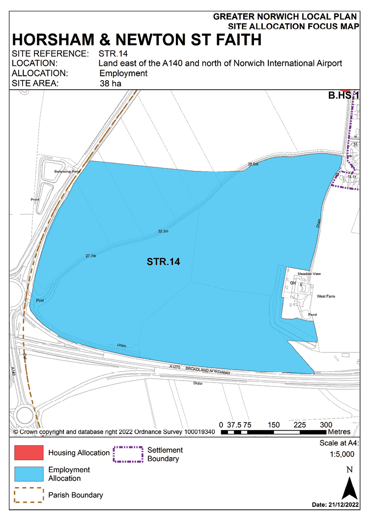
POLICY STR.14
Land east of the A140 and north of Norwich Airport, Horsham St Faith
2.67 This site to the east of the A140 and north of Norwich Airport was allocated in the 2016 Broadland Local Plan but has yet to be developed. The principle of development on the site has already been accepted and it is expected that development will take place within the new local plan time-period up to 2038. The site is allocated for a full range of employment/commercial development, including those benefitting from a location close to the airport.
2.68 Norfolk Minerals and Waste Core Strategy Policy CS16 applies, as this site is underlain by safeguarded minerals resources. The benefits of extracting the minerals, if feasible, will be taken into consideration.
POLICY STR.14
Land east of the A140 and north of Norwich Airport, Horsham St Faith (38 hectares) is allocated for employment uses. This will be to provide a full range of employment uses including for those benefitting from a location close to the airport.
It is expected that:
- Uses will be within use classes E(g), B2 and B8, with a maximum of 50% of total floorspace to be within the E(g)(i) use class.
- Substantial tree belts and landscaping will be provided at the boundaries of the site, with particularly extensive provision made at the northern and eastern boundaries to provide a buffer to residential properties. Civil Aviation Authority guidance should be followed to ensure aviation hazards posed by wildlife are minimised.
- Access will be provided directly from the A140/A1270 Broadland Northway interchange.
- A masterplan will be produced for the site with or in advance of the first application for planning permission showing a coordinated approach to bringing forward the development, particularly in relation to access provision including coordination with the Broadland Northway, any necessary off-site highway improvements, and the early provision of landscaping to mitigate visual impacts. Accordingly, development is to be in two phases: Phase 1, the south-western, north-western, and north-eastern parts of the site; Phase 2, the south-eastern portion.
The development will be expected to address the following specific matters:
- In order to achieve a range of employment uses (E(g) Business – offices, research and development, and light industry, B2 general industrial, B8 storage or distribution) and limit traffic generation, it is envisaged that the amount of floorspace in the E(g)(i) use class will not exceed 50% of the total floorspace within the overall development.
- Phase 1, the major part (29.6 hectares), will reflect the provision of access being from the west, and the need to provide tree belts and landscaping to the northern and eastern boundaries in the early stages.
- Phase 2 (5.2 hectares) is expected to progress in the later stages of development as needed and related to the provision of infrastructure.
- A transport assessment/statement will be required that will include assessments of highway infrastructure improvements to enable safe active and sustainable travel to the development. Any approved measures shall be implemented.
- The appropriate pollution control techniques should be installed to ensure that no harm comes to the water environment.
- An archaeological investigation must be undertaken prior to any development.
