6.75
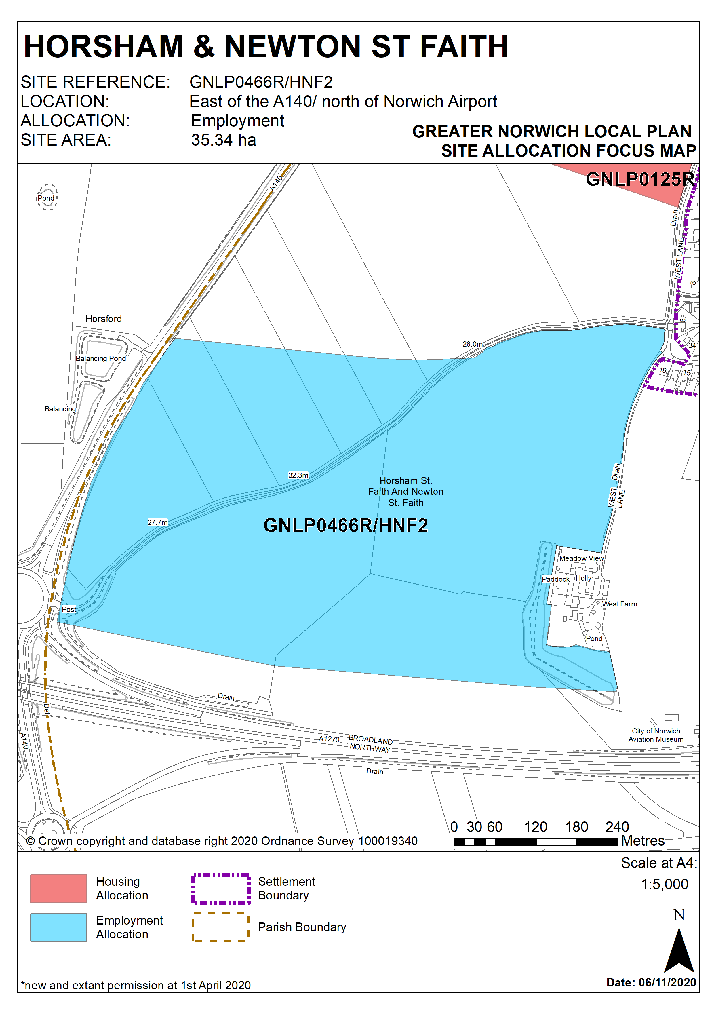
This site to the east of the A140 and north of Norwich Airport was allocated in the 2016 Broadland Local Plan but has yet to be developed at the base date of this plan. The principle of development on the site has already been accepted and it is expected that development will take place within the new local plan time-period up to 2038. The site is allocated for a full range of employment/commercial development, including those benefitting from a location close to the airport.
Policy HNF2/ GNLP0466R
STRATEGIC ALLOCATION
Land east of the A140 and north of Norwich International Airport, Horsham St Faith (approx. 35ha) is allocated for employment uses. This will be to provide a full range of employment uses including for those benefitting from a location close to the airport.
It is expected:
- Uses to be within use classes E(g), B2 and B8, with a maximum of 50% of total floorspace to be within any one use class.
- Substantial tree belts and landscaping to be provided at the boundaries of the site, with particularly extensive provision made at the north and eastern boundaries to provide a buffer to residential properties. Civil Aviation Authority guidance should be followed to ensure aviation hazards posed by wildlife are minimised
- Access to be provided directly from the A140 Northern Distributor Road interchange, with a possible second point of access from the northern part of the site to the A140.
- A masterplan is to be produced for the site showing a coordinated approach to bringing forward the development, particularly in relation to access provision including coordination with the NDR any necessary off-site highway improvements, and the early provision of landscaping to mitigate visual impacts. Accordingly, development is to be in two phases: Phase 1 the south-western, north-western and north-eastern parts of the site; Phase 2 the south-eastern portion.
The development will be expected to address the following specific matters:
- In order to achieve a range of employment uses (E(g) Business – offices, research and development, and light industry, B2 general industrial, B8 storage or distribution) and limit traffic generation it is envisaged that the amount of floorspace in one use class will not exceed 50% of the total floorspace within the overall development.
- Phase 1, the major part (approx. 29.6ha), will reflect the provision of access being from the west, and the need to provide treebelts and landscaping to the north and eastern boundaries in the early stages.
- Phase 2 (approx. 5.2ha) is expected to progress in the later stages of development as needed and related to the provision of infrastructure.
- Further public transport, pedestrian, cycling and highway infrastructure improvements will need to be agreed with the Highway Authority.
- Highway improvements may be needed to upgrade the junctions to deal with traffic generated by the development.
- The appropriate pollution control techniques should be installed to ensure that no harm comes to the water environment.
- Norfolk Minerals and Waste Core Strategy Policy CS16 applies, as this site is underlain by safeguarded minerals resources. The benefits of extracting the minerals, if feasible, will be taken into consideration.
- Archaeological investigation must be undertaken prior to any development.
Policy Map