5.5
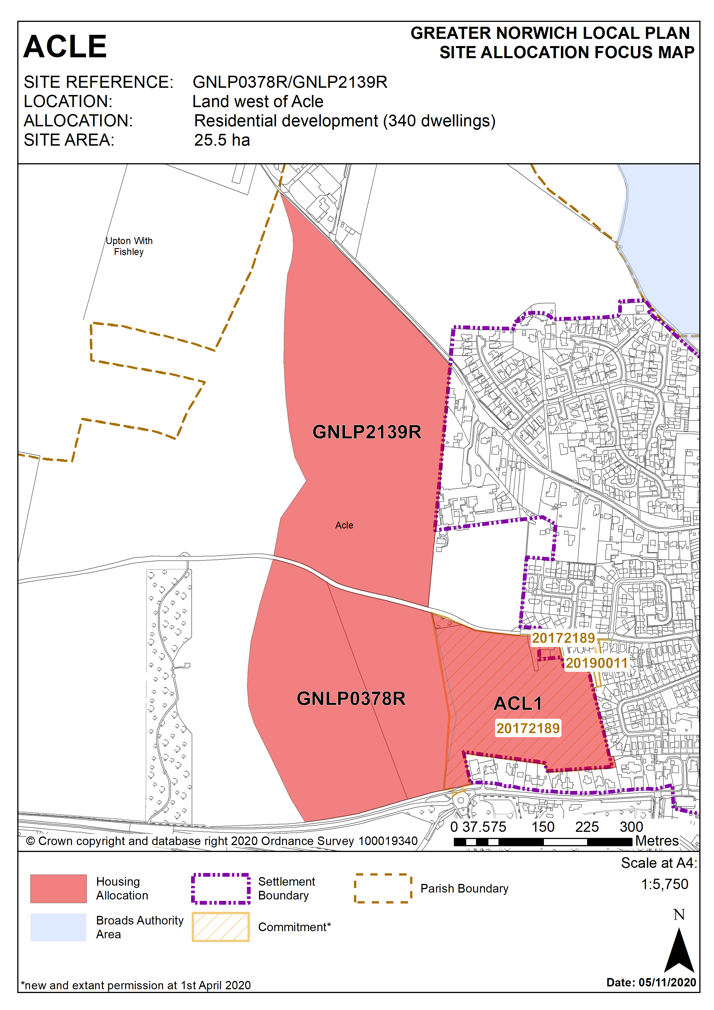
These two sites are combined to form one allocation. The site boundaries have been determined due to the need to: avoid substantial areas of flood risk; provide open space to reduce leisure visits to the Broads; enable future expansion of Acle Academy; and provide a link road from Norwich Road to South Walsham Road; but to do this without producing an allocation which is out of scale with the village. Developers will need to liaise with Acle Academy to ensure the school’s potential future growth needs will not be compromised. The reservoir to the west of the site was built to category A, nonetheless its existence and any associated risks may have implications for the design and layout of the site which need to be considered. The allocation of this site is subject to access via carried forward Broadland Local Plan allocation ACL1 and provision of walking, cycling, horse riding and emergency access via Mill Lane. Works to upgrade the unmade section of Mill Lane will also be required. The site is allocated at a lower gross density as the highway improvements, surface water drainage and open space requirements are significant. The eventual net density will be in line with the indicative minimum in Policy 2.
Policy GNLP0378R/GNLP2139R
Land west of Acle (north of Norwich Road, south of South Walsham Road, approx. 25.5 ha) is allocated for residential development. This will accommodate at least 340 homes, associated open space and community facilities.
More homes may be accommodated, subject to an acceptable design and layout, as well as infrastructure constraints.
The development will be expected to address the following specific matters:
- Preparation of masterplan to guide the development of the two sites, submitted as part of the application for planning permission.
- Early assessment of the junction and the A47 at this location is required.
- The site’s proximity to the Broads
The masterplan should demonstrate:
- Provision of a link road between Norwich Road and South Walsham Road of a sufficient standard to accommodate HGV and agricultural traffic
- Access (vehicular and pedestrian) provided through allocation ACL1 to the east.
- The Public Right of Way along Mill Lane is protected for continued use as a footway and bridle path
- Development does not prevent the potential future expansion of Acle Academy
- Open space providing leisure opportunities and enhancing the green infrastructure network
- Off-site requirements may include a footway along the west of Mill Lane, east at South Walsham Road and other improvements to the highway network as required by the Highway Authority.
- Mitigation and further investigation with regards to site susceptibility to surface water flooding and any potential risk of flooding from the reservoir.
Policy Map