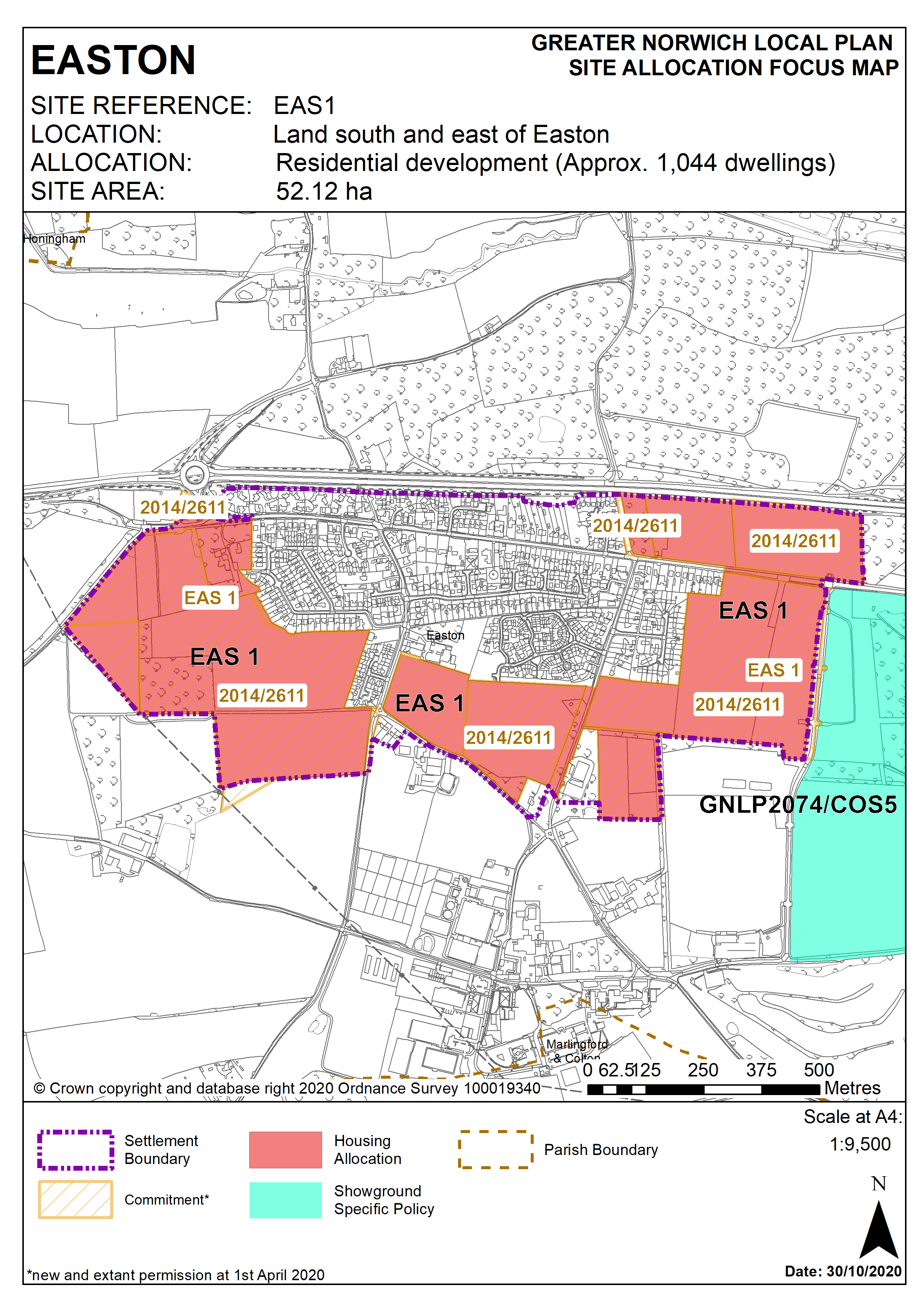
3.42
The site was allocated in 2015 as part of the South Norfolk Local Plan but has not yet been developed. The principle of development on the site has already been accepted and it is expected that development will take place within the time-period of this local plan up to 2038. The site has outline planning permission for 890 units, but this does not cover the whole of the allocation. A separate application for 64 dwellings is under consideration at the time of preparing this plan on some of the remaining allocated land, north of Dereham Road. In addition it is considered that there is capacity for an additional 90 dwellings on the last parcel of allocated land, to the east of Easton Gymnastics Club. The site is therefore re-allocated for residential development and has been considered in the calculation of the housing requirement for a total of 1,044 units. It is recognised that a number of the policy requirements will have already been met through the planning consent on the site.
Policy EAS1
Strategic Allocation
Land south and east of Easton (approx. 52.12 ha) is allocated for residential development and associated infrastructure. This will accommodate approximately 1,044 homes.
The development will be expected to address the following specific matters:
Master Plan
A comprehensive masterplan which will need to cover the provision of social and green infrastructure and highways improvements, taking into account the other requirements of this policy, and address:
- Phasing which clearly identifies when key infrastructure will be provided in relation to the provision of new housing. Phasing should be designed to ensure development minimises the disturbance to existing residents.
- The relationship to any continued expansion of Easton College and the Royal Norfolk Showground (including the loss of any land currently used for Showground parking).
- The approach to densities across the allocation, including higher densities close to the proposed village centre.
- Careful consideration of development west of the allotments, including the possible retention of this area as open space.
- A local centre at the heart of the development, easily accessible to surrounding residential areas.
Enhanced Facilities
- Provision of a new village centre in the vicinity of the indicative site shown on the Easton Inset Map, to include a new village hall, village green/focal recreation space, shared parking provision with primary school.
- Expanded primary school provision in agreement with the Education Authority.
Heritage Assets
- Application to be accompanied by an assessment of the significance of St Peter’s Church as a heritage asset, the extent of its setting and the contribution that its setting makes to its significance.
- Any development must conserve and enhance the significance of the grade I listed Church of St Peter including any contribution made to that significance by setting. This includes but is not limited to ensuring that sufficient open space and landscaping is retained to the south, south east and south west of St Peter’s Church and that sufficient planting is provided, such that its setting, and the wooded setting of Diocesan House and the Vicarage, are protected
Landscaping and Green Infrastructure
- Protection of the existing allotments and any other sites in community use, or relocation to an equivalent or better site.
- Provision of a landscape buffer and enhancements to the A47 corridor – layout and landscaping should take into account both visual enhancement and the noise implications of the neighbouring A47 and Showground and include any proposals for acoustic barriers.
- Identification and protection of significant biodiversity features including trees and hedgerows, incorporated within open space and with off-site mitigation where on-site protection cannot be achieved.
- Green infrastructure enhancements, including the approach to the area between the village and Easton College.
- Proportionate contributions to the access improvements to the Yare Valley and Bawburgh/Colney Lakes.
Transport
Highways and transport improvements agreed with Norfolk County Council and, where appropriate, the Highways Agency, to include;
- Proportionate contributions to short, medium and long-term improvements to the A47 Easton and Longwater junctions to ensure that junction capacity does not become a constraint on development.
- Provision of new vehicular accesses for development to the south of the village, to supplement Marlingford Road and Bawburgh Road.
- Provision for, and proportionate contributions to, Dereham Road Bus Rapid Transit (BRT), including improved access to facilities in Costessey, and other public transport enhancements in accordance with the latest version of the Norwich Area Transportation Strategy (NATS) implementation plan.
- Safe and convenient pedestrian and cycle links to key locations, including Longwater employment and retail, Costessey Medical Centre, Ormiston Victory Academy, Costessey Park and Ride site and Easton College.
Site conditions and constraints
- Norfolk Minerals and Waste Core Strategy Policy CS16 applies, as this site is underlain by safeguarded minerals resources. The benefits of extracting the minerals, if feasible, will be taken into consideration.
- Investigation of ground conditions at the former gravel pit north of Dereham Road.
- Wastewater infrastructure capacity must be confirmed prior to development taking place.
- Site layout to take account of water mains and sewers crossing site.
Policy Map