3.6
The site was allocated in 2015 as part of the South Norfolk Local Plan. Science park and hospital related uses remain appropriate, and COL 1 is re-allocated as a strategic employment allocation.
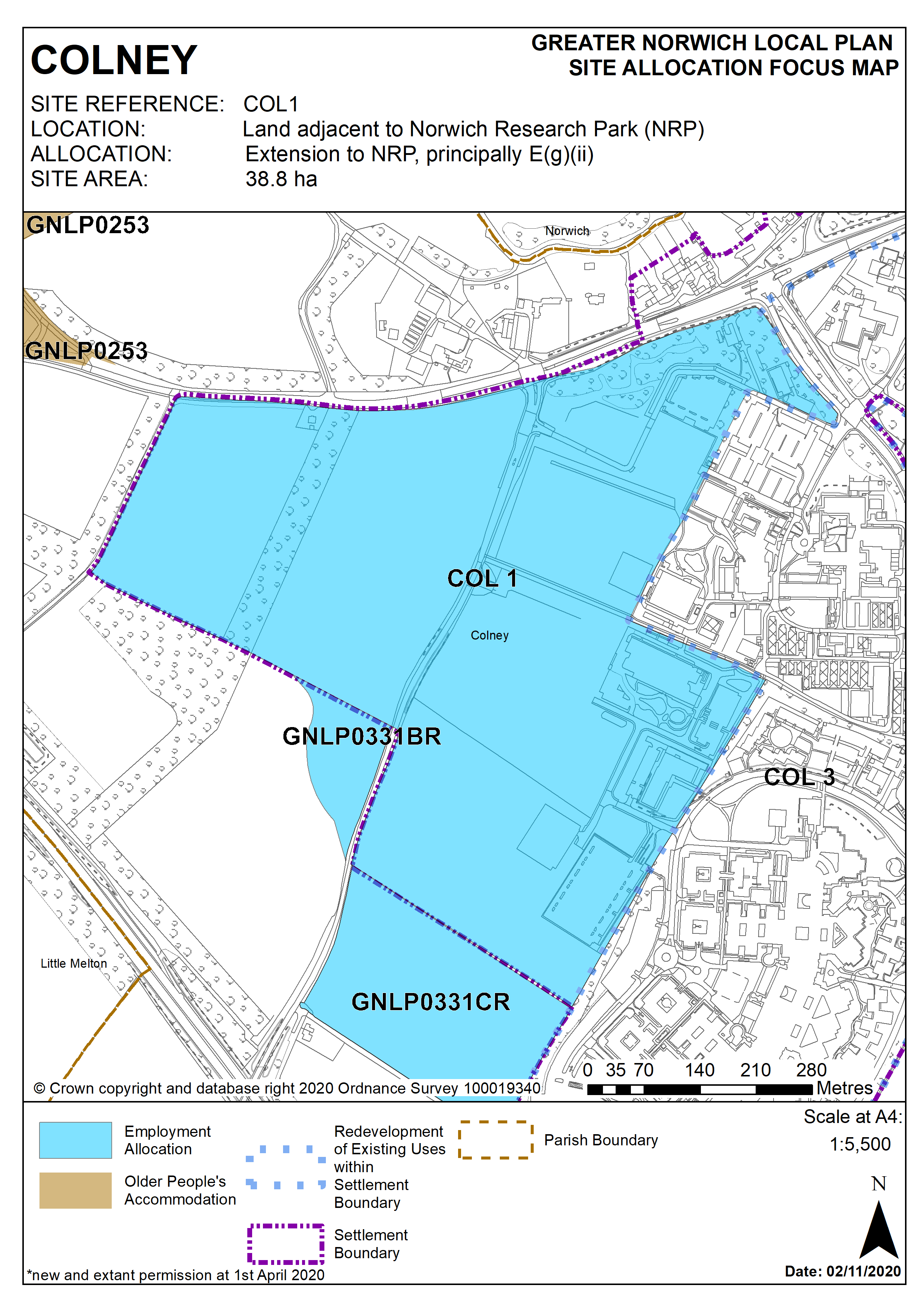
Policy COL 1
Strategic Allocation
Land adjacent to Norwich Research Park (NRP), Colney (approx. 38.8 ha) is allocated principally for an E (gii) Science Park development, hospital expansion and other proposals ancillary and complementary to these main uses.
The development will be expected to address the following specific matters:
Uses
- Acceptable uses will be research and development use under Class E (gii) ‘research and development’ of the Town and Country Planning (Use Classes) Order 2020 (as amended) plus hospital and hospital related uses. Other uses clearly ancillary to the main functions of the Norwich Research Park (NRP) and/or complementary to the main anchor institutions will also be acceptable.
Master plan/infrastructure plan
- Provision of a masterplan (having regard to the masterplan associated with planning permission 2012/1880, as appropriate), that includes: phasing in relation to the delivery of infrastructure and integration with existing uses; provision of high-quality buildings and spaces; and a landscape strategy and green infrastructure plan.
- The masterplan should be supported by a utilities/infrastructure plan which will include the necessary transport improvements detailed below.
- Proposals for smaller sites within the overall allocation should accord with the principals of any agreed masterplan and infrastructure plan.
Transport
Measures which address the impacts of the proposed development, including where appropriate:
- Improvements to the B1108 Watton Road junctions which accesses the NRP.
- Improvements to the capacity at the B1108/A47 junction, to ensure that it does not become a constraint to development.
- Maintaining and enhancing safe and convenient access to the Norfolk and Norwich University Hospital.
- Public transport access and provision, to encourage significant modal shift to/from and within the wider NRP, including measures identified through the Transport for Norwich programme.
- Safe and convenient pedestrian and cycle links within the wider NRP and to/from significant areas of housing (specifically at Cringleford, Hethersett and Threescore/Bowthorpe), including completion of the Hethersett to NRP cycleway.
- Parking ratios of approximately 1 space per 60m2 of floor area (excluding plant).
- The developer should ensure that sufficient land is made available to deliver the required infrastructure.
Design and Landscape
- Landmark design quality, including a safe and attractive public realm, creating an integrated approach to existing and new development at the NRP.
- Exemplar sustainable development, achieving at least BREEAM ‘very good’ standard for new construction.
- Development contributes positively to green infrastructure and the landscape setting including retention of the existing shelter belts, hedgerows and significant trees and linking of features to the wider landscape.
- Development density to reflect the transport constraints of the locality and the aspirations for design quality and landscaping.
- Any development must conserve and enhance the significance of the Old Hall and its wall and the Rectory, including any contribution made to that significance by setting. This includes but is not limited to appropriate landscaping, density and design.
Constraints
- Site specific flood risk assessments.
- Layout to take account of water main and sewers crossing the site;
- Historic Environment Record to be consulted to determine any need for archaeological surveys prior to development.
- Norfolk Minerals and Waste Core Strategy Policy CS16 applies, as this site is underlain by safeguarded minerals resources. The benefits of extracting the minerals, if feasible, will be taken into consideration.
Policy Map