2.188
The site was allocated in the previous Local Plan and the western part of the original allocation at Geoffrey Watling Way has been developed. Much of the remaining land on the river frontage (Carrow Quay) has benefit of planning permission and the first phase of development is underway. Land at the football club car park and Groundsman’s Hut site remains appropriate for development; the latter site has now got planning permission for 73 units of housing (Carrow View). The principle of development on the site has already been accepted, and it is expected that development will take place within the new local plan time-period up to 2038. The site is re-allocated for residential development. As an existing allocation it has been considered in the calculation of the housing requirement.
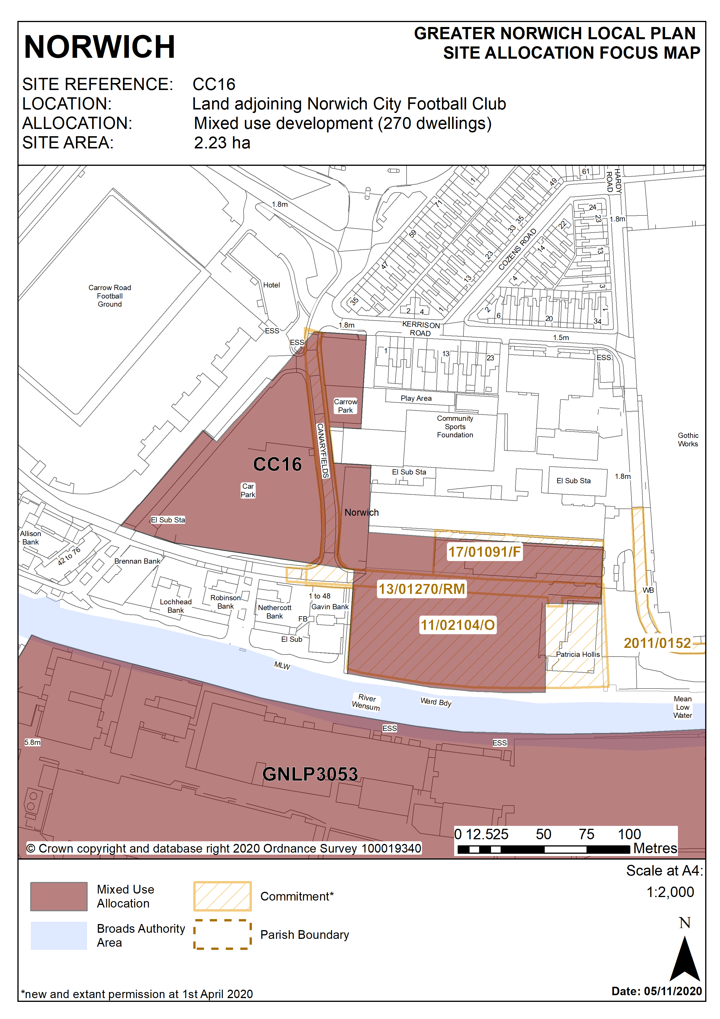
2.189
The site is located to the east of city centre and is 2.23 hectares in size. It straddles the city centre boundary with most of the western part of the site within the defined city centre area. The majority of the land is currently used as surface car parking.
2.190
Norwich City Football Club’s Carrow Road stadium is immediately to the west of the site, and the southern part of the site is adjacent to the River Wensum, with factory and food processing at Carrow Works opposite. To the north and east is ATB Laurence Scott’s buildings at both the Gothic Works site and the engine test bed building. Further north is a residential area with mainly two-storey Victorian terraced houses. The main point of access to the site is from the north-west corner at the junction of Carrow Road and Kerrison Road.
2.191
This part of the city has traditionally been a manufacturing area; however it is increasingly being developed for housing and a mix of uses.
2.192
The development of this site for a mix of uses will deliver high density housing and contribute to the regeneration of the wider east Norwich area, making efficient use of its highly accessible location close to public transport routes, the railway station, and the strategic cycle route network. Its current use for surface car parking is an inefficient use of the site.
2.193
Development must address the site’s constraints which include its location adjacent to the River Wensum, flood risk, possible contamination, access capacity. Development of the site must be of a scale and form which respects and takes advantage of its riverside context and location in respect to the Broads National Park.
2.194
The south of the site along the river, and the south eastern corner is vulnerable to noise from the railway and especially its bridge, access and location of a small part of the site being within Trowse railhead consultation area, therefore appropriate mitigation measures are required to mitigate the noise impact on the proposed development.
2.195
The site should be housing-led but could also include other ancillary uses including small-scale office and retail units to serve local needs only; any non-residential uses will be expected to provide minimal and operational parking needs only.
2.196
The future development of this site is critical to unlocking the regeneration of the wider area, specifically the Carrow Works site (GNLP3053), Utilities site (R10), and Deal Ground (GNLP0360), of which some are constrained in terms of access. Development of all these sites requires a comprehensive approach to be taken to access, particularly in terms of public transport links and pedestrian and cycle links.
2.197
The development must provide access for public transport and an associated interchange on site, and include a public transport strategy for the wider east Norwich area. This will enable the proposed development sites referred to above to link with the railway station / riverside area and the city centre.
2.198
Given the site’s highly accessible location and the intention to provide new public transport links it is considered suitable to include car-free housing. In any event car parking levels should be kept low.
2.199
The development must also provide for access to the river, and provision of riverside walk along its river frontage, as part of the proposed strategic cycle and pedestrian link from the city centre to Whitlingham Broad.
2.200
The development must be designed to minimise the impact of noise generation, light and odour pollution from adjacent industrial uses on new residential occupiers.
2.201
There are several listed factory buildings adjacent to the south of the river. The impact of development on the conservation area and river frontage must be carefully considered. The site is also adjacent to important Palaeolithic deposits which will require archaeological evaluation.
2.202
Consideration should also be given to the safe and successful continued functioning of the football club, creating a high quality design overall.
2.203
This site lies adjacent to the River Wensum. It is recommended that developers engage in early discussions with the Environment Agency.
2.204
Development needs to ensure that the water environment is protected throughout the development of the site. The site falls within Source Protection Zone 1, designated to protect water supplies, and therefore the water environment is particularly vulnerable in this location. Detailed discussions over this issue will be required with the Environment Agency to ensure that proposals are appropriate for the site and that the site is developed in a manner which protects the water environment.
2.205
The site is likely to accommodate up to 200 homes on the currently undeveloped part of Carrow Quay site and a minimum of 70 homes on the groundsman’s hut/car park site. More may be accommodated, subject to an acceptable design and layout etc. being achieved.
Policy CC16
Land adjoining Norwich City Football Club north and east of Geoffrey Watling Way, Norwich (approx. 2.23ha) is allocated for mixed use development to include residential, leisure, community, office and ancillary small retail uses. This will accommodate a minimum of 270 homes.
The development will achieve the following site-specific requirements:
- Achievement of a high quality, locally distinctive design of a scale and form which respects its riverside context, ensures a high level of flood resilience and incorporates appropriate mitigation measures (including addressing identified risks from flooding from rivers and surface water flooding);
- Conserve and enhance the setting of the adjacent Bracondale Conservation Area and nearby statutory listed buildings and scheduled monuments (including Carrow Priory & Boom Towers) (including any contribution made to their significance by setting)
- Provide a public transport interchange on site and a public transport strategy for the wider east Norwich strategic regeneration area
- Provide public access to the river and a riverside walk/cycle link to facilitate the re-routing of national cycle route 1 / red pedalway to Whitlingham and connections to the regeneration opportunity sites to the south and east including the Deal Ground, the Utilities site and Carrow Works in accordance with policy 7.1 and the ‘River Wensum Strategy’.
- Enhance the river frontage as a gateway to Norwich city centre
- Be designed to mitigate the impact of noise generation, light and odour pollution from adjacent industrial uses and the railway
- High quality green infrastructure, landscaping, planting and biodiversity enhancements particularly along the river edge and forming a setting for the stadium;
- Norfolk Minerals and Waste Core Strategy Policy CS16 and NPPF ‘agent of change’ principle applies, as part of this site is within the consultation area of a safeguarded mineral infrastructure (aggregate and roadstone railhead and asphalt plant).
Policy Map