MAP1 - Multiple
Page -
Modification
Update all settlement maps throughout the plan to reflect the re-referencing of sites (title and map).
Reasons
Re reference on adoption of plan
MAP2 - Multiple
Page -
Modification
Update all focus maps throughout the plan to reflect the re-referencing of sites (title and map). Remove commitment layer and associated note.
Reasons
Re-reference on adoption of plan
MAP3 - Norwich settlement maps
Page 7-9
Modification
Update the three Norwich settlement maps (North, South and Centre) as appropriate:
Norwich (North) -
Boundary changes for GNLP0466R/HNF2, GNLP1061
Deletion of sites GNLP1019/HEL4
Norwich (South) -
Boundary changes for R1
Deletion of sites GNLP2043/0581, R2, CC2, CC13
Reflect combined Colney allocation
Norwich (Centre) -
Deletion of sites CC2 and CC13
Reasons
To reflect changes to site allocations
MAP4 - East Norwich Focus Map (Moved to Strategic Sites section)
Page 20
Modification
Update Location information in title to read:
East Norwich Stragetic Strategic Regeneration Area - Deal Ground, Carrow wWorks and Utilities Site and Land in front of ATB Lawrence Scott
Update Allocation information in the title to read:
Mixed Use (4000 dwellings)
Reasons
To reflect amendments to policy and to correct typographical error
MAP5 - GNLP1061R Focus Map (Moved to Strategic Sites section)
Page 58
Modification
Update Allocation information in the title to read:
Aviation related employment and, aviation educational uses and general employment
Update Site Area information in the title to read:
42.46 ha 43.66 ha
Amend boundary of allocation on map to reflect change to site area.
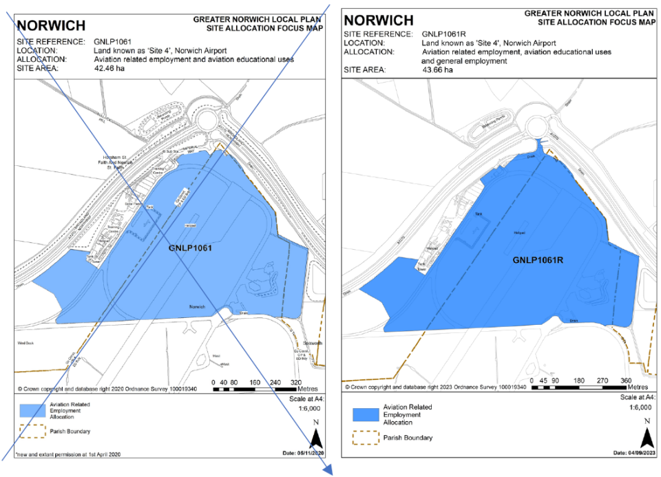
Reasons
To reflect amendments to policy and change to site area
MAP6 - GNLP2164 Focus Map
Page 67
Modification
Remove withdrawn allocation CC13 from the GNLP2164 Focus Map.
Reasons
Site deleted from plan
MAP7 - CC2 Focus Map
Page 74
Modification
Delete Focus Map for withdrawn CC2 allocation.
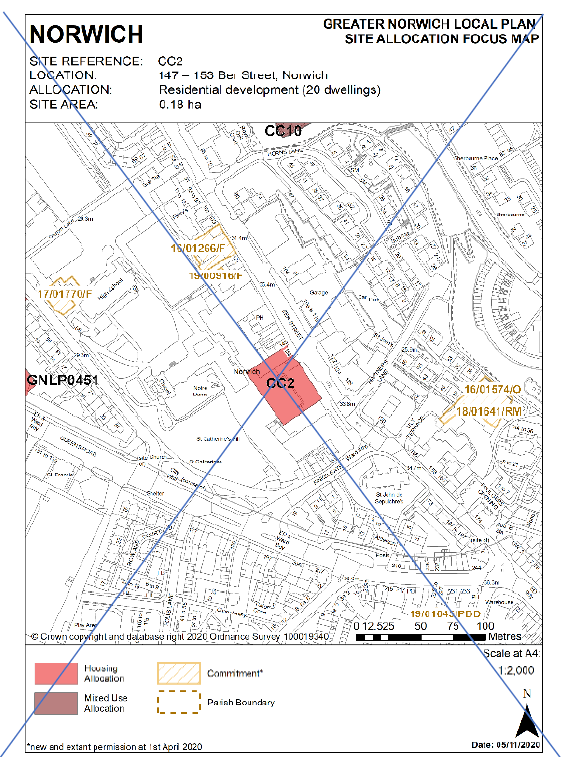
Reasons
Site deleted from plan
MAP8 - CC13 Focus Map
Page 99
Modification
Delete Focus Map for withdrawn CC13 allocation.
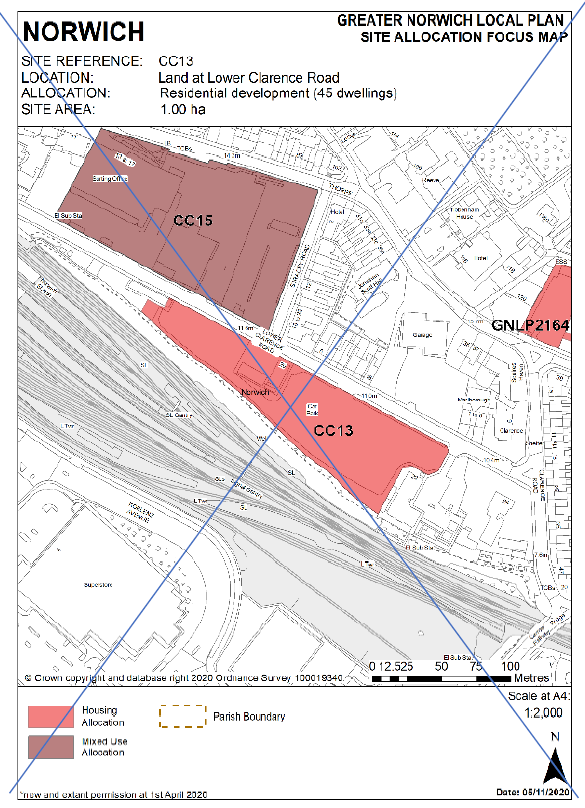
Reasons
Site deleted from plan
MAP9 - CC15 Focus Map
Page 102
Modification
Remove withdrawn allocation CC13 from the CC15 Focus Map.
Reasons
Site deleted from plan
MAP10 - CC18 (CC19) Focus Map
Page 109
Modification
Amend Location information in the title to read:
Land at 140 150-154 Oak Street and 70-72 Sussex Street
Reasons
To correct drafting error
MAP11 - R1 Focus Map
Page 120
Modification
Amend Site Area information in the title to read:
4.51 ha 3.45 ha
Amend boundary of allocation on map to reflect change to site area to omit developed area of site.
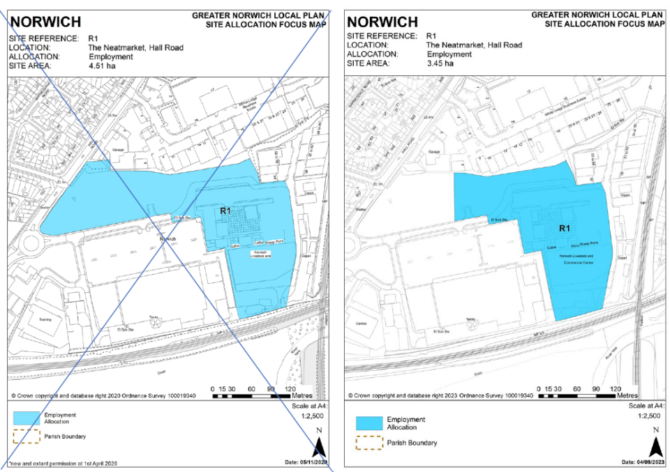
Reasons
The north-west section of the site has recently been developed as such is no longer available for allocation.
MAP12 - R2 Focus Map
Page 123
Modification
Delete Focus Map for withdrawn R2 allocation.
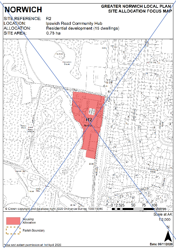
Reasons
Site deleted from plan
MAP13 - R37 Focus Map
Page 163
Modification
Amend Allocation information in the title to read:
Mixed Use (80 200 dwellings)
Reasons
To reflect change to number of dwellings
MAP14 - R38 Focus Map (Moved to Strategic Sites section)
Page 165
Modification
Amend Allocation information in the title to read:
Mixed Use (900 755 dwellings)
Reasons
To reflect change to number of dwellings
MAP15 - Colney Settlement Map
Page 171
Modification
Amend the Colney Settlement Map as appropriate to reflect combining of sites COL1, GNLP0331BR and GNLP0331CR into one allocation.
Delete Costessey Contingency site from map.
Reasons
Sites combined into a single allocation
MAP16 - COL1 Focus Map
Page 174
Modification
Delete Focus Map for COL1 allocation.
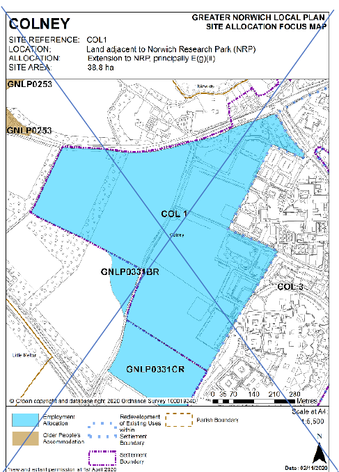
Reasons
Sites combined into a single allocation
MAP17 - GNLP0331BR Focus Map
Page 176
Modification
Delete Focus Map for GNLP0331BR allocation.
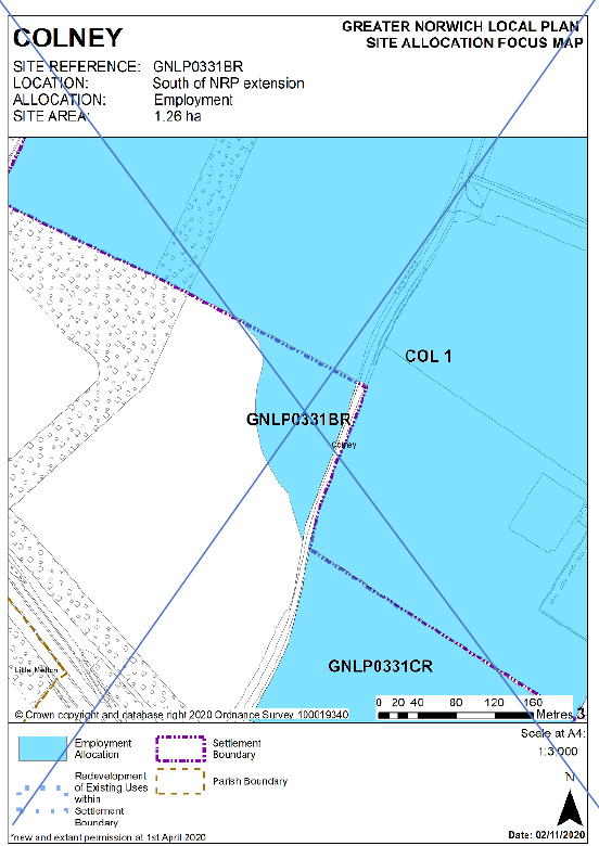
Reasons
Sites combined into a single allocation
MAP18 - GNLP0331CR Focus Map
Page 178
Modification
Delete Focus Map for GNLP0331CR allocation.
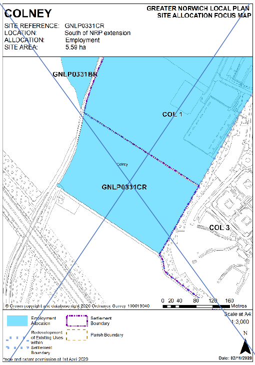
Reasons
Sites combined into a single allocation
MAP19 - COL1/ GNLP0331BR/ GNLP0331CR (Moved to Strategic Sites section)
Page -
Modification
New Focus Map for combined allocation.
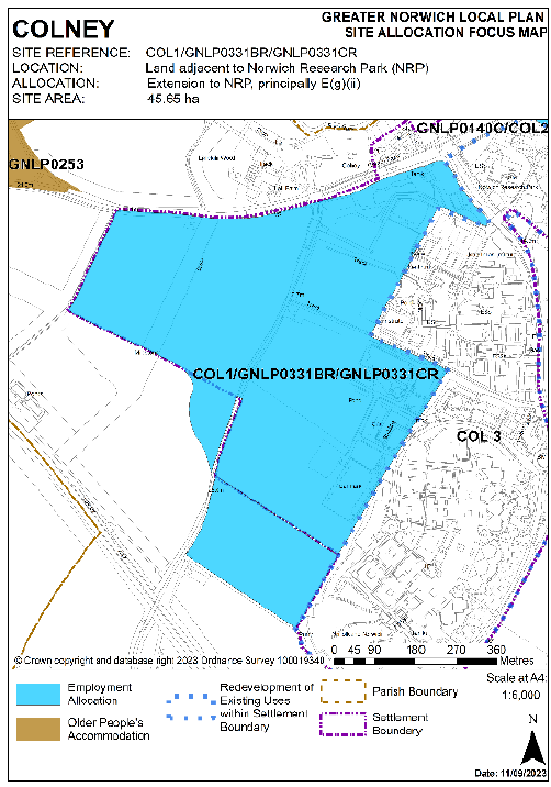
Reasons
Sites combined into a single allocation
MAP20 - COL3 Focus Map
Page 182
Modification
Update Focus Map to reflect combined COL1 allocation.
Reasons
Sites combined into a single allocation
MAP21 - BAW2 Focus Map
Page 187
Modification
Delete Costessey Contingency site from map.
Reasons
Site deleted from plan
MAP22 - Costessey Settlement Map
Page 189
Modification
Reflect COS3 boundary change.
Delete Costessey Contingency site from map.
Reasons
To reflect changes to site area and deletion of Costessey Contingency site
MAP23 - COS3/ GNLPSL2008 Focus Map (Moved to Strategic Sites section)
Page 191
Modification
Update Site Area information in the title to read:
15.29 ha 11.06 ha
Amend boundary of allocation on map to reflect change to site area.
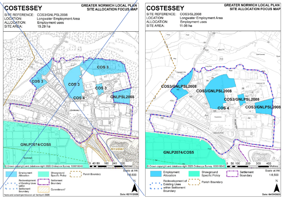
Reasons
To reflect changes to site area
Map24 - COS4 Focus Map
Page 193
Modification
Amend boundary of COS3/GNLPSL2008 allocation on map to reflect change to site area.
Reasons
To reflect changes to site area
MAP25 - COS5/ GNLP2074 Focus Map
Page 195
Modification
Amend Location information in the title to read:
Royal Norfolk Showground
Amend boundary of COS3/GNLPSL2008 allocation on map to reflect change to site area.
Reasons
To reflect changes to site area
MAP26 - Cringleford Settlement Map
Page 197
Modification
Update the Cringleford Settlement Map to reflect the combined COL1 allocation.
Reasons
Sites combined into a single allocation
MAP27 - GNLP0307/ 0327 Focus Map (Moved to Strategic Sites section)
Page 201
Modification
Update Focus Map to reflect combined COL1 allocation.
Reasons
Sites combined into a single allocation
MAP28 - Drayton Settlement Map
Page 205
Modification
Update the Drayton Settlement Map to reflect the deletion of allocation HEL4/GNLP1019
Reasons
Site deleted from plan
MAP29 - EAS1 Focus Map (Moved to Strategic Sites section)
Page 213
Modification
Amend Allocation information in the title to read:
Residential development (Approx 1,044 962 dwellings)
Reasons
To reflect change to number of dwellings
MAP30 - Hellesdon Settlement Map
Page 215
Modification
Amend the Hellesdon Settlement Map to reflect deletion of allocation HEL4/GNLP1019
Reasons
Site deleted from plan
MAP31 - HEL4/GNLP1019 Focus Map
Page 223
Modification
Delete Focus Map for deleted HEL4/GNLP1019 allocation.
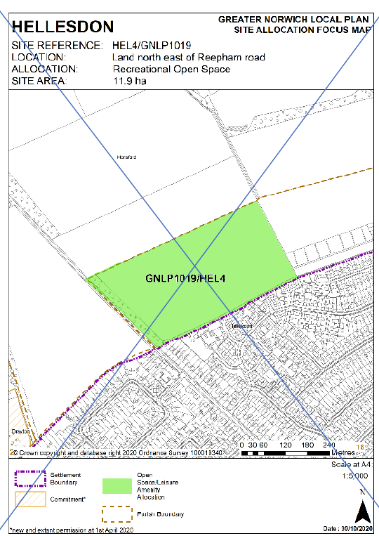
Reasons
Site deleted from plan
MAP32 - GNLP0132 Focus Map
Page 238
Modification
Amend Allocation information in the title to read:
Residential development (1200 1,000-2,000 dwellings)
Reasons
To reflect change to number of dwellings
MAP33 - Taverham Settlement Map
Page 241
Modification
Amend the Taverham Settlement Map to reflect amended boundary to GNLP0159R and GNLP0337R.
Reasons
To reflect changes to allocation boundary
MAP34 - GNLP0337R Focus Map
Page 244
Modification
Amend Site Area information in the title to read:
81.69ha 78.5ha
Amend boundary of allocation on map to reflect change to site area.
Reasons
To reflect amended site area
MAP35 - GNLP0159R Focus Map
Page 246
Modification
Amend Focus Map to reflect larger site boundary and increased number of units
Amend Allocation information in the title to read:
Residential development (12 25 dwellings)
Amend Site Area information in the title to read:
0.97 ha 2.00 ha
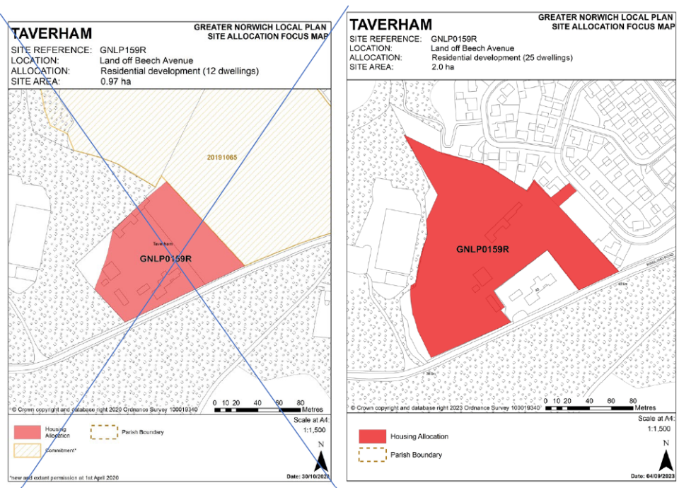
Reasons
Update to site boundary and number of dwellings
MAP36 - Wymondham Settlement Map
Page 304
Modification
Remove rogue 0525 reference from Wymondham settlement map
Include Gypsy and Traveller sites GNLP5028 A and B
Reasons
To correct error
To add Gypsy and Traveller site
MAP37 - ACL2 Focus Map
Page 318
Modification
Amend the Site Area to read:
2.2 ha 2.0ha
Reasons
To ensure area is consistent between policy and map
MAP38 - GNLP2161 Focus Map
Page 324
Modification
Amend the Location information in the title to read:
Land adjacent adjacent to Norwich Camping & Leisure, off Yarmouth Road
Reasons
To correct drafting error
MAP39 - Brundall Settlement Map
Page 328
Modification
Amend the Brundall Settlement Map to remove deleted allocations BRU2 and BRU3
Reasons
Sites deleted from plan
MAP40 - BRU2 Focus Map
Page 330
Modification
Delete Focus Map for withdrawn BRU2 allocation.
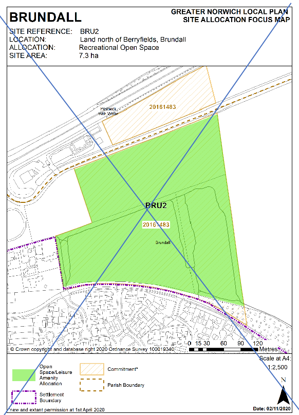
Reasons
Site deleted from plan
MAP41 - BRU3 Focus Map
Page 332
Modification
Delete Focus Map for withdrawn BRU3 allocation.
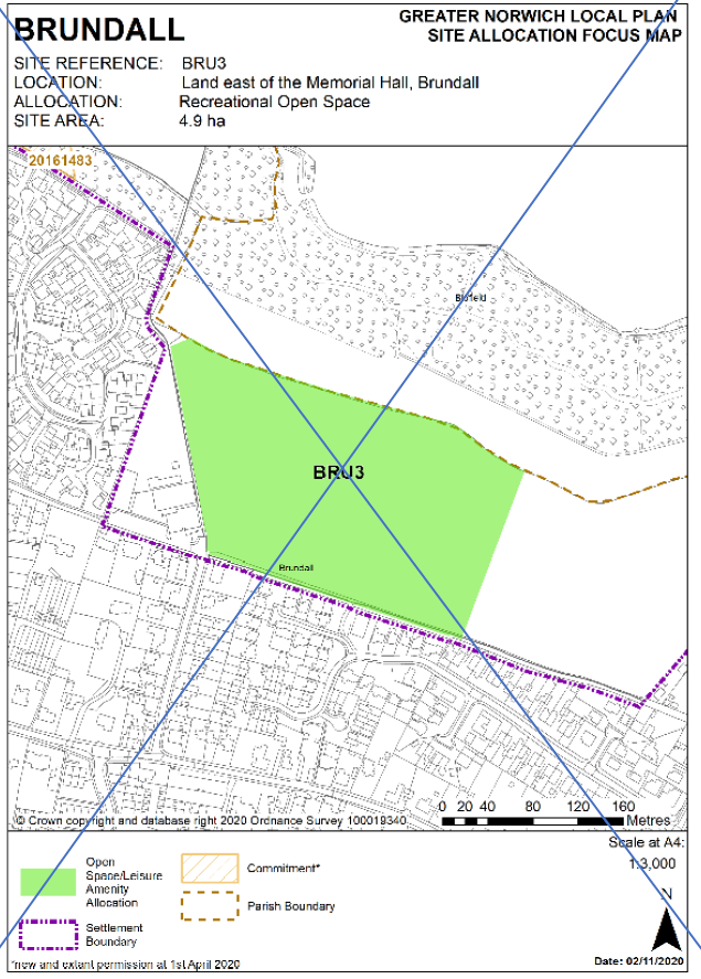
Reasons
Site deleted from plan
MAP42 - HET2 Focus Map
Page 340
Modification
Amend the Site Area to read:
4.0ha 3.8ha
Reasons
To ensure area is consistent between policy and map
MAP43 - HET3 Focus Map
Page 342
Modification
Amend the Site Area to read:
6.83 ha 6.6 ha
Reasons
To ensure area is consistent between policy and map
MAP44 - Hingham Settlement Map
Page 344
Modification
Amend the Hingham Settlement Map to reflect deletion of withdrawn allocation GNLP0503
Reasons
Site deleted from plan
MAP45 - GNLP0503 Focus Map
Page 345
Modification
Delete Focus Map for withdrawn GNLP0503 allocation.
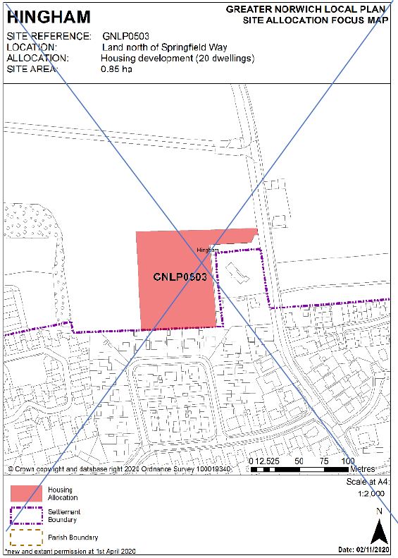
Reasons
Site deleted from plan
MAP46 - BLO5 Focus Map
Page 379
Modification
Amend the Location information in the title to read:
Land to the north of Blofield Corner, opposite 'Heathway'
Reasons
To correct drafting error
MAP47 - Buxton Settlement Map
Page 381
Modification
Amend title to read 'Buxton with Lamas'
Reasons
To correct drafting error
MAP48 - Cantley Settlement Map
Page 386
Modification
Add the Broads Authority area to the Cantley Settlement Map and show on key
Reasons
To correct an error identified by Broads Authority
MAP49 - Cawston Settlement Map
Page 389
Modification
Amend the Cawston Settlement Map as appropriate to reflect the combining of sites GNLP0293 and CAW2 into one allocation
Reasons
Sites combined into single allocation
MAP50 - GNLP0293 Focus Map
Page 391
Modification
Delete Focus Map for GNLP0293 allocation
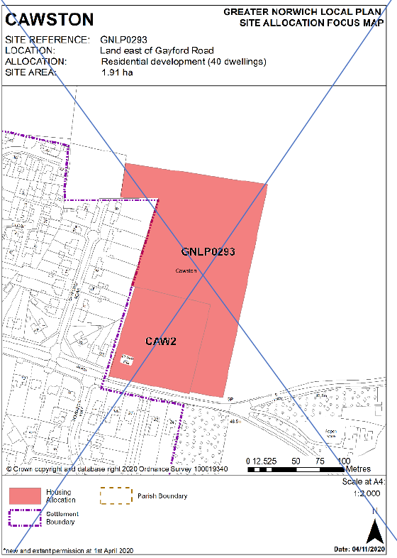
Reasons
Sites combined into single allocation
MAP51 - CAW2 Focus Map
Page 395
Modification
Delete Focus Map for CAW2 allocation
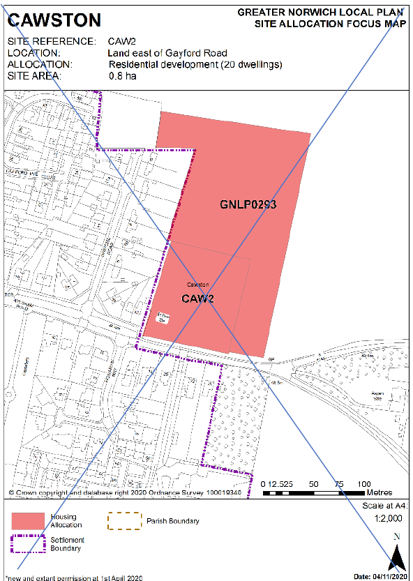
Reasons
Sites combined into single allocation
MAP52 - GNLP0293 and CAW2 Focus Map
Page -
Modification
New Focus Map for combined allocation.
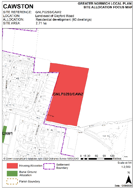
Reasons
Sites combined into single allocation
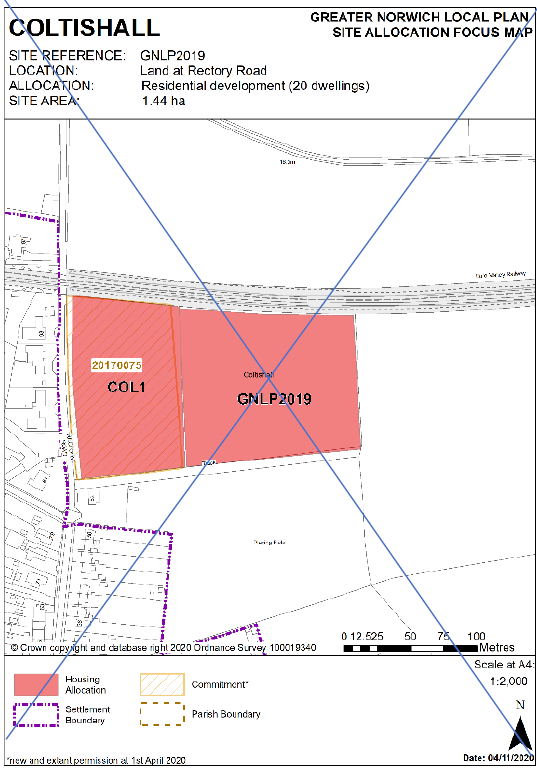
MAP53 - Coltishall Settlement Map
Page 397
Modification
Amend the Coltishall Settlement Map to reflect the combining of sites GNLP2019 and COL1 into one allocation
Add the Broads Authority area to the Coltishall Settlement Map and show on key
Reasons
Sites combined into single allocation
To correct an error identified by Broads Authority
MAP54 - GNLP2019 Focus Map
Page 399
Modification
Delete Focus Map for GNLP2019 allocation
Reasons
Sites combined into single allocation
MAP55 - COL1 Focus Map
Page 401
Modification
Delete Focus Map for COL1 allocation
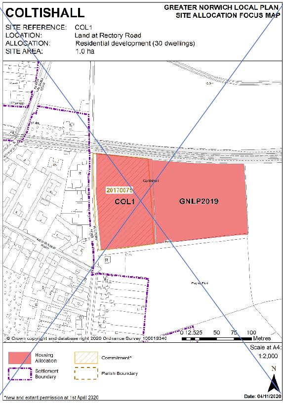
Reasons
Sites combined into single allocation
MAP56 - GNLP2019 and COL1 Focus Map
Page -
Modification
New Focus Map for combined allocation.
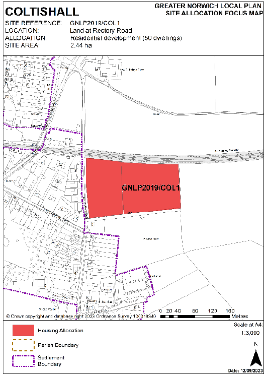
Reasons
Sites combined into single allocation
MAP57 - GNLP0605 Focus Map
Page 407
Modification
Amend the Location information in the title to read:
Land west of Foundary Foundry Close
Reasons
To correct drafting error
MAP58 - Horsford Settlement Map
Page 429
Modification
Amend the Horsford Settlement Map to reflect the amendment to the boundary of GNLP0264
Reasons
To reflect changes to site allocation boundary
MAP59 - GNLP0264 Focus Map
Page 431
Modification
Amend Focus Map to reflect smaller allocation area, number of dwellings and site area
Amend Allocation information in the title to read:
Residential development (45 30 dwellings)
Amend Site Area information in the title to read:
1.78 ha 1.38 ha
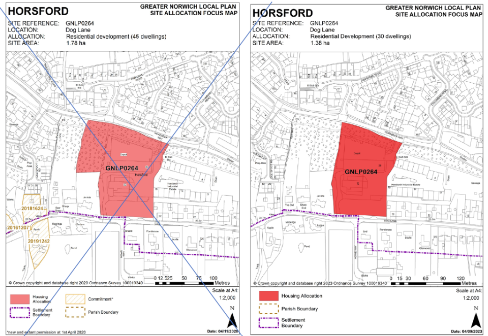 ;
;
Reasons
Site allocation reduced to remove area in Flood Zone 2
MAP60 - Horsham St Faith Settlement Map
Page 433
Modification
Amend the Horsham St Faith Settlement Map to reflect amendments to boundaries of sites HNF2/GNLP0466R and HNF3/SL2007/GNLP4061
Add Site GNLP1061R to the Horsham St Faith Settlement Map for clarity
Reasons
To reflect changes to site allocations as a result of the hearing sessions
To add site GNLP1061R to the settlement which has been missed in error
MAP61 - HNF2/ GNLP0466R Focus Map
Page 440
Modification
Amend Focus Map to reflect change to allocation boundary and site area
Amend Site Area information in the title to read:
35.34 ha 38 ha
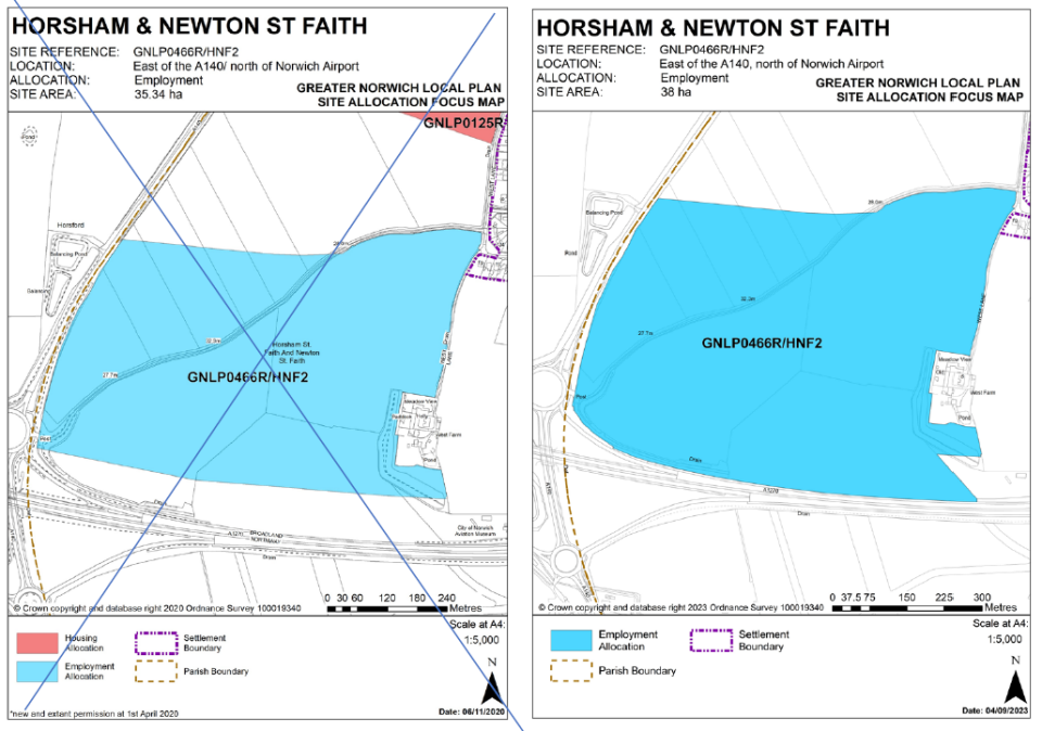
Reasons
To amend the boundary of the allocation to reflect current planning application
MAP62 - SL2007/ GNLP4061/ HNF3 Focus Map
Page 442
Modification
Amend Focus Map to reflect change to allocation boundary to include existing bund and remove built out area and update site area
Amend Site Area information in the title to read:
4.39 ha 4.30 ha
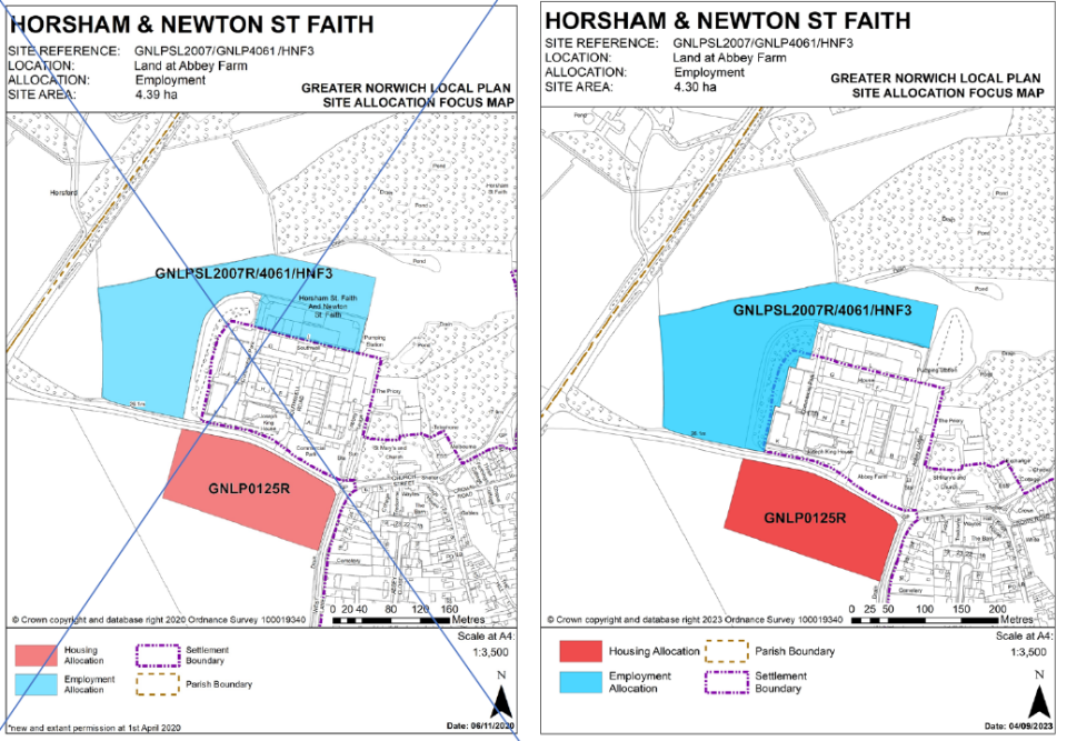
Reasons
To amend boundary to reflect changes agreed through hearing sessions
MAP63 - Marsham Settlement Map
Page 451
Modification
Amend the Marsham Settlement Map to reflect deletion of allocation GNLP2143
Reasons
Site deleted from plan
MAP64 - GNLP2143 Focus Map
Page 453
Modification
Delete Focus Map for GNLP2143 allocation
Reasons
Site deleted from plan
MAP65 - Reedham Settlement Map
Page 455
Modification
Amend the Reedham Settlement Map to reflect deletion of allocation GNLP3003
Reasons
Site deleted from plan
MAP66 - GNLP3003 Focus Map
Page 459
Modification
Delete Focus Map for GNLP3003 allocation
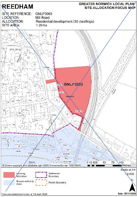
Reasons
Site deleted from plan
MAP67 - South Walsham Settlement Map
Page 465
Modification
Amend the South Walsham Settlement Map to reflect the combining of sites GNLP0382 and SWA1 into one allocation
Reasons
Sites combined into single allocation
MAP68 - GNLP0382 Focus Map
Page 467
Modification
Delete Focus Map for GNLP0382 allocation
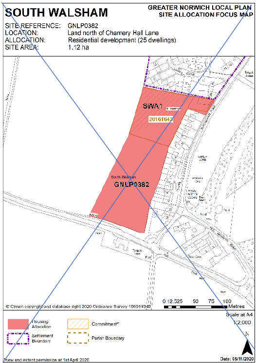
Reasons
Sites combined into single allocation
MAP69 - SWA1 Focus Map
Page 469
Modification
Delete Focus Map for SWA1 allocation
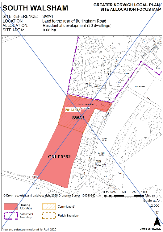
Reasons
Sites combined into single allocation
MAP70 - GNLP0382 and SWA1 Focus Map
Page -
Modification
New Focus Map for combined allocation
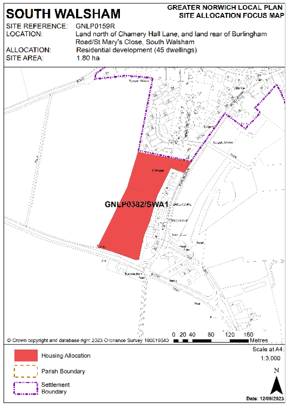
Reasons
Sites combined into single allocation
MAP71 - GNLP0581/2043 Focus Map
Page 476
Modification
Delete Focus Map for GNLP0581/2043 contingency site
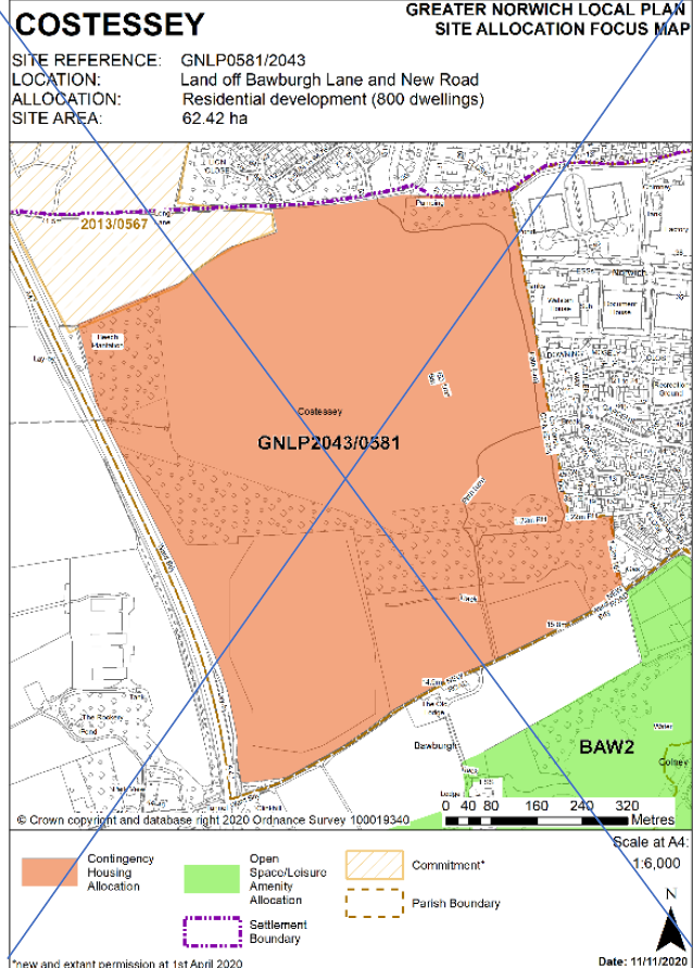
Reasons
Site deleted from plan
MAP72 - GNLP5004R Focus Map
Page -
Modification
Add Focus Map for GNLP5004R Gypsy and Traveller site allocation at Land off Buxton Road, Eastgate, Cawston
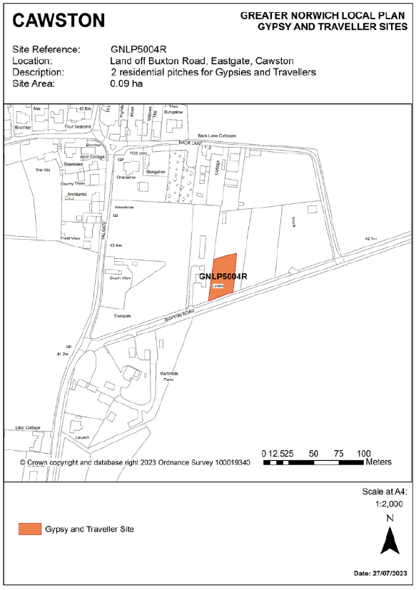
Reasons
Gypsy and Traveller site added to plan
MAP73 - GNLP5022 Focus Map
Page -
Modification
Add Focus Map for GNLP5022 Gypsy and Traveller site allocation at The Oaks, Land off Reepham Road, Foulsham
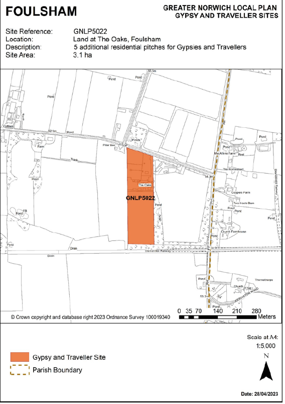
Reasons
Gypsy and Traveller site added to plan
MAP74 - GNLP5027 Focus Map
Page -
Modification
Add Focus Map for GNLP5027 Gypsy and Traveller site allocation at Land off Brick Kiln Road, Hevingham
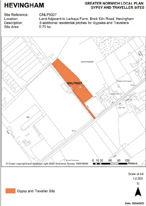
Reasons
Gypsy and Traveller site added to plan
MAP75 - GNLP5019 Focus Map
Page -
Modification
Add Focus Map for GNLP5019 Gypsy and Traveller site allocation at Woodland Stable, Shortthorn Road, Stratton Strawless
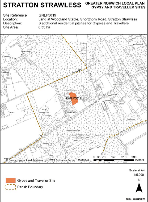
Reasons
Gypsy and Traveller site added to plan
MAP76 - GNLP5020 Focus Map
Page -
Modification
Add Focus Map for GNLP5020 Gypsy and Traveller site allocation at Romany Meadow, The Turnpike, Carleton Rode
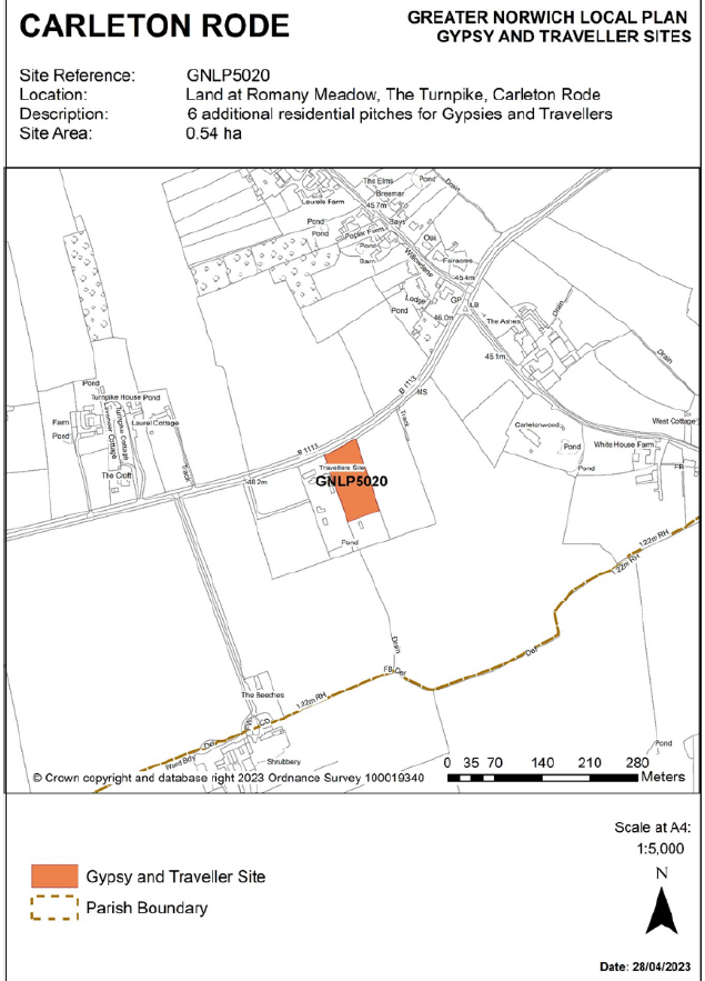
Reasons
Gypsy and Traveller site added to plan
MAP77 - GNLP5024 Focus Map
Page -
Modification
Add Focus Map for GNLP5024 Gypsy and Traveller site allocation at Upgate Street, Carleton Rode
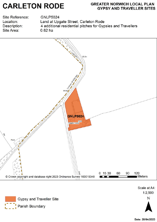
Reasons
Gypsy and Traveller site added to plan
MAP78 - GNLP5013 Focus Map
Page -
Modification
Add Focus Map for GNLP5013 Gypsy and Traveller site allocation at Ketteringham Depot, land east of Station Lane, Ketteringham
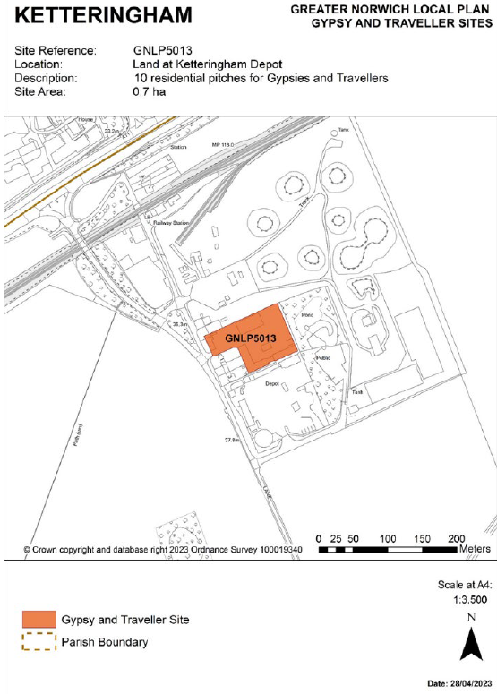
Reasons
Gypsy and Traveller site added to plan
MAP79 - GNLP5028 A and B Focus Map
Page -
Modification
Add Focus Map for GNLP5028 A and B Gypsy and Traveller site allocation at land at Strayground Lane, Wymondham
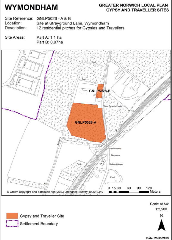
Reasons
Gypsy and Traveller site added to plan
Map80 - Policies Map booklets
Page -
Modification
Update the section of the Introduction relating to ‘Plans to be carried forward and used in conjunction with the Greater Norwich Local Plan:’
After the reference to the South Norfolk Development Management Policies Document (2015) add the following wording:
(Map 1.3(1) Key Diagram March 2013 on page 149 of this document will be superseded by the Key Diagram in the Greater Norwich Local Plan Strategy. The remainder of the document is to be carried forward)
(applies to all Policies Map booklets)
Reasons
To reflect that the Key Diagram from the South Norfolk Development Management Policies Document will be superseded.
Map81 - Policies Map booklets
Page -
Modification
Update the section of the Introduction relating to ‘Neighbourhood plans to be used in conjunction with the Greater Norwich Local Plan:’
Neighbourhood plans to be used in conjunction with the Greater Norwich Local Plan:
| Parish | Authority | Date Made | End Date |
|---|---|---|---|
| Acle | BDC | February 2015 | 2026 |
| Aylsham | BDC | July 2019 | 2038 |
| Blofield | BDC | July 2016 | 2036 |
| Brundall | BDC | May 2016 | 2026 |
| Cringleford | SNC | January 2014 | 2026 |
| Drayton | BDC | July 2016 | 2026 |
| Easton | SNC | December 2017 | 2042 |
| Gt & Lt Plumstead | BDC | July 2015 | 2034 |
| Hellesdon | BDC | December 2017 | 2026 |
| Horsford | BDC | July 2018 | 2038 |
| Long Stratton | SNC | October 2021 | 2036 |
| Mulbarton | SNC | February 2016 | 2030 |
| Old Catton | BDC | July 2016 | 2035 |
| Poringland | SNC | July 2021 | 2039 |
| Rackheath | BDC | July 2017 | 2037 |
| Redenhall with Harleston | SNC | October 2022 | 2038 |
| Salhouse | BDC | July 2017 | 2026 |
| Spixworth | BDC | July 2021 | 2039 |
| Sprowston | BDC | May 2014 | 2026 |
| Starston | SNC | December 2022 | 2042 |
| Strumpshaw | BDC | July 2014 | 2026 |
| Taverham | BDC | July 2021 | 2040 |
| The Tivetshalls | SNC | December 2022 | 2042 |
| Wroxham | BDC | March 2019 | 2039 |
| Wymondham | SNC | July 2023 | 2038 |
In addition, there are 76 qualifying bodies in Broadland which have designated their neighbourhood area and 117 in South Norfolk. This means they have committed to developing a neighbourhood plan. There is also one neighbourhood area designated within Norwich. Of the places preparing neighbourhood plans, two in Broadland have been approved by the local authority to proceed to a referendum. These are in Spixworth and Taverham scheduled for May 2021. However, these plans do currently have significant weight in the planning process. At least two further Neighbourhood Plans are well-advanced, those in Long Stratton and Poringland. Subject to their being approved following an examination and referendum, it is anticipated these could be made by mid-2021.
(applies to all Policies Map booklets)
Reasons
Neighbourhood plan update
Map82 - Policies Map booklets
Page -
Modification
Update the Overview Maps in the Broadland and South Norfolk Policies Map booklets to reflect the change and deletion of sites as appropriate.
(updates to the Norwich overview maps already covered by MAP3 above)
Reasons
Update upon adoption of plan to reflect changes in sites.