4.24
Harleston is identified as a Main Town under policy 7.2. The town has a good range of speciality shops, a local supermarket and a full range of local services (including GPs, secondary school, leisure centre and library). In mid-2019 the estimated population of Harleston was 5,226 people.
4.25
Several brownfield sites have been redeveloped over the past two decades and the largest allocation in the 2015 South Norfolk Local Plan has already been completed, meaning the town has experienced a steady level of growth, as part of its function as a rural hub.
Homes in Harleston
|
Homes at 2020 |
Completed units April 2018 to March 2020 |
Local Plan Allocations remaining at 1 April 2020 |
Other Planning Permissions at 1 April 2020 |
New Allocations |
|---|---|---|---|---|
|
2,515 |
44 |
95 |
33 |
555 |
4.26
Whilst Harleston has good access to the A143, which links Gt Yarmouth to Bury St Edmunds, via Diss, the most direct route to Norwich is on rural ‘B’ roads to the north; therefore it is important to continue to support, and where possible enhance, the services and facilities serving the town and its rural catchment. A variety of local bus services use these routes. The rural catchment of the town not only includes the surrounding villages in South Norfolk, but also extends into Suffolk, and cross-border use of facilities works in both directions, with Harleston Magpies (one of the premier sports clubs in the area), based at Weybread.
4.27
The town is compact in form and sits on a plateau between Starston Beck to the north and the River Waveney to the south, meaning the town is surrounded by River Valley landscape.
4.28
The town centre, which has a designated Conservation Area, has many historic buildings and is based on a triangle of roads comprising The Thoroughfare, Broad Street, The Old Market Place and Exchange Street. This makes the potential for expansion of the town centre is physically limited, therefore limited new retail may be appropriate as part of further housing development. Constraints on town centre parking mean that it will continue to be important to have new housing located within walking distance of the town centre (and other facilities). The compact nature of the town and a choice of sites that facilitates walking to the town centre and other facilities, make it a good location older people’s accommodation.
4.29
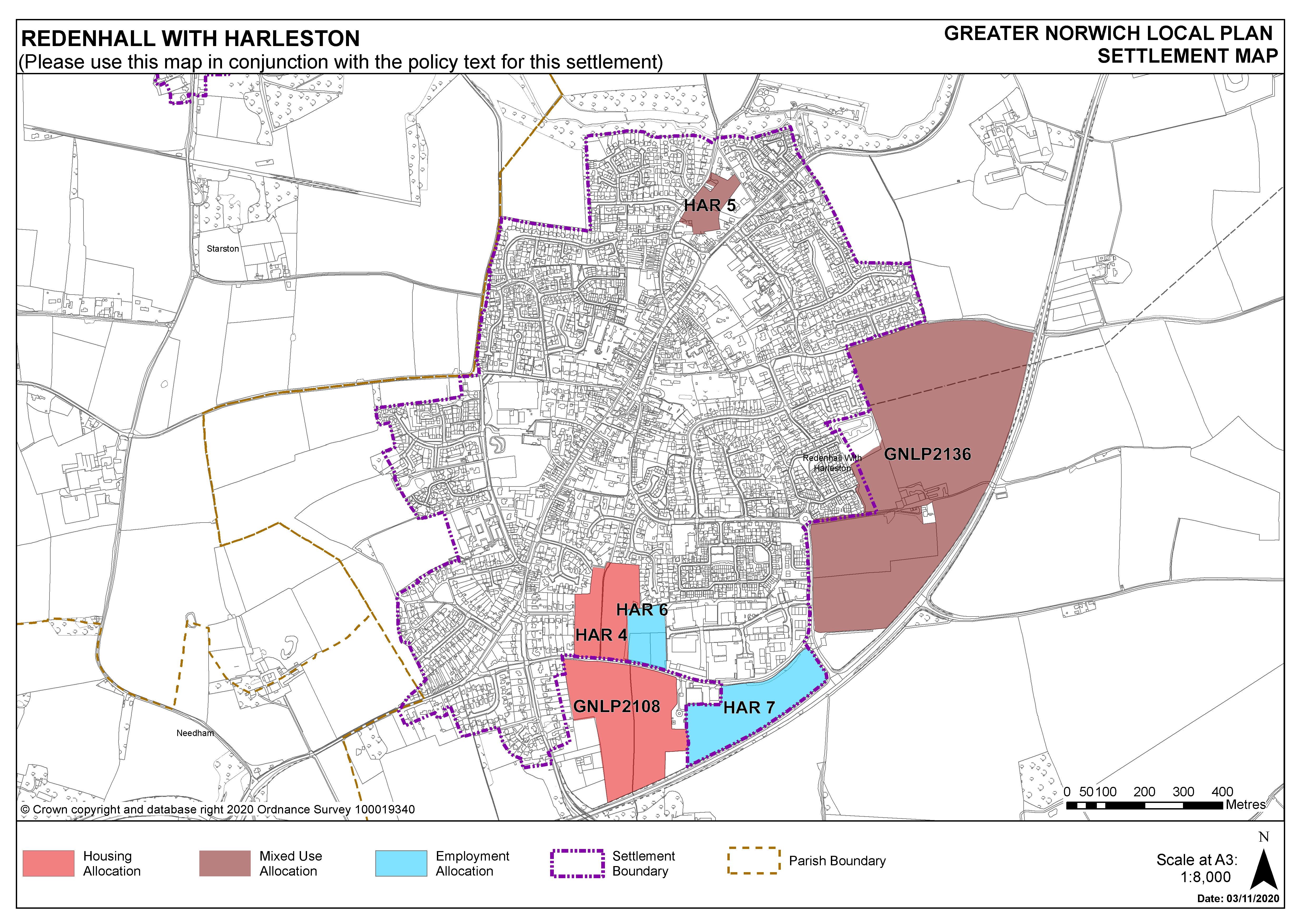
To the south of the town is the main employment area which benefits from good access to the A143. Following the loss of some brownfield employment sites to residential development, there has been some subsequent take up of the existing employment allocations, including the majority of HAR6. However, there remains a need to have land available for employment development to retain the balance of uses within the town and to serve the local catchment (see carried forward allocations, for the remainder of HAR6 and HAR7).
4.30
Existing sewerage infrastructure and surface water flooding are constraints in Harleston, including in the town centre. As a result, all allocated sites will need to show how they will address surface water drainage and sewerage infrastructure constraints to the satisfaction of Anglian Water, the Lead Local Flood Authority and the Environment Agency. A new water supply will be required to provide for the proposed level of growth in Harleston.
4.31
There are two sites allocated in Harleston providing for 555 new homes. The remaining commitment of 172 homes includes one carried forward residential allocation of 95 homes, 44 units completed between April 2018 & March 2020, and 33 units with extant consent at 1 April 2020. This gives a total deliverable housing commitment for Harleston of 727 homes between 2018-2038. A Neighbourhood Area for the preparation of a Neighbourhood Plan covering the Redenhall and Harleston Town Council area was confirmed in September 2020.
4.32
All new and carried forward allocations are expected to address standard requirements associated with development. These vary from place to place but are likely to include mitigations for flood risk (as well as SUDs), highways improvements, safeguarding of minerals resources, land remediation, measures to protect the environment, biodiversity, and landscape intrusion.
Settlement Map