2.122
The site was allocated in the previous Local Plan and was subject to two previous approved schemes on adjoining parts of the site which together would have delivered a total of 20 homes. These permissions have expired, and the site has not yet been developed. The principle of development on the site has already been accepted, and it is expected that development will take place within the new local plan time-period up to 2038. The site is re-allocated for residential use.
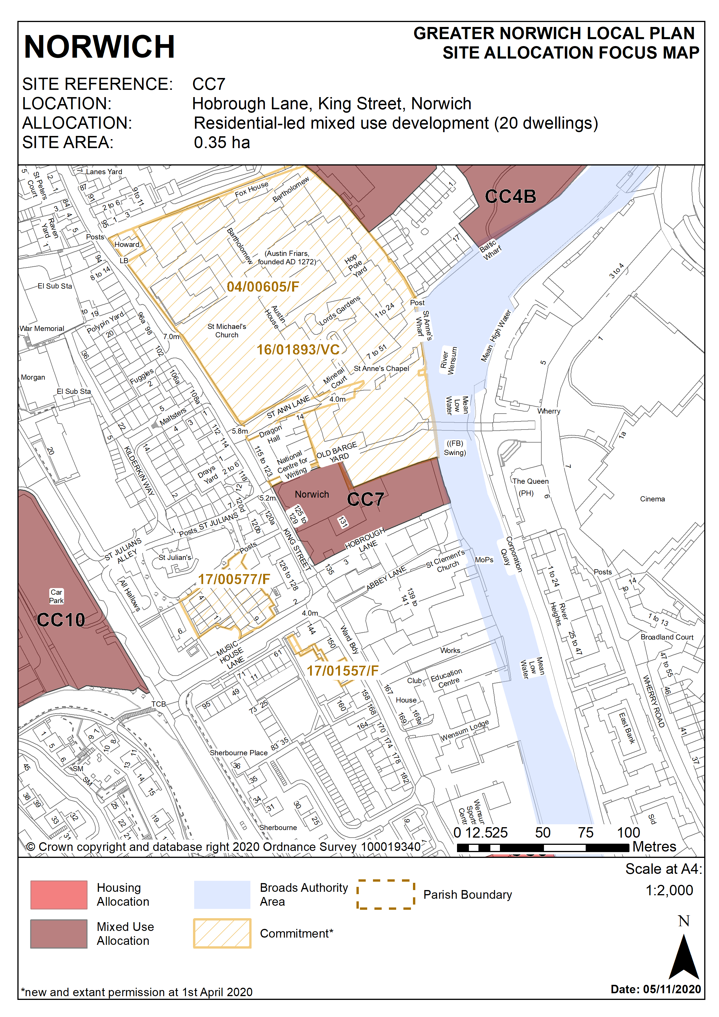
2.123
The site fronts King Street adjacent to Hobrough Lane and extends down to the river Wensum. It is 0.35 hectares in size. It is adjacent to the listed local landmark of Dragon Hall and is close to a strategic pedestrian and cycle link and Lady Julian Bridge, linking the leisure and retail area of Riverside with the primary retail area at Castle Mall.
2.124
The frontage of the site consists of two disused grade II* listed buildings ‘at risk’ (125-127 King Street). These are early 16th century first floor buildings, with a poor quality 20th century arcaded ground floor conversion and rear industrial extensions, surface parking and delivery areas, and are currently unoccupied. These buildings must be brought back into residential use and renovated in order to ensure their future and to remove them from the register.
2.125
The wider King Street area has many historically significant buildings interspersed with former industrial buildings. The area is undergoing significant change as many of the buildings formerly associated with industry and the river are either being replaced or converted, mostly into residential use. The northern part of King Street retains a greater number of traditional buildings and forms a more coherent townscape.
2.126
Redevelopment of the site offers the opportunity to make better use of this valuable city centre site and to continue the development of a vibrant mixed use quarter in King Street, extending housing, leisure office and small scale retailing uses along King Street.
2.127
Development proposals should take account of the City centre conservation area appraisal. The layout and design of the development should ensure the reuse and enhancement of the listed buildings fronting King Street to reveal their significance, and seek to enhance the setting of the adjacent Dragon Hall. The development should also take account of the adjacent St Anne’s Wharf redevelopment and provide a publicly accessible riverside walk linking to the core pedestrian and cycle network at Lady Julian Bridge.
2.128
Development should help to regenerate the King Street area by reinstating the historic street frontage of King Street (ground floor of 125-127 King Street and missing frontage at 131-133 King Street).
2.129
In this highly accessible city centre location, car free housing is appropriate in accordance with policy 2. If this approach is not taken, vehicular access should be via the south of the site/Hobrough Lane.
2.130
Appropriate historic interpretation information should be incorporated into the development and an archaeological assessment will be required.
2.131
Although there are no Tree Preservation Orders on the site, an assessment will have to be undertaken of the value of trees on the river frontage, and appropriate mitigation measures included in any planning application.
2.132
Development should also take into account possible site contamination.
2.133
As part of the site is within flood zone 2, it could be affected by fluvial flooding. In addition, as it is located between the Ber Street ridge and the river Wensum it could be affected by surface water flooding. Therefore a flood risk assessment and appropriate mitigation measures will be required.
2.134
The site lies adjacent to the River Wensum. It is recommended that developers engage in early discussions with the Environment Agency and the Broads Authority.
2.135
Development needs to ensure that the water environment is protected. The site falls within Source Protection Zone 1, designated to protect water supplies, and therefore the water environment is particularly vulnerable in this location. Detailed discussions over this issue will be required with the Environment Agency to ensure that proposals are appropriate for the site and that the site is developed in a manner which protects the water environment. Development of the site must be of a scale and form which respects and takes advantage of its riverside context and location in respect to the Broads National Park.
2.136
As an existing allocation, 20 homes have been considered in the calculation of the housing requirement.
2.137
The site is likely to accommodate at least 20 homes. More homes may be accommodated, subject to an acceptable design and layout etc. being achieved and heritage impact and other constraints being adequately addressed.
Policy CC7
Hobrough Lane, King Street, Norwich (approx. 0.35ha) is allocated for residential-led mixed use development. This will accommodate a minimum of 20 homes.
The development will achieve the following site-specific requirements:
- Residential development with small scale retail and/or offices, food and drink, and tourist uses.
- Development will secure sensitive conversion of historic buildings fronting King Street including removal of the unsympathetic post-war alterations.
- New development should respect the historic integrity and setting of 125-129 King Street and conserve and enhance heritage assets and their settings in this part of the City Centre Conservation Area
- Development will enhance the public realm along King Street and Hobrough Lane and provide a riverside walk linking to the cycle/pedestrian route to Lady Julian Bridge.
- Development will be of a scale and form which respects and takes advantage of its riverside location, providing high quality landscaping, planting and biodiversity enhancements particularly along the river edge
- Heritage interpretation to be provided as part of the scheme.
- 125-127 and 129 King Street is on Norwich’ register of local heritage buildings at risk. Any development of this site must include renovation in order to ensure their future and remove them from the register in agreement with Norwich City Council
- Provide protection of bankside access for maintenance purposes.
Policy Map